Saint-Jean-Poutge
| Saint-Jean-Poutge | |
|---|---|
| Commune | |
 Saint-Jean-Poutge Location within Occitanie region  Saint-Jean-Poutge | |
| Coordinates: 43°43′37″N 0°22′42″E / 43.7269°N 0.3783°ECoordinates: 43°43′37″N 0°22′42″E / 43.7269°N 0.3783°E | |
| Country | France |
| Region | Occitanie |
| Department | Gers |
| Arrondissement | Auch |
| Canton | Fezensac |
| Intercommunality | Cœur de Gascogne |
| Government | |
| • Mayor (2014–2020) | Phillipe Lafforgue |
| Area1 | 10.8 km2 (4.2 sq mi) |
| Population (2012)2 | 319 |
| • Density | 30/km2 (77/sq mi) |
| Time zone | UTC+1 (CET) |
| • Summer (DST) | UTC+2 (CEST) |
| INSEE/Postal code | 32382 /32190 |
| Elevation |
105–225 m (344–738 ft) (avg. 152 m or 499 ft) |
|
1 French Land Register data, which excludes lakes, ponds, glaciers > 1 km2 (0.386 sq mi or 247 acres) and river estuaries. 2 Population without double counting: residents of multiple communes (e.g., students and military personnel) only counted once. | |
Saint-Jean-Poutge is a commune in the Gers department in southwestern France.
Geography
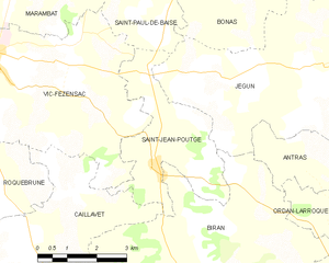
Saint-Jean-Poutge and its surrounding communes
Population
| Historical population | ||
|---|---|---|
| Year | Pop. | ±% |
| 1962 | 329 | — |
| 1968 | 326 | −0.9% |
| 1975 | 322 | −1.2% |
| 1982 | 314 | −2.5% |
| 1990 | 283 | −9.9% |
| 1999 | 239 | −15.5% |
| 2008 | 291 | +21.8% |
| 2012 | 319 | +9.6% |
Monuments
- Château de Herrebouc, an older castle remodelled by a major campaign of construction work at the start of the 17th century.[1]
See also
References
- ↑ Ministry of Culture: Château de Herrebouc (in French)
| Wikimedia Commons has media related to Saint-Jean-Poutge. |
| Authority control |
|---|
This article is issued from
Wikipedia.
The text is licensed under Creative Commons - Attribution - Sharealike.
Additional terms may apply for the media files.