Monblanc
| Monblanc | |
|---|---|
| Commune | |
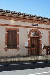 The town hall | |
 Monblanc Location within Occitanie region  Monblanc | |
| Coordinates: 43°27′54″N 0°59′28″E / 43.465°N 0.9911°ECoordinates: 43°27′54″N 0°59′28″E / 43.465°N 0.9911°E | |
| Country | France |
| Region | Occitanie |
| Department | Gers |
| Arrondissement | Auch |
| Canton | Val de Save |
| Intercommunality | Savès |
| Government | |
| • Mayor (2008–2014) | Bernard Ribes |
| Area1 | 12.93 km2 (4.99 sq mi) |
| Population (2008)2 | 360 |
| • Density | 28/km2 (72/sq mi) |
| Time zone | UTC+1 (CET) |
| • Summer (DST) | UTC+2 (CEST) |
| INSEE/Postal code | 32261 /32130 |
| Elevation |
162–306 m (531–1,004 ft) (avg. 235 m or 771 ft) |
|
1 French Land Register data, which excludes lakes, ponds, glaciers > 1 km2 (0.386 sq mi or 247 acres) and river estuaries. 2 Population without double counting: residents of multiple communes (e.g., students and military personnel) only counted once. | |
Monblanc is a commune in the Gers department in southwestern France.
Geography
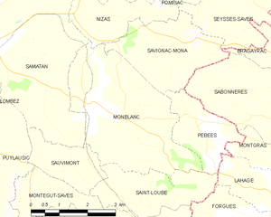
Monblanc and its surrounding communes
Population
| Historical population | ||
|---|---|---|
| Year | Pop. | ±% |
| 1962 | 300 | — |
| 1968 | 288 | −4.0% |
| 1975 | 270 | −6.2% |
| 1982 | 276 | +2.2% |
| 1990 | 251 | −9.1% |
| 1999 | 286 | +13.9% |
| 2008 | 360 | +25.9% |
See also
References
| Wikimedia Commons has media related to Monblanc. |
| Authority control |
|---|
This article is issued from
Wikipedia.
The text is licensed under Creative Commons - Attribution - Sharealike.
Additional terms may apply for the media files.