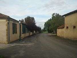
Monferran-Plavès
| Monferran-Plavès | |
|---|---|
| Commune | |
 | |
 Monferran-Plavès Location within Occitanie region  Monferran-Plavès | |
| Coordinates: 43°29′35″N 0°38′24″E / 43.4931°N 0.64°ECoordinates: 43°29′35″N 0°38′24″E / 43.4931°N 0.64°E | |
| Country | France |
| Region | Occitanie |
| Department | Gers |
| Arrondissement | Mirande |
| Canton | Astarac-Gimone |
| Intercommunality | Val de Gers |
| Government | |
| • Mayor (2008–2014) | Alban Bataille |
| Area1 | 11.07 km2 (4.27 sq mi) |
| Population (2008)2 | 126 |
| • Density | 11/km2 (29/sq mi) |
| Time zone | UTC+1 (CET) |
| • Summer (DST) | UTC+2 (CEST) |
| INSEE/Postal code | 32267 /32260 |
| Elevation |
190–294 m (623–965 ft) (avg. 300 m or 980 ft) |
|
1 French Land Register data, which excludes lakes, ponds, glaciers > 1 km2 (0.386 sq mi or 247 acres) and river estuaries. 2 Population without double counting: residents of multiple communes (e.g., students and military personnel) only counted once. | |
Monferran-Plavès is a commune in the Gers department in southwestern France.
Geography
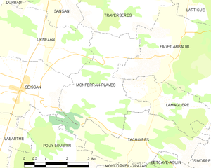
Monferran-Plavès and its surrounding communes
Population
| Historical population | ||
|---|---|---|
| Year | Pop. | ±% |
| 1962 | 104 | — |
| 1968 | 131 | +26.0% |
| 1975 | 110 | −16.0% |
| 1982 | 111 | +0.9% |
| 1990 | 119 | +7.2% |
| 1999 | 111 | −6.7% |
| 2008 | 126 | +13.5% |
See also
References
| Wikimedia Commons has media related to Monferran-Plavès. |
| Authority control |
|---|
This article is issued from
Wikipedia.
The text is licensed under Creative Commons - Attribution - Sharealike.
Additional terms may apply for the media files.