Lagarde-Hachan
| Lagarde-Hachan | |
|---|---|
| Commune | |
 | |
 Lagarde-Hachan Location within Occitanie region  Lagarde-Hachan | |
| Coordinates: 43°24′27″N 0°29′40″E / 43.4075°N 0.4944°ECoordinates: 43°24′27″N 0°29′40″E / 43.4075°N 0.4944°E | |
| Country | France |
| Region | Occitanie |
| Department | Gers |
| Arrondissement | Mirande |
| Canton | Mirande-Astarac |
| Intercommunality | Vals et villages en Astarac |
| Government | |
| • Mayor (2008–2014) | Francis Lescure |
| Area1 | 8.57 km2 (3.31 sq mi) |
| Population (2008)2 | 165 |
| • Density | 19/km2 (50/sq mi) |
| Time zone | UTC+1 (CET) |
| • Summer (DST) | UTC+2 (CEST) |
| INSEE/Postal code | 32177 /32300 |
| Elevation |
202–285 m (663–935 ft) (avg. 300 m or 980 ft) |
|
1 French Land Register data, which excludes lakes, ponds, glaciers > 1 km2 (0.386 sq mi or 247 acres) and river estuaries. 2 Population without double counting: residents of multiple communes (e.g., students and military personnel) only counted once. | |
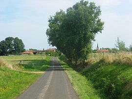
Lagarde-Hachan is a commune in the Gers department in southwestern France.
Geography
The Petite Baïse forms part of the commune's western border.
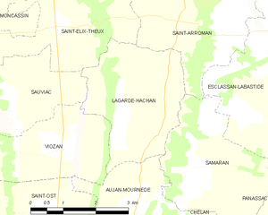
Lagarde-Hachan and its surrounding communes
Population
| Historical population | ||
|---|---|---|
| Year | Pop. | ±% |
| 1962 | 194 | — |
| 1968 | 187 | −3.6% |
| 1975 | 154 | −17.6% |
| 1982 | 131 | −14.9% |
| 1990 | 118 | −9.9% |
| 1999 | 131 | +11.0% |
| 2008 | 165 | +26.0% |
See also
References
| Wikimedia Commons has media related to Lagarde-Hachan. |
This article is issued from
Wikipedia.
The text is licensed under Creative Commons - Attribution - Sharealike.
Additional terms may apply for the media files.