Saint-Léonard, Gers
| Saint-Léonard | |
|---|---|
| Commune | |
 Saint-Léonard Location within Occitanie region  Saint-Léonard | |
| Coordinates: 43°51′35″N 0°46′11″E / 43.8597°N 0.7697°ECoordinates: 43°51′35″N 0°46′11″E / 43.8597°N 0.7697°E | |
| Country | France |
| Region | Occitanie |
| Department | Gers |
| Arrondissement | Condom |
| Canton | Fleurance-Lomagne |
| Intercommunality | Cœur de Lomagne |
| Government | |
| • Mayor (2008–2014) | Gervais Molas |
| Area1 | 13.11 km2 (5.06 sq mi) |
| Population (2008)2 | 170 |
| • Density | 13/km2 (34/sq mi) |
| Time zone | UTC+1 (CET) |
| • Summer (DST) | UTC+2 (CEST) |
| INSEE/Postal code | 32385 /32380 |
| Elevation |
96–192 m (315–630 ft) (avg. 192 m or 630 ft) |
|
1 French Land Register data, which excludes lakes, ponds, glaciers > 1 km2 (0.386 sq mi or 247 acres) and river estuaries. 2 Population without double counting: residents of multiple communes (e.g., students and military personnel) only counted once. | |
Saint-Léonard is a commune in the Gers department in southwestern France.
Geography
The river Auroue forms all of the commune's western border.
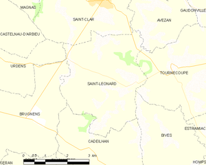
Saint-Léonard and its surrounding communes
Population
| Historical population | ||
|---|---|---|
| Year | Pop. | ±% |
| 1962 | 224 | — |
| 1968 | 208 | −7.1% |
| 1975 | 190 | −8.7% |
| 1982 | 179 | −5.8% |
| 1990 | 161 | −10.1% |
| 1999 | 143 | −11.2% |
| 2008 | 170 | +18.9% |
See also
References
| Wikimedia Commons has media related to Saint-Léonard (Gers). |
This article is issued from
Wikipedia.
The text is licensed under Creative Commons - Attribution - Sharealike.
Additional terms may apply for the media files.