Castet-Arrouy
| Castet-Arrouy | ||
|---|---|---|
| Commune | ||
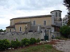 Church of Saint Blandine | ||
| ||
 Castet-Arrouy Location within Occitanie region  Castet-Arrouy | ||
| Coordinates: 43°58′50″N 0°43′00″E / 43.9806°N 0.7167°ECoordinates: 43°58′50″N 0°43′00″E / 43.9806°N 0.7167°E | ||
| Country | France | |
| Region | Occitanie | |
| Department | Gers | |
| Arrondissement | Condom | |
| Canton | Lectoure-Lomagne | |
| Intercommunality | Lomagne Gersoise | |
| Government | ||
| • Mayor (2001–2008) | Albert Sala | |
| Area1 | 8.04 km2 (3.10 sq mi) | |
| Population (2008)2 | 182 | |
| • Density | 23/km2 (59/sq mi) | |
| Time zone | UTC+1 (CET) | |
| • Summer (DST) | UTC+2 (CEST) | |
| INSEE/Postal code | 32085 /32340 | |
| Elevation |
87–180 m (285–591 ft) (avg. 107 m or 351 ft) | |
|
1 French Land Register data, which excludes lakes, ponds, glaciers > 1 km2 (0.386 sq mi or 247 acres) and river estuaries. 2 Population without double counting: residents of multiple communes (e.g., students and military personnel) only counted once. | ||
.svg.png)
Castet-Arrouy is a commune in the Gers department in southwestern France.
Geography
The river Auroue flows north through the commune and forms part of its northeastern border.
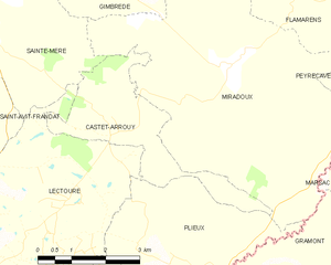
Castet-Arrouy and its surrounding communes
Population
| Historical population | ||
|---|---|---|
| Year | Pop. | ±% |
| 1962 | 163 | — |
| 1968 | 174 | +6.7% |
| 1975 | 145 | −16.7% |
| 1982 | 133 | −8.3% |
| 1990 | 132 | −0.8% |
| 1999 | 144 | +9.1% |
| 2008 | 182 | +26.4% |
Sites of interest
The Church of Saint Blandine is the main church of Castet-Arrouy. The choir was painted with murals by artist Paul Noël Lasseran in 1901.
See also
References
| Wikimedia Commons has media related to Castet-Arrouy. |
This article is issued from
Wikipedia.
The text is licensed under Creative Commons - Attribution - Sharealike.
Additional terms may apply for the media files.