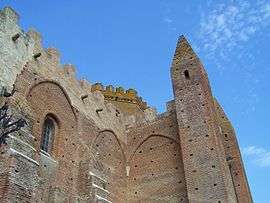
Simorre
| Simorre | ||
|---|---|---|
| Commune | ||
 | ||
| ||
 Simorre Location within Occitanie region  Simorre | ||
| Coordinates: 43°27′04″N 0°44′09″E / 43.4511°N 0.7358°ECoordinates: 43°27′04″N 0°44′09″E / 43.4511°N 0.7358°E | ||
| Country | France | |
| Region | Occitanie | |
| Department | Gers | |
| Arrondissement | Auch | |
| Canton | Val de Save | |
| Intercommunality | Coteaux de Gimone | |
| Government | ||
| • Mayor (2008–2014) | Claude Silberzahn | |
| Area1 | 35.85 km2 (13.84 sq mi) | |
| Population (2008)2 | 654 | |
| • Density | 18/km2 (47/sq mi) | |
| Time zone | UTC+1 (CET) | |
| • Summer (DST) | UTC+2 (CEST) | |
| INSEE/Postal code | 32433 /32420 | |
| Elevation |
182–321 m (597–1,053 ft) (avg. 180 m or 590 ft) | |
|
1 French Land Register data, which excludes lakes, ponds, glaciers > 1 km2 (0.386 sq mi or 247 acres) and river estuaries. 2 Population without double counting: residents of multiple communes (e.g., students and military personnel) only counted once. | ||
.svg.png)
Simorre is a commune in the Gers department in southwestern France.
Geography
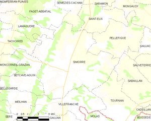
Simorre and its surrounding communes
Population
| Historical population | ||
|---|---|---|
| Year | Pop. | ±% |
| 1962 | 891 | — |
| 1968 | 911 | +2.2% |
| 1975 | 806 | −11.5% |
| 1982 | 804 | −0.2% |
| 1990 | 708 | −11.9% |
| 1999 | 698 | −1.4% |
| 2008 | 654 | −6.3% |
See also
References
| Wikimedia Commons has media related to Simorre. |
This article is issued from
Wikipedia.
The text is licensed under Creative Commons - Attribution - Sharealike.
Additional terms may apply for the media files.