Saint-Orens-Pouy-Petit
| Saint-Orens-Pouy-Petit | |
|---|---|
| Commune | |
 | |
 Saint-Orens-Pouy-Petit Location within Occitanie region  Saint-Orens-Pouy-Petit | |
| Coordinates: 43°55′04″N 0°26′05″E / 43.9178°N 0.4347°ECoordinates: 43°55′04″N 0°26′05″E / 43.9178°N 0.4347°E | |
| Country | France |
| Region | Occitanie |
| Department | Gers |
| Arrondissement | Condom |
| Canton | Baïse-Armagnac |
| Government | |
| • Mayor (2014–2020) | Michel Meste |
| Area1 | 11.31 km2 (4.37 sq mi) |
| Population (2008)2 | 142 |
| • Density | 13/km2 (33/sq mi) |
| Time zone | UTC+1 (CET) |
| • Summer (DST) | UTC+2 (CEST) |
| INSEE/Postal code | 32400 /32100 |
| Elevation |
97–225 m (318–738 ft) (avg. 200 m or 660 ft) |
|
1 French Land Register data, which excludes lakes, ponds, glaciers > 1 km2 (0.386 sq mi or 247 acres) and river estuaries. 2 Population without double counting: residents of multiple communes (e.g., students and military personnel) only counted once. | |
Saint-Orens-Pouy-Petit is a commune in the Gers department in southwestern France.
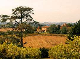
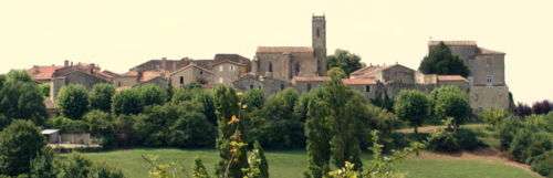
Central to the commune is the classic Gers Pierre Blanche bastide of St Orens, consisting of a walled community on a fierce outcrop of rock, situated 2 km to the east of the D654 between Condom and Saint-Puy. St Orens has views to the south, including the Pyrenees in fine weather.
On a facing hill is the hamlet of Hameau de Pouy-Petit.
Saint Orens holds a Catholic church and the Château St Orens (sixteenth century). Hameau de Pouy-Petit has the Château gascon de Pouy-Petit (eighteenth century).
Geography
Population
| Historical population | ||
|---|---|---|
| Year | Pop. | ±% |
| 1962 | 191 | — |
| 1968 | 209 | +9.4% |
| 1975 | 172 | −17.7% |
| 1982 | 207 | +20.3% |
| 1990 | 190 | −8.2% |
| 1999 | 141 | −25.8% |
| 2008 | 142 | +0.7% |
Economy
- Agriculture
St Orens sits within of a large agricultural region, with common crops including corn, colza, sunflowers and grain. There are also a number of vineyards, producing grapes for wine or distilling.
Local market towns are known for their fine fruit and vegetables, particularly Condom, Nérac and Lectoure
Other products from local producers include:
Sites of interest
- Fortified village walls (St Orens) - St Orens is enclosed by white stone walls (incomplete in sections) dating to the thirteenth century
- Château de St Orens (sixteenth century) - forming the western end of the fortified village, now containing the Salle de Fête (a function and exhibition space) and Mairie (mayor's office). The chateau was given to a lieutenant of the French gentleman soldier Blaise de Monluc, based in Saint-Puy.
- Château de Pouy-Petit (eighteenth century)
- Lavoir: a reconstructed washing area below St Orens, used by the villagers prior to modern plumbing
- Library
- Ceramics workshop and gallery
- Brocante
- Rare and vintage button shop
- Tennis court
- Boule patch
Arts
Like much of the Gers, St Orens had seen a slow period of decline through the twentieth century, leaving a number of properties in the village empty. An influx of newcomers and returnees in the 1970s and 1980s helped reverse this process. A number of these people were artists and artisans, creating a vibrant artistic community. The Salle de Fête regularly hosts arts exhibitions by local artists, and the nearby Musée d'Art Naïf (Béraut) compliments this picture.
Flora and fauna
Observed around the bastide:
- Mammals
Coypu, various deer species, wild boar
- Birds
Barn owl, golden oriole, hoopoe, black redstart, kestrel, common buzzard, black kite, greenfinch, rock bunting, pigeon
- Butterflies
Orange tip, peacock, southern swallowtail, clouded yellow, small blue, white admiral, red admiral, painted lady, Queen of Spain fritillary
See also
References
| Wikimedia Commons has media related to Saint-Orens-Pouy-Petit. |
| Authority control |
|---|