Aignan, Gers
| Aignan | ||
|---|---|---|
| Commune | ||
.JPG) | ||
| ||
 Aignan Location within Occitanie region  Aignan | ||
| Coordinates: 43°41′55″N 0°05′03″E / 43.6986°N 0.0842°ECoordinates: 43°41′55″N 0°05′03″E / 43.6986°N 0.0842°E | ||
| Country | France | |
| Region | Occitanie | |
| Department | Gers | |
| Arrondissement | Mirande | |
| Canton | Adour-Gersoise | |
| Intercommunality | Armagnac-Adour | |
| Government | ||
| • Mayor (2014-2020) | Philippe Baratault | |
| Area1 | 32.16 km2 (12.42 sq mi) | |
| Population (2014)2 | 738 | |
| • Density | 23/km2 (59/sq mi) | |
| Time zone | UTC+1 (CET) | |
| • Summer (DST) | UTC+2 (CEST) | |
| INSEE/Postal code | 32001 /32290 | |
| Elevation |
107–222 m (351–728 ft) (avg. 165 m or 541 ft) | |
|
1 French Land Register data, which excludes lakes, ponds, glaciers > 1 km2 (0.386 sq mi or 247 acres) and river estuaries. 2 Population without double counting: residents of multiple communes (e.g., students and military personnel) only counted once. | ||
.svg.png)
Aignan (French pronunciation: [ɛɲɑ̃]; Gascon: Anhan [aˈɲa]) is a commune in the Gers department in southwestern France.
Geography
Aignan is located in the canton of Adour-Gersoise and in the arrondissement of Mirande.
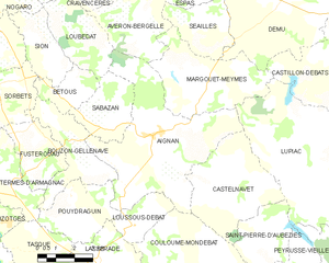
Map of Aignan and its surrounding communes
Population
| Historical population | ||
|---|---|---|
| Year | Pop. | ±% |
| 1793 | 1,413 | — |
| 1800 | 1,427 | +1.0% |
| 1806 | 1,469 | +2.9% |
| 1821 | 1,492 | +1.6% |
| 1831 | 1,771 | +18.7% |
| 1841 | 1,630 | −8.0% |
| 1846 | 1,639 | +0.6% |
| 1851 | 1,618 | −1.3% |
| 1856 | 1,686 | +4.2% |
| 1861 | 1,649 | −2.2% |
| 1866 | 1,700 | +3.1% |
| 1872 | 1,703 | +0.2% |
| 1876 | 1,612 | −5.3% |
| 1881 | 1,649 | +2.3% |
| 1886 | 1,595 | −3.3% |
| 1891 | 1,500 | −6.0% |
| 1896 | 1,517 | +1.1% |
| 1901 | 1,350 | −11.0% |
| 1906 | 1,215 | −10.0% |
| 1911 | 1,247 | +2.6% |
| 1921 | 1,088 | −12.8% |
| 1926 | 1,139 | +4.7% |
| 1931 | 1,175 | +3.2% |
| 1936 | 959 | −18.4% |
| 1946 | 1,035 | +7.9% |
| 1954 | 950 | −8.2% |
| 1962 | 898 | −5.5% |
| 1968 | 965 | +7.5% |
| 1975 | 932 | −3.4% |
| 1982 | 941 | +1.0% |
| 1990 | 921 | −2.1% |
| 1999 | 844 | −8.4% |
| 2008 | 830 | −1.7% |
| 2012 | 746 | −10.1% |
See also
References
| Wikimedia Commons has media related to Aignan. |
This article is issued from
Wikipedia.
The text is licensed under Creative Commons - Attribution - Sharealike.
Additional terms may apply for the media files.