Courrensan
| Courrensan | |
|---|---|
| Commune | |
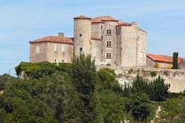 Chateau | |
 Courrensan Location within Occitanie region  Courrensan | |
| Coordinates: 43°51′00″N 0°14′37″E / 43.85°N 0.2436°ECoordinates: 43°51′00″N 0°14′37″E / 43.85°N 0.2436°E | |
| Country | France |
| Region | Occitanie |
| Department | Gers |
| Arrondissement | Condom |
| Canton | Fezensac |
| Government | |
| • Mayor (2008–2014) | Honorine Burgan |
| Area1 | 25.16 km2 (9.71 sq mi) |
| Population (2008)2 | 380 |
| • Density | 15/km2 (39/sq mi) |
| Time zone | UTC+1 (CET) |
| • Summer (DST) | UTC+2 (CEST) |
| INSEE/Postal code | 32110 /32330 |
| Elevation |
95–178 m (312–584 ft) (avg. 245 m or 804 ft) |
|
1 French Land Register data, which excludes lakes, ponds, glaciers > 1 km2 (0.386 sq mi or 247 acres) and river estuaries. 2 Population without double counting: residents of multiple communes (e.g., students and military personnel) only counted once. | |
Courrensan is a commune in the Gers department in southwestern France.
Geography
The Auzoue forms part of the commune's southern border, then flows north-northwest through the middle of the commune.
The village lies in the middle of the commune, on the right bank of the Auzoue.

Courrensan and its surrounding communes
Population
| Historical population | ||
|---|---|---|
| Year | Pop. | ±% |
| 1962 | 389 | — |
| 1968 | 461 | +18.5% |
| 1975 | 457 | −0.9% |
| 1982 | 383 | −16.2% |
| 1990 | 369 | −3.7% |
| 1999 | 375 | +1.6% |
| 2008 | 380 | +1.3% |
See also
References
| Wikimedia Commons has media related to Courrensan. |
This article is issued from
Wikipedia.
The text is licensed under Creative Commons - Attribution - Sharealike.
Additional terms may apply for the media files.