Jegun
| Jegun | ||
|---|---|---|
| Commune | ||
 | ||
| ||
 Jegun Location within Occitanie region  Jegun | ||
| Coordinates: 43°45′29″N 0°27′37″E / 43.7581°N 0.4603°ECoordinates: 43°45′29″N 0°27′37″E / 43.7581°N 0.4603°E | ||
| Country | France | |
| Region | Occitanie | |
| Department | Gers | |
| Arrondissement | Auch | |
| Canton | Gascogne-Auscitaine | |
| Intercommunality | Cœur de Gascogne | |
| Government | ||
| • Mayor (2008–2014) | Alain Descousses | |
| Area1 | 39.25 km2 (15.15 sq mi) | |
| Population (2008)2 | 1,136 | |
| • Density | 29/km2 (75/sq mi) | |
| Time zone | UTC+1 (CET) | |
| • Summer (DST) | UTC+2 (CEST) | |
| INSEE/Postal code | 32162 /32360 | |
| Elevation |
105–242 m (344–794 ft) (avg. 220 m or 720 ft) | |
|
1 French Land Register data, which excludes lakes, ponds, glaciers > 1 km2 (0.386 sq mi or 247 acres) and river estuaries. 2 Population without double counting: residents of multiple communes (e.g., students and military personnel) only counted once. | ||
.svg.png)
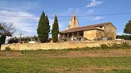
Jegun is a commune in the Gers department in southwestern France.
Geography
The village lies 17 km (11 mi) from Auch.
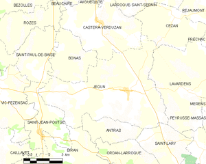
Jegun and its surrounding communes
History
The village was founded in the 11th century and fortified around 1180 by Bernard IV, count of Armagnac. It is a bastide, the original layout is still preserved today. In 1577, Henri de Navarre, also known as Henry IV, hid in one of the streets ("La Grande Rue", the central street of the village) to escape enemy troops commanded by Villars, the Governor of Guyenna.
Population
| Historical population | ||
|---|---|---|
| Year | Pop. | ±% |
| 1962 | 1,086 | — |
| 1968 | 1,084 | −0.2% |
| 1975 | 971 | −10.4% |
| 1982 | 949 | −2.3% |
| 1990 | 976 | +2.8% |
| 1999 | 968 | −0.8% |
| 2008 | 1,136 | +17.4% |
Events
None. But there are plenty of barking dogs...
See also
References
External links
| Wikimedia Commons has media related to Jegun. |
This article is issued from
Wikipedia.
The text is licensed under Creative Commons - Attribution - Sharealike.
Additional terms may apply for the media files.