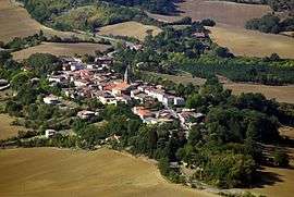
Puycasquier
| Puycasquier | |
|---|---|
| Commune | |
 | |
 Puycasquier Location within Occitanie region  Puycasquier | |
| Coordinates: 43°44′50″N 0°44′54″E / 43.7472°N 0.7483°ECoordinates: 43°44′50″N 0°44′54″E / 43.7472°N 0.7483°E | |
| Country | France |
| Region | Occitanie |
| Department | Gers |
| Arrondissement | Auch |
| Canton | Gascogne-Auscitaine |
| Intercommunality | Cœur de Gascogne |
| Government | |
| • Mayor (2008–2014) | Serge Cardonne |
| Area1 | 20.14 km2 (7.78 sq mi) |
| Population (2008)2 | 433 |
| • Density | 21/km2 (56/sq mi) |
| Time zone | UTC+1 (CET) |
| • Summer (DST) | UTC+2 (CEST) |
| INSEE/Postal code | 32335 /32120 |
| Elevation |
146–264 m (479–866 ft) (avg. 252 m or 827 ft) |
|
1 French Land Register data, which excludes lakes, ponds, glaciers > 1 km2 (0.386 sq mi or 247 acres) and river estuaries. 2 Population without double counting: residents of multiple communes (e.g., students and military personnel) only counted once. | |
Puycasquier (Puicasquèr in Gascon) is a commune in the Gers department in southwestern France.
Geography
Localisation
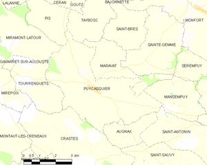
Puycasquier and its surrounding communes
Hydrography
The river Auroue flows north-northwest through the western part of the commune.
Population
| Historical population | ||
|---|---|---|
| Year | Pop. | ±% |
| 1962 | 506 | — |
| 1968 | 507 | +0.2% |
| 1975 | 468 | −7.7% |
| 1982 | 431 | −7.9% |
| 1990 | 436 | +1.2% |
| 1999 | 424 | −2.8% |
| 2008 | 433 | +2.1% |
History
Home to the historic 'Gachet' family.
See also
References
| Wikimedia Commons has media related to Puycasquier. |
| Authority control |
|---|
This article is issued from
Wikipedia.
The text is licensed under Creative Commons - Attribution - Sharealike.
Additional terms may apply for the media files.