Montesquiou
| Montesquiou | ||
|---|---|---|
| Commune | ||
 | ||
| ||
 Montesquiou Location within Occitanie region  Montesquiou | ||
| Coordinates: 43°34′46″N 0°19′47″E / 43.5794°N 0.3297°ECoordinates: 43°34′46″N 0°19′47″E / 43.5794°N 0.3297°E | ||
| Country | France | |
| Region | Occitanie | |
| Department | Gers | |
| Arrondissement | Mirande | |
| Canton | Pardiac-Rivière-Basse | |
| Intercommunality | Cœur d'Astarac en Gascogne | |
| Government | ||
| • Mayor (2008–2014) | Robert Perrussan | |
| Area1 | 46.8 km2 (18.1 sq mi) | |
| Population (2008)2 | 605 | |
| • Density | 13/km2 (33/sq mi) | |
| Time zone | UTC+1 (CET) | |
| • Summer (DST) | UTC+2 (CEST) | |
| INSEE/Postal code | 32285 /32320 | |
| Elevation |
145–256 m (476–840 ft) (avg. 277 m or 909 ft) | |
|
1 French Land Register data, which excludes lakes, ponds, glaciers > 1 km2 (0.386 sq mi or 247 acres) and river estuaries. 2 Population without double counting: residents of multiple communes (e.g., students and military personnel) only counted once. | ||
.svg.png)
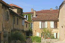
Montesquiou is a commune in the Gers department in southwestern France. It is the historic seat of the Montesquiou family.
Geography
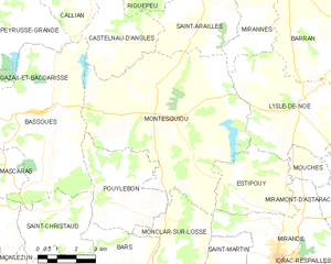
Montesquiou and its surrounding communes
Population
| Historical population | ||
|---|---|---|
| Year | Pop. | ±% |
| 1962 | 538 | — |
| 1968 | 645 | +19.9% |
| 1975 | 605 | −6.2% |
| 1982 | 604 | −0.2% |
| 1990 | 579 | −4.1% |
| 1999 | 570 | −1.6% |
| 2008 | 605 | +6.1% |
See also
References
| Wikimedia Commons has media related to Montesquiou (Gers). |
This article is issued from
Wikipedia.
The text is licensed under Creative Commons - Attribution - Sharealike.
Additional terms may apply for the media files.