Miramont-Latour
| Miramont-Latour | |
|---|---|
| Commune | |
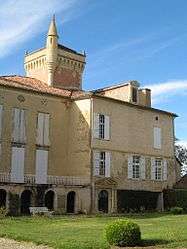 Chateau | |
 Miramont-Latour Location within Occitanie region  Miramont-Latour | |
| Coordinates: 43°46′30″N 0°41′01″E / 43.775°N 0.6836°ECoordinates: 43°46′30″N 0°41′01″E / 43.775°N 0.6836°E | |
| Country | France |
| Region | Occitanie |
| Department | Gers |
| Arrondissement | Condom |
| Canton | Fleurance-Lomagne |
| Intercommunality | Lomagne Gersoise |
| Government | |
| • Mayor (2008–2014) | Patrick de Lary de Latour |
| Area1 | 9.77 km2 (3.77 sq mi) |
| Population (2008)2 | 151 |
| • Density | 15/km2 (40/sq mi) |
| Time zone | UTC+1 (CET) |
| • Summer (DST) | UTC+2 (CEST) |
| INSEE/Postal code | 32255 /32390 |
| Elevation |
105–202 m (344–663 ft) (avg. 265 m or 869 ft) |
|
1 French Land Register data, which excludes lakes, ponds, glaciers > 1 km2 (0.386 sq mi or 247 acres) and river estuaries. 2 Population without double counting: residents of multiple communes (e.g., students and military personnel) only counted once. | |
Miramont-Latour is a commune in the Gers department in southwestern France.
Geography

Miramont-Latour and its surrounding communes
The river Auroue forms part of the commune's eastern border.
Population
| Historical population | ||
|---|---|---|
| Year | Pop. | ±% |
| 1962 | 141 | — |
| 1968 | 167 | +18.4% |
| 1975 | 122 | −26.9% |
| 1982 | 112 | −8.2% |
| 1990 | 125 | +11.6% |
| 1999 | 136 | +8.8% |
| 2008 | 151 | +11.0% |
See also
References
| Wikimedia Commons has media related to Miramont-Latour. |
| Authority control |
|---|
This article is issued from
Wikipedia.
The text is licensed under Creative Commons - Attribution - Sharealike.
Additional terms may apply for the media files.