Auterive, Gers
| Auterive | |
|---|---|
| Commune | |
 | |
 Auterive Location within Occitanie region  Auterive | |
| Coordinates: 43°35′01″N 0°36′54″E / 43.5836°N 0.615°ECoordinates: 43°35′01″N 0°36′54″E / 43.5836°N 0.615°E | |
| Country | France |
| Region | Occitanie |
| Department | Gers |
| Arrondissement | Auch |
| Canton | Auch-3 |
| Intercommunality | CA Grand Auch Cœur Gascogne |
| Government | |
| • Mayor (2015-2020) | Bernard Pensivy |
| Area1 | 10.79 km2 (4.17 sq mi) |
| Population (2015)2 | 527 |
| • Density | 49/km2 (130/sq mi) |
| Time zone | UTC+1 (CET) |
| • Summer (DST) | UTC+2 (CEST) |
| INSEE/Postal code | 32019 /32550 |
| Elevation |
141–285 m (463–935 ft) (avg. 150 m or 490 ft) |
|
1 French Land Register data, which excludes lakes, ponds, glaciers > 1 km2 (0.386 sq mi or 247 acres) and river estuaries. 2 Population without double counting: residents of multiple communes (e.g., students and military personnel) only counted once. | |
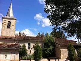
Auterive is a commune in the Gers department in southwestern France.
Geography
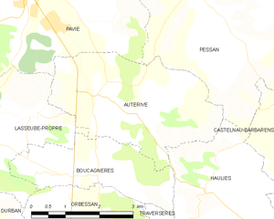
Auterive and its surrounding communes
Population
| Historical population | ||
|---|---|---|
| Year | Pop. | ±% |
| 1962 | 270 | — |
| 1968 | 316 | +17.0% |
| 1975 | 416 | +31.6% |
| 1982 | 469 | +12.7% |
| 1990 | 490 | +4.5% |
| 1999 | 508 | +3.7% |
| 2008 | 530 | +4.3% |
| 2015 | 527 | −0.6% |
See also
References
| Wikimedia Commons has media related to Auterrive (Gers). |
This article is issued from
Wikipedia.
The text is licensed under Creative Commons - Attribution - Sharealike.
Additional terms may apply for the media files.