Castéra-Verduzan
| Castéra-Verduzan | ||
|---|---|---|
| Commune | ||
| ||
 Castéra-Verduzan Location within Occitanie region  Castéra-Verduzan | ||
| Coordinates: 43°48′19″N 0°25′53″E / 43.8053°N 0.4314°ECoordinates: 43°48′19″N 0°25′53″E / 43.8053°N 0.4314°E | ||
| Country | France | |
| Region | Occitanie | |
| Department | Gers | |
| Arrondissement | Auch | |
| Canton | Baïse-Armagnac | |
| Intercommunality | Cœur de Gascogne | |
| Government | ||
| • Mayor (2008–2014) | Jean-Michel Garcia | |
| Area1 | 19.82 km2 (7.65 sq mi) | |
| Population (2008)2 | 925 | |
| • Density | 47/km2 (120/sq mi) | |
| Time zone | UTC+1 (CET) | |
| • Summer (DST) | UTC+2 (CEST) | |
| INSEE/Postal code | 32083 /32410 | |
| Elevation |
97–221 m (318–725 ft) (avg. 119 m or 390 ft) | |
|
1 French Land Register data, which excludes lakes, ponds, glaciers > 1 km2 (0.386 sq mi or 247 acres) and river estuaries. 2 Population without double counting: residents of multiple communes (e.g., students and military personnel) only counted once. | ||
.svg.png)
Castéra-Verduzan is a commune in the Gers department in southwestern France.
Geography
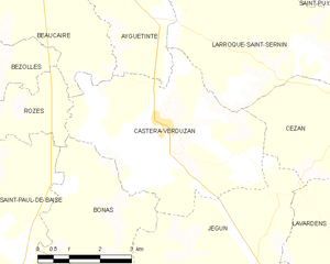
Castéra-Verduzan and its surrounding communes
Population
| Historical population | ||
|---|---|---|
| Year | Pop. | ±% |
| 1962 | 682 | — |
| 1968 | 738 | +8.2% |
| 1975 | 719 | −2.6% |
| 1982 | 753 | +4.7% |
| 1990 | 794 | +5.4% |
| 1999 | 830 | +4.5% |
| 2008 | 925 | +11.4% |
See also
References
| Wikimedia Commons has media related to Castéra-Verduzan. |
| Authority control |
|---|
I
This article is issued from
Wikipedia.
The text is licensed under Creative Commons - Attribution - Sharealike.
Additional terms may apply for the media files.