Larressingle
| Larressingle | |
|---|---|
| Commune | |
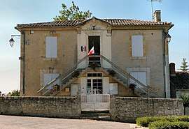 Town hall | |
 Larressingle Location within Occitanie region  Larressingle | |
| Coordinates: 43°56′45″N 0°18′40″E / 43.9458°N 0.3111°ECoordinates: 43°56′45″N 0°18′40″E / 43.9458°N 0.3111°E | |
| Country | France |
| Region | Occitanie |
| Department | Gers |
| Arrondissement | Condom |
| Canton | Armagnac-Ténarèze |
| Intercommunality | Ténarèze |
| Government | |
| • Mayor (2014-2020) | Xavier Fernandez |
| Area1 | 8.55 km2 (3.30 sq mi) |
| Population (2013)2 | 215 |
| • Density | 25/km2 (65/sq mi) |
| Demonym(s) | Larressinglois |
| Time zone | UTC+1 (CET) |
| • Summer (DST) | UTC+2 (CEST) |
| INSEE/Postal code | 32194 /32100 |
| Elevation | 75–177 m (246–581 ft) |
|
1 French Land Register data, which excludes lakes, ponds, glaciers > 1 km2 (0.386 sq mi or 247 acres) and river estuaries. 2 Population without double counting: residents of multiple communes (e.g., students and military personnel) only counted once. | |
Larressingle is a commune in the Gers department in southwestern France.
Geography

Larressingle and its surrounding communes
Population
| Historical population | ||
|---|---|---|
| Year | Pop. | ±% |
| 1962 | 187 | — |
| 1968 | 170 | −9.1% |
| 1975 | 155 | −8.8% |
| 1982 | 138 | −11.0% |
| 1990 | 161 | +16.7% |
| 1999 | 200 | +24.2% |
| 2008 | 202 | +1.0% |
Sights
- Walls
- Port of Artigue
- Castle
- Church of St. Sigismund
- Siege machines
See also
References
| Wikimedia Commons has media related to Larressingle. |
This article is issued from
Wikipedia.
The text is licensed under Creative Commons - Attribution - Sharealike.
Additional terms may apply for the media files.