Gers
| Gers | |||
|---|---|---|---|
| Department | |||
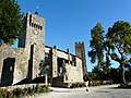
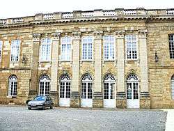 Prefecture building of the Gers department, in Auch | |||
| |||
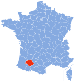 Location of the Gers in France | |||
| Coordinates: 43°39′N 0°35′E / 43.650°N 0.583°ECoordinates: 43°39′N 0°35′E / 43.650°N 0.583°E | |||
| Country | France | ||
| Region | Occitanie | ||
| Prefecture | Auch | ||
| Subprefectures |
Condom Mirande | ||
| Government | |||
| • President of the General Council | Jean-Pierre Pujol (PS) | ||
| Area1 | |||
| • Total | 6,257 km2 (2,416 sq mi) | ||
| Population (2013) | |||
| • Total | 190,276 | ||
| • Rank | 90th | ||
| • Density | 30/km2 (79/sq mi) | ||
| Time zone | UTC+1 (CET) | ||
| • Summer (DST) | UTC+2 (CEST) | ||
| Department number | 32 | ||
| Arrondissements | 3 | ||
| Cantons | 17 | ||
| Communes | 462 | ||
| ^1 French Land Register data, which exclude estuaries, and lakes, ponds, and glaciers larger than 1 km2 | |||


The Gers (French: [ʒɛʁ(s)], Occitan: [dʒɛɾs]) is a department in the Occitanie region in the southwest of France[1] named after the Gers River.
Inhabitants are called les Gersois.
History
In the Middle Ages, the Lordship of L'Isle-Jourdain was nearby.
The Gers is one of the original 83 departments created during the French Revolution on 4 March 1790. It was created from parts of the former provinces of Guyenne and Gascony.
In 1808 it lost Lavit on its north-eastern side to the newly created department of Tarn-et-Garonne.
Culture
The culture is largely agricultural, with great emphasis on the local gastronomical specialties such as:
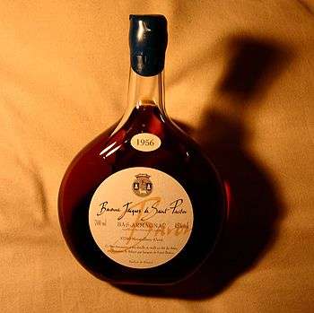
- Armagnac brandy,[1]
- Côtes de Gascogne,
- Floc de Gascogne,
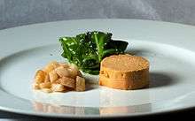
- Foie gras,
- wild mushrooms.
Also, some prominent cultivated crops are corn, colza, sunflowers and grain.
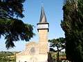
The Gascon language is a dialect of Occitan, but it is not widely spoken. The department is characterised by sleepy bastide villages and rolling hills with the Pyrenees visible to the south.
Alexandre Dumas, père created the famous Gersois d'Artagnan, the fourth musketeer of The Three Musketeers. A museum to d'Artagnan is found in the Gersois village of Lupiac.
A horse race at the Auteuil Hippodrome has been named after André Boingnères, a notable local race-horse owner and the successful mayor of Termes-d'Armagnac between 1951 and 1976.
Politics
The President of the General Council is Philippe Martin of the Socialist Party.
| Party | seats | |
|---|---|---|
| • | Socialist Party | 17 |
| Union for a Popular Movement | 9 | |
| • | French Communist Party | 3 |
| • | Miscellaneous Left | 1 |
| Miscellaneous Right | 1 | |
Geography and demography
Located in southwestern France, the Gers is part of the Occitanie region. It is surrounded by the departments of Hautes-Pyrénées, Haute-Garonne, Tarn-et-Garonne, Lot-et-Garonne, Landes, and Pyrénées-Atlantiques. The Gers is often referred to as amongst the least densely populated, or most rural, areas in all of Western Europe.
List of the 10 most important cities of the département:
| # | Municipality | Population (2016) |
|---|---|---|
| 1 | Auch | 21 911 |
| 2 | L'Isle-Jourdain | 8 012 |
| 3 | Condom | 7 003 |
| 4 | Fleurance | 6 280 |
| 5 | Lectoure | 3 730 |
| 6 | Eauze | 3 877 |
| 7 | Mirande | 3 572 |
| 8 | Vic-Fezensac | 3 563 |
| 9 | Gimont | 2 871 |
| 10 | Pavie | 2 426 |
Climate
The annual rain varies from more than 900 mm in the south-west of the department, to less than 700 mm in the North-East (Auch, Condom, Lectoure).
The winters vary, with only occasional freezing temperatures, but the climate remains mild and dry. The amount of sunshine is about 1950 hours/years.
The summers are hot and dry. Auch is, together with Toulouse, Nîmes, Carpentras, Ajaccio, Marseille, Toulon and Perpignan, one of the hottest cities in France.
Tourism
According to recent data tourism represents annually:
- 610 000 tourists,
- 5.900.000 nights,
- 22.100 commercial beds,
- 2 400 paid employment related to tourism,
- the tourist represent an equivalent of 17.100 permanent inhabitants,
- their estimated expenditure is 141.000.000 €.
References
- 1 2

See also
External links
| Wikisource has the text of the 1879 American Cyclopædia article Gers. |
- (in French) General Council website
- (in French) Prefecture website
- Welcome to the Gers in Gascony http://www.tourisme-gers.com