Labarthète
| Labarthète | |
|---|---|
| Commune | |
 Labarthète Location within Occitanie region  Labarthète | |
| Coordinates: 43°37′50″N 0°09′19″W / 43.6306°N 0.1553°WCoordinates: 43°37′50″N 0°09′19″W / 43.6306°N 0.1553°W | |
| Country | France |
| Region | Occitanie |
| Department | Gers |
| Arrondissement | Mirande |
| Canton | Adour-Gersoise |
| Intercommunality | Monts et vallées de l'Adour |
| Government | |
| • Mayor (2014–2020) | Philippe Dufau |
| Area1 | 11.09 km2 (4.28 sq mi) |
| Population (2013)2 | 143 |
| • Density | 13/km2 (33/sq mi) |
| Time zone | UTC+1 (CET) |
| • Summer (DST) | UTC+2 (CEST) |
| INSEE/Postal code | 32170 /32400 |
| Elevation |
99–233 m (325–764 ft) (avg. 210 m or 690 ft) |
|
1 French Land Register data, which excludes lakes, ponds, glaciers > 1 km2 (0.386 sq mi or 247 acres) and river estuaries. 2 Population without double counting: residents of multiple communes (e.g., students and military personnel) only counted once. | |
Labarthète is a commune in the Gers département in southwestern France.
Geography
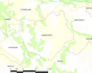
Labarthète and its surrounding communes
Population
| Historical population | ||
|---|---|---|
| Year | Pop. | ±% |
| 1962 | 198 | — |
| 1968 | 205 | +3.5% |
| 1975 | 151 | −26.3% |
| 1982 | 154 | +2.0% |
| 1990 | 150 | −2.6% |
| 1999 | 137 | −8.7% |
| 2005 | 142 | +3.6% |
| 2010 | 147 | +3.5% |
| 2013 | 143 | −2.7% |
See also
References
| Wikimedia Commons has media related to Labarthète. |
| Authority control |
|---|
This article is issued from
Wikipedia.
The text is licensed under Creative Commons - Attribution - Sharealike.
Additional terms may apply for the media files.