Dému
| Dému | ||
|---|---|---|
| Commune | ||
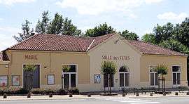 Town hall | ||
| ||
 Dému Location within Occitanie region  Dému | ||
| Coordinates: 43°45′59″N 0°10′02″E / 43.7664°N 0.1672°ECoordinates: 43°45′59″N 0°10′02″E / 43.7664°N 0.1672°E | ||
| Country | France | |
| Region | Occitanie | |
| Department | Gers | |
| Arrondissement | Condom | |
| Canton | Fezensac | |
| Intercommunality | Artagnan en Fézensac | |
| Government | ||
| • Mayor (2008–2014) | Danièle Barthélemy | |
| Area1 | 28.89 km2 (11.15 sq mi) | |
| Population (2008)2 | 332 | |
| • Density | 11/km2 (30/sq mi) | |
| Time zone | UTC+1 (CET) | |
| • Summer (DST) | UTC+2 (CEST) | |
| INSEE/Postal code | 32115 /32190 | |
| Elevation |
137–232 m (449–761 ft) (avg. 171 m or 561 ft) | |
|
1 French Land Register data, which excludes lakes, ponds, glaciers > 1 km2 (0.386 sq mi or 247 acres) and river estuaries. 2 Population without double counting: residents of multiple communes (e.g., students and military personnel) only counted once. | ||
.svg.png)
Dému is a commune in the Gers department in southwestern France.
Geography
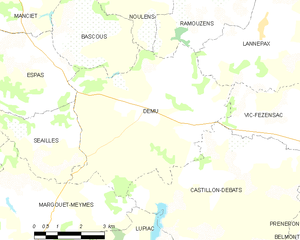
Dému and its surrounding communes
Population
| Historical population | ||
|---|---|---|
| Year | Pop. | ±% |
| 1962 | 456 | — |
| 1968 | 403 | −11.6% |
| 1975 | 372 | −7.7% |
| 1982 | 314 | −15.6% |
| 1990 | 325 | +3.5% |
| 1999 | 339 | +4.3% |
| 2008 | 332 | −2.1% |
Literature
Dému features as a main setting in the Michael Ondaatje novel Divisadero.
See also
References
| Wikimedia Commons has media related to Dému. |
This article is issued from
Wikipedia.
The text is licensed under Creative Commons - Attribution - Sharealike.
Additional terms may apply for the media files.