Monbrun
| Monbrun | |
|---|---|
| Commune | |
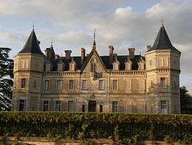 Chateau | |
 Monbrun Location within Occitanie region  Monbrun | |
| Coordinates: 43°39′47″N 1°01′32″E / 43.6631°N 1.0256°ECoordinates: 43°39′47″N 1°01′32″E / 43.6631°N 1.0256°E | |
| Country | France |
| Region | Occitanie |
| Department | Gers |
| Arrondissement | Condom |
| Canton | Gimone-Arrats |
| Intercommunality | Terride-Arcadèche |
| Government | |
| • Mayor (2008–2014) | Thierry Puech |
| Area1 | 10.8 km2 (4.2 sq mi) |
| Population (2008)2 | 324 |
| • Density | 30/km2 (78/sq mi) |
| Time zone | UTC+1 (CET) |
| • Summer (DST) | UTC+2 (CEST) |
| INSEE/Postal code | 32262 /32600 |
| Elevation |
158–225 m (518–738 ft) (avg. 230 m or 750 ft) |
|
1 French Land Register data, which excludes lakes, ponds, glaciers > 1 km2 (0.386 sq mi or 247 acres) and river estuaries. 2 Population without double counting: residents of multiple communes (e.g., students and military personnel) only counted once. | |
Monbrun is a commune in the Gers department in southwestern France.
Geography
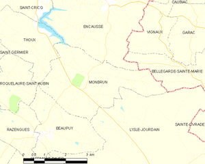
Monbrun and its surrounding communes
Population
| Historical population | ||
|---|---|---|
| Year | Pop. | ±% |
| 1962 | 243 | — |
| 1968 | 238 | −2.1% |
| 1975 | 180 | −24.4% |
| 1982 | 198 | +10.0% |
| 1990 | 176 | −11.1% |
| 1999 | 214 | +21.6% |
| 2008 | 324 | +51.4% |
See also
References
| Wikimedia Commons has media related to Monbrun. |
| Authority control |
|---|
This article is issued from
Wikipedia.
The text is licensed under Creative Commons - Attribution - Sharealike.
Additional terms may apply for the media files.