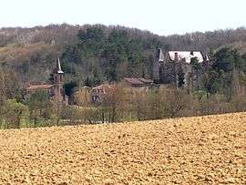
Monclar-sur-Losse
| Monclar-sur-Losse | |
|---|---|
| Commune | |
 | |
 Monclar-sur-Losse Location within Occitanie region  Monclar-sur-Losse | |
| Coordinates: 43°31′57″N 0°20′02″E / 43.5325°N 0.3339°ECoordinates: 43°31′57″N 0°20′02″E / 43.5325°N 0.3339°E | |
| Country | France |
| Region | Occitanie |
| Department | Gers |
| Arrondissement | Mirande |
| Canton | Pardiac-Rivière-Basse |
| Intercommunality | Cœur d'Astarac en Gascogne |
| Government | |
| • Mayor (2008–2014) | Gérard Pérez |
| Area1 | 10.47 km2 (4.04 sq mi) |
| Population (2008)2 | 126 |
| • Density | 12/km2 (31/sq mi) |
| Time zone | UTC+1 (CET) |
| • Summer (DST) | UTC+2 (CEST) |
| INSEE/Postal code | 32265 /32300 |
| Elevation |
164–267 m (538–876 ft) (avg. 169 m or 554 ft) |
|
1 French Land Register data, which excludes lakes, ponds, glaciers > 1 km2 (0.386 sq mi or 247 acres) and river estuaries. 2 Population without double counting: residents of multiple communes (e.g., students and military personnel) only counted once. | |
Monclar-sur-Losse is a commune in the Gers department in southwestern France.
Geography
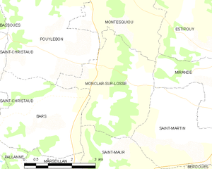
Monclar-sur-Losse and its surrounding communes
Population
| Historical population | ||
|---|---|---|
| Year | Pop. | ±% |
| 1962 | 141 | — |
| 1968 | 118 | −16.3% |
| 1975 | 113 | −4.2% |
| 1982 | 126 | +11.5% |
| 1990 | 125 | −0.8% |
| 1999 | 102 | −18.4% |
| 2008 | 126 | +23.5% |
See also
References
| Wikimedia Commons has media related to Monclar-sur-Losse. |
This article is issued from
Wikipedia.
The text is licensed under Creative Commons - Attribution - Sharealike.
Additional terms may apply for the media files.