Miradoux
| Miradoux | ||
|---|---|---|
| Commune | ||
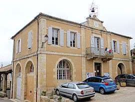 Town hall | ||
| ||
 Miradoux Location within Occitanie region  Miradoux | ||
| Coordinates: 43°59′56″N 0°45′24″E / 43.9989°N 0.7567°ECoordinates: 43°59′56″N 0°45′24″E / 43.9989°N 0.7567°E | ||
| Country | France | |
| Region | Occitanie | |
| Department | Gers | |
| Arrondissement | Condom | |
| Canton | Lectoure-Lomagne | |
| Intercommunality | Lomagne Gersoise | |
| Government | ||
| • Mayor (2008–2014) | Suzanne Macabiau | |
| Area1 | 34.58 km2 (13.35 sq mi) | |
| Population (2008)2 | 530 | |
| • Density | 15/km2 (40/sq mi) | |
| Time zone | UTC+1 (CET) | |
| • Summer (DST) | UTC+2 (CEST) | |
| INSEE/Postal code | 32253 /32340 | |
| Elevation | 79–227 m (259–745 ft) | |
|
1 French Land Register data, which excludes lakes, ponds, glaciers > 1 km2 (0.386 sq mi or 247 acres) and river estuaries. 2 Population without double counting: residents of multiple communes (e.g., students and military personnel) only counted once. | ||
.svg.png)
Miradoux is a commune in the Gers department in southwestern France.
Geography
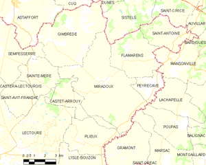
Miradoux and its surrounding communes
The river Auroue forms most of the commune's western border and the Arrats all of its southeastern border.
Population
| Historical population | ||
|---|---|---|
| Year | Pop. | ±% |
| 1962 | 619 | — |
| 1968 | 728 | +17.6% |
| 1975 | 654 | −10.2% |
| 1982 | 647 | −1.1% |
| 1990 | 594 | −8.2% |
| 1999 | 497 | −16.3% |
| 2008 | 530 | +6.6% |
See also
References
| Wikimedia Commons has media related to Miradoux. |
This article is issued from
Wikipedia.
The text is licensed under Creative Commons - Attribution - Sharealike.
Additional terms may apply for the media files.