Mansencôme
| Mansencôme | |
|---|---|
| Commune | |
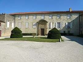 Château du Busca in Mansencôme | |
 Mansencôme Location within Occitanie region  Mansencôme | |
| Coordinates: 43°52′20″N 0°20′26″E / 43.8722°N 0.3406°ECoordinates: 43°52′20″N 0°20′26″E / 43.8722°N 0.3406°E | |
| Country | France |
| Region | Occitanie |
| Department | Gers |
| Arrondissement | Condom |
| Canton | Armagnac-Ténarèze |
| Intercommunality | Ténarèze |
| Government | |
| • Mayor (2008–2014) | Etienne Barrère |
| Area1 | 4.05 km2 (1.56 sq mi) |
| Population (2008)2 | 67 |
| • Density | 17/km2 (43/sq mi) |
| Time zone | UTC+1 (CET) |
| • Summer (DST) | UTC+2 (CEST) |
| INSEE/Postal code | 32230 /32310 |
| Elevation |
112–201 m (367–659 ft) (avg. 200 m or 660 ft) |
|
1 French Land Register data, which excludes lakes, ponds, glaciers > 1 km2 (0.386 sq mi or 247 acres) and river estuaries. 2 Population without double counting: residents of multiple communes (e.g., students and military personnel) only counted once. | |
Mansencôme is a commune in the Gers department in southwestern France.
Geography
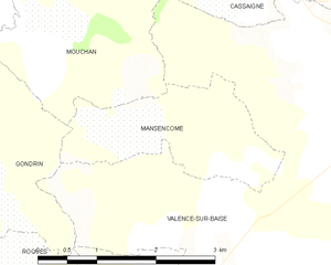
Mansencôme and its surrounding communes
Population
| Historical population | ||
|---|---|---|
| Year | Pop. | ±% |
| 1962 | 110 | — |
| 1968 | 93 | −15.5% |
| 1975 | 88 | −5.4% |
| 1982 | 71 | −19.3% |
| 1990 | 69 | −2.8% |
| 1999 | 73 | +5.8% |
| 2008 | 67 | −8.2% |
See also
References
| Wikimedia Commons has media related to Mansencôme. |
This article is issued from
Wikipedia.
The text is licensed under Creative Commons - Attribution - Sharealike.
Additional terms may apply for the media files.