Saint-Puy
| Saint-Puy | ||
|---|---|---|
| Commune | ||
 | ||
| ||
 Saint-Puy Location within Occitanie region  Saint-Puy | ||
| Coordinates: 43°52′38″N 0°27′47″E / 43.8772°N 0.4631°ECoordinates: 43°52′38″N 0°27′47″E / 43.8772°N 0.4631°E | ||
| Country | France | |
| Region | Occitanie | |
| Department | Gers | |
| Arrondissement | Condom | |
| Canton | Baïse-Armagnac | |
| Government | ||
| • Mayor (2008–2014) | Michel Labatut | |
| Area1 | 36.88 km2 (14.24 sq mi) | |
| Population (2008)2 | 572 | |
| • Density | 16/km2 (40/sq mi) | |
| Time zone | UTC+1 (CET) | |
| • Summer (DST) | UTC+2 (CEST) | |
| INSEE/Postal code | 32404 /32310 | |
| Elevation |
87–220 m (285–722 ft) (avg. 160 m or 520 ft) | |
|
1 French Land Register data, which excludes lakes, ponds, glaciers > 1 km2 (0.386 sq mi or 247 acres) and river estuaries. 2 Population without double counting: residents of multiple communes (e.g., students and military personnel) only counted once. | ||
.svg.png)
Saint-Puy is a commune in the Gers department in southwestern France.
Geography
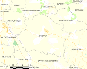
Saint-Puy and its surrounding communes
Population
| Historical population | ||
|---|---|---|
| Year | Pop. | ±% |
| 1962 | 836 | — |
| 1968 | 748 | −10.5% |
| 1975 | 669 | −10.6% |
| 1982 | 601 | −10.2% |
| 1990 | 595 | −1.0% |
| 1999 | 603 | +1.3% |
| 2008 | 572 | −5.1% |
Notable people
Saint-Puy was the home of the gentleman soldier Blaise de Monluc.
See also
References
| Wikimedia Commons has media related to Saint-Puy. |
This article is issued from
Wikipedia.
The text is licensed under Creative Commons - Attribution - Sharealike.
Additional terms may apply for the media files.