Auradé
| Auradé | ||
|---|---|---|
| Commune | ||
| ||
 Auradé Location within Occitanie region  Auradé | ||
| Coordinates: 43°34′02″N 1°03′30″E / 43.5672°N 1.0583°ECoordinates: 43°34′02″N 1°03′30″E / 43.5672°N 1.0583°E | ||
| Country | France | |
| Region | Occitanie | |
| Department | Gers | |
| Arrondissement | Auch | |
| Canton | L'Isle-Jourdain | |
| Intercommunality | CC Gascogne Toulousaine | |
| Government | ||
| • Mayor (2014-2020) | Francis Larroque | |
| Area1 | 21.32 km2 (8.23 sq mi) | |
| Population (2015)2 | 671 | |
| • Density | 31/km2 (82/sq mi) | |
| Time zone | UTC+1 (CET) | |
| • Summer (DST) | UTC+2 (CEST) | |
| INSEE/Postal code | 32016 /32600 | |
| Elevation |
143–311 m (469–1,020 ft) (avg. 162 m or 531 ft) | |
|
1 French Land Register data, which excludes lakes, ponds, glaciers > 1 km2 (0.386 sq mi or 247 acres) and river estuaries. 2 Population without double counting: residents of multiple communes (e.g., students and military personnel) only counted once. | ||
.svg.png)
Auradé is a commune in the Gers department in southwestern France.
Geography
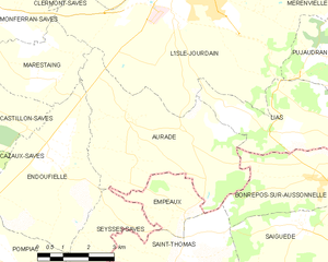
Auradé and its surrounding communes
Population
| Historical population | ||
|---|---|---|
| Year | Pop. | ±% |
| 1962 | 278 | — |
| 1968 | 318 | +14.4% |
| 1975 | 320 | +0.6% |
| 1982 | 329 | +2.8% |
| 1990 | 322 | −2.1% |
| 1999 | 388 | +20.5% |
| 2008 | 580 | +49.5% |
| 2015 | 671 | +15.7% |
See also
References
| Wikimedia Commons has media related to Auradé. |
This article is issued from
Wikipedia.
The text is licensed under Creative Commons - Attribution - Sharealike.
Additional terms may apply for the media files.