Mont-d'Astarac
| Mont-d'Astarac | |
|---|---|
| Commune | |
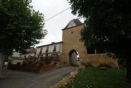 Restored gate and tower | |
 Mont-d'Astarac Location within Occitanie region  Mont-d'Astarac | |
| Coordinates: 43°19′45″N 0°34′08″E / 43.3292°N 0.5689°ECoordinates: 43°19′45″N 0°34′08″E / 43.3292°N 0.5689°E | |
| Country | France |
| Region | Occitanie |
| Department | Gers |
| Arrondissement | Mirande |
| Canton | Astarac-Gimone |
| Government | |
| • Mayor (2008–2014) | Françoise Casale |
| Area1 | 8.05 km2 (3.11 sq mi) |
| Population (2008)2 | 96 |
| • Density | 12/km2 (31/sq mi) |
| Time zone | UTC+1 (CET) |
| • Summer (DST) | UTC+2 (CEST) |
| INSEE/Postal code | 32280 /32140 |
| Elevation |
234–386 m (768–1,266 ft) (avg. 349 m or 1,145 ft) |
|
1 French Land Register data, which excludes lakes, ponds, glaciers > 1 km2 (0.386 sq mi or 247 acres) and river estuaries. 2 Population without double counting: residents of multiple communes (e.g., students and military personnel) only counted once. | |
Mont-d'Astarac is a commune in the Gers department in southwestern France.
Geography

Mont-d'Astarac and its surrounding communes
History

The innerside of the gate.
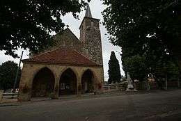
The church.
_%C3%A9glise_St_Laurent_de_Mont_d'Astarac.jpg)
Interior of the church including murals.
Its history goes back up in the years 930, when it became the first capital of Astarac. Indeed, it is on the still visible feudal clod this day that was Arnaud Garcia's castle which becomes established there having inherited the County of Astarac of hisfather Count de Gascogne, Garcia Sanche says the Bent - defer small son of the count of Castille- To see for its monuments - tower, and church - registered on the Historic Monuments of France and for its very beautiful murals dating the 15th century.[1]
Population
| Historical population | ||
|---|---|---|
| Year | Pop. | ±% |
| 1962 | 132 | — |
| 1968 | 122 | −7.6% |
| 1975 | 107 | −12.3% |
| 1982 | 112 | +4.7% |
| 1990 | 103 | −8.0% |
| 1999 | 102 | −1.0% |
| 2008 | 96 | −5.9% |
See also
References
| Wikimedia Commons has media related to Mont-d'Astarac. |
| Authority control |
|---|
This article is issued from
Wikipedia.
The text is licensed under Creative Commons - Attribution - Sharealike.
Additional terms may apply for the media files.