Edna, Kansas
| Edna, Kansas | |
|---|---|
| City | |
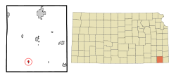 Location within Labette County and Kansas | |
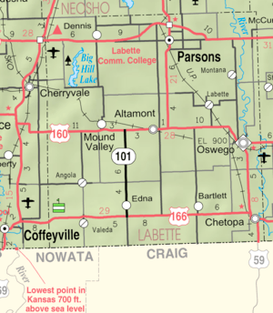 KDOT map of Labette County (legend) | |
| Coordinates: 37°3′34″N 95°21′31″W / 37.05944°N 95.35861°WCoordinates: 37°3′34″N 95°21′31″W / 37.05944°N 95.35861°W | |
| Country | United States |
| State | Kansas |
| County | Labette |
| Area[1] | |
| • Total | 0.36 sq mi (0.93 km2) |
| • Land | 0.36 sq mi (0.93 km2) |
| • Water | 0 sq mi (0 km2) |
| Elevation | 978 ft (298 m) |
| Population (2010)[2] | |
| • Total | 442 |
| • Estimate (2016)[3] | 414 |
| • Density | 1,200/sq mi (480/km2) |
| Time zone | UTC-6 (Central (CST)) |
| • Summer (DST) | UTC-5 (CDT) |
| ZIP code | 67342 |
| Area code(s) | 620 |
| FIPS code | 20-19900[4] |
| GNIS feature ID | 0469311[5] |
Edna is a city in Labette County, Kansas, United States. As of the 2010 census, the city population was 442.[6]
History
The first store in Edna opened in 1876.[7] The first post office in Edna was established in April 1878.[8] The town of Edna was platted in the summer of 1886 when the railroad was extended to that point.[9]
Edna was named in 1876 for a child, Edna Gragory.[10]
Geography
Edna is located at 37°3′34″N 95°21′31″W / 37.05944°N 95.35861°W (37.059524, -95.358583).[11] According to the United States Census Bureau, the city has a total area of 0.36 square miles (0.93 km2), all land.[1]
Climate
The climate in this area is characterized by hot, humid summers and generally mild to cool winters. According to the Köppen Climate Classification system, Edna has a humid subtropical climate, abbreviated "Cfa" on climate maps.[12]
Demographics
| Historical population | |||
|---|---|---|---|
| Census | Pop. | %± | |
| 1880 | 26 | — | |
| 1890 | 321 | 1,134.6% | |
| 1900 | 374 | 16.5% | |
| 1910 | 489 | 30.7% | |
| 1920 | 500 | 2.2% | |
| 1930 | 502 | 0.4% | |
| 1940 | 507 | 1.0% | |
| 1950 | 422 | −16.8% | |
| 1960 | 442 | 4.7% | |
| 1970 | 418 | −5.4% | |
| 1980 | 537 | 28.5% | |
| 1990 | 438 | −18.4% | |
| 2000 | 423 | −3.4% | |
| 2010 | 442 | 4.5% | |
| Est. 2016 | 414 | [3] | −6.3% |
| U.S. Decennial Census | |||
2010 census
As of the census[2] of 2010, there were 442 people, 183 households, and 122 families residing in the city. The population density was 1,227.8 inhabitants per square mile (474.1/km2). There were 219 housing units at an average density of 608.3 per square mile (234.9/km2). The racial makeup of the city was 88.7% White, 3.4% Native American, 0.9% from other races, and 7.0% from two or more races. Hispanic or Latino of any race were 2.3% of the population.
There were 183 households of which 33.3% had children under the age of 18 living with them, 53.6% were married couples living together, 10.9% had a female householder with no husband present, 2.2% had a male householder with no wife present, and 33.3% were non-families. 32.2% of all households were made up of individuals and 18.1% had someone living alone who was 65 years of age or older. The average household size was 2.42 and the average family size was 3.04.
The median age in the city was 39.7 years. 25.3% of residents were under the age of 18; 10.2% were between the ages of 18 and 24; 19.8% were from 25 to 44; 27.3% were from 45 to 64; and 17.4% were 65 years of age or older. The gender makeup of the city was 49.1% male and 50.9% female.
2000 census
As of the census[4] of 2000, there were 423 people, 191 households, and 123 families residing in the city. The population density was 1,065.6 people per square mile (408.3/km²). There were 214 housing units at an average density of 539.1 per square mile (206.6/km²). The racial makeup of the city was 90.07% White, 0.24% African American, 5.20% Native American, 0.24% Asian, 0.47% from other races, and 3.78% from two or more races. Hispanic or Latino of any race were 0.95% of the population.
There were 191 households out of which 28.8% had children under the age of 18 living with them, 47.6% were married couples living together, 13.1% had a female householder with no husband present, and 35.6% were non-families. 34.0% of all households were made up of individuals and 25.1% had someone living alone who was 65 years of age or older. The average household size was 2.21 and the average family size was 2.79.
In the city, the population was spread out with 27.9% under the age of 18, 4.0% from 18 to 24, 23.4% from 25 to 44, 21.7% from 45 to 64, and 22.9% who were 65 years of age or older. The median age was 42 years. For every 100 females, there were 79.2 males. For every 100 females age 18 and over, there were 77.3 males.
The median income for a household in the city was $27,250, and the median income for a family was $34,205. Males had a median income of $28,438 versus $21,563 for females. The per capita income for the city was $18,694. About 1.7% of families and 6.3% of the population were below the poverty line, including 5.2% of those under age 18 and 18.1% of those age 65 or over.
Education
Edna is served by USD 506 Labette County.[13]
Edna High School was closed through school unification. The Edna High School mascot was Pirates.[14]
References
- 1 2 "US Gazetteer files 2010". United States Census Bureau. Archived from the original on 2012-01-24. Retrieved 2012-07-06.
- 1 2 "American FactFinder". United States Census Bureau. Retrieved 2012-07-06.
- 1 2 "Population and Housing Unit Estimates". Retrieved June 9, 2017.
- 1 2 "American FactFinder". United States Census Bureau. Archived from the original on 2013-09-11. Retrieved 2008-01-31.
- ↑ "US Board on Geographic Names". United States Geological Survey. 2007-10-25. Retrieved 2008-01-31.
- ↑ "2010 City Population and Housing Occupancy Status". U.S. Census Bureau. Archived from the original on July 21, 2011. Retrieved March 18, 2012.
- ↑ Blackmar, Frank Wilson (1912). Kansas: A Cyclopedia of State History, Embracing Events, Institutions, Industries, Counties, Cities, Towns, Prominent Persons, Etc. Standard Publishing Company. p. 563.
- ↑ "Kansas Post Offices, 1828-1961". Kansas Historical Society. Retrieved 12 June 2014.
- ↑ Case, Nelson (1893). History of Labette County, Kansas: From the First Settlement to the Close of 1892. Crane & Company. p. 138.
- ↑ Gannett, Henry (1905). The Origin of Certain Place Names in the United States. Govt. Print. Off. p. 115.
- ↑ "US Gazetteer files: 2010, 2000, and 1990". United States Census Bureau. 2011-02-12. Retrieved 2011-04-23.
- ↑ Climate Summary for Edna, Kansas
- ↑ "USD 506 Labette County". USD 506. Retrieved 10 January 2017.
- ↑ "Edna High School". E-YEARBOOK.COM. Retrieved 10 January 2017.
Further reading
- Labette County
- History of Labette County, Kansas, and Representative Citizens; Nelson Case; Biographical Publishing Company; 846 pages; 1901. (Download 50MB PDF eBook)
- Kansas
- History of the State of Kansas; William G. Cutler; A.T. Andreas Publisher; 1883. (Online HTML eBook)
- Kansas : A Cyclopedia of State History, Embracing Events, Institutions, Industries, Counties, Cities, Towns, Prominent Persons, Etc; 3 Volumes; Frank W. Blackmar; Standard Publishing Co; 944 / 955 / 824 pages; 1912. (Volume1 - Download 54MB PDF eBook),(Volume2 - Download 53MB PDF eBook), (Volume3 - Download 33MB PDF eBook)
External links
| Wikimedia Commons has media related to Edna, Kansas. |
- City
- Schools
- USD 506, local school district
- Maps
- Edna City Map, KDOT
Municipalities and communities of Labette County, Kansas, United States | ||
|---|---|---|
| Cities |  | |
| Unincorporated communities | ||
| Townships |
| |