Valeda, Kansas
| Valeda, Kansas | |
|---|---|
| Unincorporated community | |
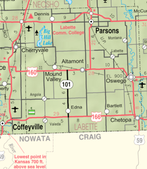 KDOT map of Labette County (legend) | |
 Valeda  Valeda | |
| Coordinates: 37°02′50″N 95°26′51″W / 37.04722°N 95.44750°WCoordinates: 37°02′50″N 95°26′51″W / 37.04722°N 95.44750°W | |
| Country | United States |
| State | Kansas |
| County | Labette |
| Time zone | UTC-6 (CST) |
| • Summer (DST) | UTC-5 (CDT) |
| Area code | 620 |
Valeda is an unincorporated community in Labette County, Kansas, United States.
History
References
- ↑ Blackmar, Frank Wilson (1912). Kansas: A Cyclopedia of State History, Volume 2. Standard Publishing Company. p. 839.
Further reading
External links
Municipalities and communities of Labette County, Kansas, United States | ||
|---|---|---|
| Cities | 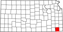 | |
| Unincorporated communities | ||
| Townships |
| |
This article is issued from
Wikipedia.
The text is licensed under Creative Commons - Attribution - Sharealike.
Additional terms may apply for the media files.