Turck, Kansas
| Turck, Kansas | |
|---|---|
| Unincorporated community | |
| Coordinates: 37°15′50″N 94°49′55″W / 37.26389°N 94.83194°WCoordinates: 37°15′50″N 94°49′55″W / 37.26389°N 94.83194°W[1] | |
| Country | United States |
| State | Kansas |
| County | Cherokee |
| Elevation[1] | 932 ft (284 m) |
| Time zone | UTC-6 (CST) |
| • Summer (DST) | UTC-5 (CST) |
| Area code | 620 |
| FIPS code | 20-71650 [1] |
| GNIS feature ID | 0484451 [1] |


Turck is a small unincorporated community located within Cherokee County, Kansas, United States. Its elevation is 932 feet.[1]
History
Turck had a post office from 1889 until 1891.[2]
References
- 1 2 3 4 5 Geographic Names Information System (GNIS) details for Turck, Kansas; United States Geological Survey (USGS); October 13, 1978.
- ↑ "Kansas Post Offices, 1828-1961, page 2". Kansas Historical Society. Retrieved 6 June 2014.
Further reading
- History of Cherokee County, Kansas; Nathanial Allison; Biographical Publishing; 646 pages; 1904. (Download 31MB PDF eBook)
External links
- USD 493, local school district
- Cherokee County Map, KDOT
Municipalities and communities of Cherokee County, Kansas, United States | ||
|---|---|---|
| Cities | 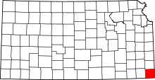 | |
| CDPs | ||
| Unincorporated communities | ||
| Ghost towns | ||
| Townships | ||
| Footnotes | ‡This populated place also has portions in an adjacent county or counties | |
This article is issued from
Wikipedia.
The text is licensed under Creative Commons - Attribution - Sharealike.
Additional terms may apply for the media files.