K-57 (Kansas highway)
| ||||
|---|---|---|---|---|
 | ||||
| Route information | ||||
| Maintained by KDOT | ||||
| Length | 31.200 mi[1] (50.212 km) | |||
| Major junctions | ||||
| South end |
| |||
| North end |
| |||
| Location | ||||
| Counties | Geary, Morris | |||
| Highway system | ||||
| ||||

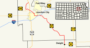
K-57 is a 31.2-mile-long (50.2 km) state highway in the U.S. state of Kansas. It is a north-south highway that connects Junction City to Milford Lake, as well as serving as a southeasterly connection to Council Grove. The highway's mileposts are signed the wrong way; generally the mileage starts at the southern or western terminus. However, the mileposts begin at the northern terminus.
Route description
K-57 begins at US-77 east of Milford Lake, where it heads southwest towards the reservoir. It enters Milford State Park and traverses the dam at the lake. The highway meets a spur of K-244, and turns southeast before meeting K-244. K-57 intersects US-77 once again, and enters Junction City as Jackson Street. It turns east at 18th Street near Junction City Municipal Airport. After traveling east 4 blocks, the highway turns onto Washington Street, where it travels south for a mile (1.6 km) before turning east onto 6th Street and exiting the city. The portion between US-77 and 6th street is also signed as Alternate US-77. K-57 approaches Grandview Plaza, where it crosses the Smoky Hill River at the western city limit. The highway passes through the southern edge of town while paralleling I-70. East of the town, it turns southeast, and passes under I-70 with a diamond interchange. K-57 travels southeast through rural Geary County, winding through the Flint Hills. The highway enters Morris County 2 miles (3.2 km) north of Dwight, and meets its southern terminus in the town at K-4.[2]
History
K-57 first appeared on the map in 1932.[3] The highway was once much longer, and spanned a large portion of eastern Kansas. The southern terminus was at the Missouri border southeast of Pittsburg on what is current-day K-171. Much of the old alignment is now county-owned roads, and after being moved to other, overlapping highways over the years, last appeared on the 2003-2004 map.[4]
Major junctions
| County | Location | mi[1] | km | Destinations | Notes |
|---|---|---|---|---|---|
| Morris | Dwight | 0.000 | 0.000 | Southern terminus; road continues south as K-4 west | |
| Geary | Grandview Plaza | 19.623 | 31.580 | Southern end of US-40 Bus. concurrency; no access to I-70/US-40/K-18 west; I-70 exit 300 | |
| Junction City | 22.126 | 35.608 | Northern end of US-40 Business concurrency | ||
| | 25.785 | 41.497 | Eastern terminus of K-244; southern end of K-244 concurrency | ||
| | 26.151 | 42.086 | Northern end of K-244 concurrency; no southbound access to K-244 west, no northbound access from K-244 east | ||
| | 27.552 | 44.341 | Northern terminus of K-244 Spur | ||
| | 31.200 | 50.212 | Northern terminus | ||
1.000 mi = 1.609 km; 1.000 km = 0.621 mi
| |||||
References
- 1 2 Staff (2016). "Pavement Management Information System". Kansas Department of Transportation. Retrieved April 22, 2017.
- ↑ Kansas Department of Transportation (2015). There's No Place Like Kansas: Official State Transportation Map (PDF) (Map) (2015–16 ed.). Scale not given. Topeka: Kansas Department of Transportation. Retrieved August 12, 2015.
- ↑ State Highway Commission of Kansas (1932). Kansas Official Highway Map (PDF) (Map). Scale not given. Topeka: State Highway Commission of Kansas. Retrieved August 12, 2015.
- ↑ Kansas Department of Transportation (2003). Kansas The Real Experience: Official State Transportation Map (PDF) (Map) (2003–04 ed.). Scale not given. Topeka: Kansas Department of Transportation. Retrieved August 12, 2015.