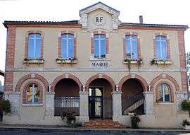
Castelnau-d'Auzan-Labarrère
| Castelnau-d'Auzan-Labarrère | |
|---|---|
| Commune | |
 | |
 Castelnau-d'Auzan-Labarrère Location within Occitanie region  Castelnau-d'Auzan-Labarrère | |
| Coordinates: 43°56′56″N 0°05′06″E / 43.949°N 0.085°ECoordinates: 43°56′56″N 0°05′06″E / 43.949°N 0.085°E | |
| Country | France |
| Region | Occitanie |
| Department | Gers |
| Arrondissement | Condom |
| Canton | Armagnac-Ténarèze |
| Area1 | 56.78 km2 (21.92 sq mi) |
| Population (2013)2 | 1,259 |
| • Density | 22/km2 (57/sq mi) |
| Time zone | UTC+1 (CET) |
| • Summer (DST) | UTC+2 (CEST) |
| INSEE/Postal code | 32079 /32250, 32440 |
|
1 French Land Register data, which excludes lakes, ponds, glaciers > 1 km2 (0.386 sq mi or 247 acres) and river estuaries. 2 Population without double counting: residents of multiple communes (e.g., students and military personnel) only counted once. | |
Castelnau-d'Auzan-Labarrère is a commune in the Gers department of southwestern France. The municipality was established on 1 January 2016 and consists of the former communes of Castelnau-d'Auzan and Labarrère.[1]
Geography
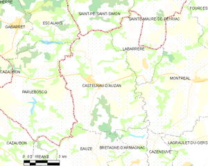
Castelnau-d'Auzan-Labarrère and its surrounding communes
Population
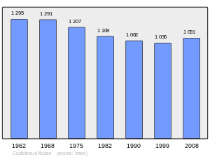
Population 1962-2008
See also
References
| Wikimedia Commons has media related to Castelnau d'Auzan Labarrère. |
- ↑ Arrêté préfectoral 8 December 2015 (in French)
This article is issued from
Wikipedia.
The text is licensed under Creative Commons - Attribution - Sharealike.
Additional terms may apply for the media files.