Bretagne-d'Armagnac
| Bretagne-d'Armagnac | |
|---|---|
| Commune | |
 Bretagne-d'Armagnac Location within Occitanie region  Bretagne-d'Armagnac | |
| Coordinates: 43°53′14″N 0°08′20″E / 43.8872°N 0.1389°ECoordinates: 43°53′14″N 0°08′20″E / 43.8872°N 0.1389°E | |
| Country | France |
| Region | Occitanie |
| Department | Gers |
| Arrondissement | Condom |
| Canton | Armagnac-Ténarèze |
| Government | |
| • Mayor (2008–2014) | Gérard Gourgues |
| Area1 | 12.35 km2 (4.77 sq mi) |
| Population (2008)2 | 388 |
| • Density | 31/km2 (81/sq mi) |
| Time zone | UTC+1 (CET) |
| • Summer (DST) | UTC+2 (CEST) |
| INSEE/Postal code | 32064 /32800 |
| Elevation |
113–185 m (371–607 ft) (avg. 124 m or 407 ft) |
|
1 French Land Register data, which excludes lakes, ponds, glaciers > 1 km2 (0.386 sq mi or 247 acres) and river estuaries. 2 Population without double counting: residents of multiple communes (e.g., students and military personnel) only counted once. | |
Bretagne-d'Armagnac is a commune in the Gers department in southwestern France.
Geography
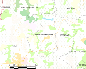
Bretagne-d'Armagnac and its surrounding communes
Population
| Historical population | ||
|---|---|---|
| Year | Pop. | ±% |
| 1962 | 416 | — |
| 1968 | 388 | −6.7% |
| 1975 | 363 | −6.4% |
| 1982 | 392 | +8.0% |
| 1990 | 345 | −12.0% |
| 1999 | 345 | +0.0% |
| 2008 | 388 | +12.5% |
See also
References
| Wikimedia Commons has media related to Bretagne-d'Armagnac. |
This article is issued from
Wikipedia.
The text is licensed under Creative Commons - Attribution - Sharealike.
Additional terms may apply for the media files.