Watauga County, North Carolina
| Watauga County, North Carolina | ||
|---|---|---|
 | ||
| ||
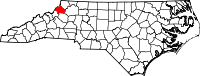 Location in the U.S. state of North Carolina | ||
 North Carolina's location in the U.S. | ||
| Founded | 1849 | |
| Named for | Watauga River | |
| Seat | Boone | |
| Largest town | Boone | |
| Area | ||
| • Total | 312.56 sq mi (810 km2) | |
| • Land | 312.56 sq mi (810 km2) | |
| • Water | 0.9 sq mi (2 km2), 0.3% | |
| Population | ||
| • (2010) | 51,079 | |
| • Density | 163/sq mi (63/km2) | |
| Congressional district | 5th | |
| Time zone | Eastern: UTC−5/−4 | |
| Website |
www | |

Watauga County (/wəˈtɔːɡə/)[1] is a county located in the U.S. state of North Carolina. As of the 2010 census, the population was 51,079.[2] Its county seat and largest town is Boone.[3]
Watauga County comprises the Boone, NC Micropolitan Statistical Area.
History
The county was formed in 1849 from parts of Ashe, Caldwell, Wilkes, and Yancey counties. It was named for the Watauga River, whose name is said to be a Native American word, the translations that range from among them, beautiful water, whispering waters, village of many springs, and river of islands.[4]
In 1861 part of Watauga County was combined with parts of Burke, Caldwell, McDowell, and Yancey counties to form Mitchell County. In 1911, the county was reduced to roughly its current size when portions of it were combined with parts of Caldwell and Mitchell counties were combined to form Avery County.
Geography

According to the U.S. Census Bureau, the county has a total area of 312.56 square miles (809.5 km2), of which 313 square miles (810 km2) is land and 0.9 square miles (2.3 km2) (0.3%) is water.[5]
Watauga County is extremely mountainous, and all of the county's terrain is located within the Appalachian Mountains range. The highest point in the county is Calloway Peak, the highest peak of Grandfather Mountain (shared with the adjacent counties of Avery and Caldwell), which rises to 5,964 feet (1,818 meters) above sea level. At an elevation of 5,506 feet (1,678 meters) above sea level, Beech Mountain is the highest incorporated community east of the Mississippi River. Boone, the county's largest city and county seat, has the highest elevation (3,333 feet) of any city over 10,000 population in the Eastern United States.
Isolated by mountainous terrain from the remainder of North Carolina to the east, Watauga County was described in the 19th and early 20th centuries as one of the Lost Provinces of North Carolina.[6]
Climate
As with most of North Carolina's High Country, the climate of Watauga County is that of a Humid continental climate characterized by considerably cooler and more drastic weather than other parts of the state. Dramatic and unexpected changes in the weather are not uncommon in the county, particularly when it comes to precipitation. This is partly due to the elevation of the county, and partly due to orographic lifting, which causes precipitation to fall more readily in Watauga County than in lowland areas to the east. Summers can be very warm with temperatures commonly in the 80s and on a rare occasion in the 90s. snow usually starts in November, and there can be snow falls in April, although this is not usual. Windy conditions, also, tend to be amplified across the county due to the rugged terrain and high elevation. Many people have noted that the winters of Watauga County tend to resemble those of the northern United States instead of the South.
Because of the cold weather in Watauga County, the area is home to several ski resorts. Among them is Appalachian Ski Mountain.
National protected areas
- Blue Ridge Parkway (part)
- Pisgah National Forest (part)
Demographics
| Historical population | |||
|---|---|---|---|
| Census | Pop. | %± | |
| 1850 | 3,400 | — | |
| 1860 | 4,957 | 45.8% | |
| 1870 | 5,287 | 6.7% | |
| 1880 | 8,160 | 54.3% | |
| 1890 | 10,611 | 30.0% | |
| 1900 | 13,417 | 26.4% | |
| 1910 | 13,556 | 1.0% | |
| 1920 | 13,477 | −0.6% | |
| 1930 | 15,165 | 12.5% | |
| 1940 | 18,114 | 19.4% | |
| 1950 | 18,342 | 1.3% | |
| 1960 | 17,529 | −4.4% | |
| 1970 | 23,404 | 33.5% | |
| 1980 | 31,666 | 35.3% | |
| 1990 | 36,952 | 16.7% | |
| 2000 | 42,695 | 15.5% | |
| 2010 | 51,079 | 19.6% | |
| Est. 2016 | 53,922 | [7] | 5.6% |
| U.S. Decennial Census[8] 1790-1960[9] 1900-1990[10] 1990-2000[11] 2010-2013[2] | |||
As of the census[12] of 2000, there were 42,695 people, 16,540 households, and 9,411 families residing in the county. The population density was 137 people per square mile (53/km²). There were 23,155 housing units at an average density of 74 per square mile (29/km²). The racial makeup of the county was 96.45% White, 1.59% Black or African American, 0.25% Native American, 0.59% Asian, 0.04% Pacific Islander, 0.45% from other races, and 0.62% from two or more races. 1.46% of the population were Hispanics or Latinos of any race.
According to the 2000 Census the largest self-reported ancestry groups in Watauga County were: English (25.1%), German (22.5%) and Irish (13.3%). Most of those claiming Irish ancestry in Watauga county are actually of Scots-Irish/Ulster-Scots Protestant background and not Irish Catholics.
There were 16,540 households out of which 23.20% had children under the age of 18 living with them, 47.40% were married couples living together, 6.80% had a female householder with no husband present, and 43.10% were non-families. 28.60% of all households were made up of individuals and 8.00% had someone living alone who was 65 years of age or older. The average household size was 2.26 and the average family size was 2.80.
The age distribution is 16.30% under the age of 18, 27.80% from 18 to 24, 23.40% from 25 to 44, 21.50% from 45 to 64, and 11.00% who were 65 years of age or older. The median age was 30 years. The overall age distribution and median age are greatly affected by the presence of Appalachian State University in Boone. For every 100 females there are 99.30 males. For every 100 females age 18 and over, there were 98.20 males.
The median income for a household in the county was $32,611, and the median income for a family was $45,508. Males had a median income of $29,135 versus $22,006 for females. The per capita income for the county was $17,258. About 7.20% of families and 17.90% of the population were below the poverty line, including 11.50% of those under age 18 and 10.60% of those age 65 or over.
Communities
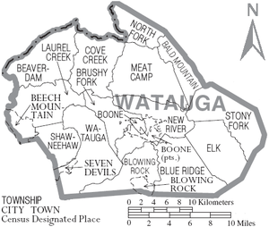
Towns
- Beech Mountain
- Blowing Rock
- Boone (county seat)
- Seven Devils
Unincorporated communities
- Aho
- Bamboo
- Deep Gap
- Foscoe
- Matney
- Meat Camp
- Sherwood
- Shulls Mill
- Sugar Grove
- Valle Crucis
- Vilas
- Zionville
Townships
- Bald Mountain
- Beaverdam
- Blowing Rock
- Blue Ridge
- Boone
- Brushy Fork
- Cove Creek
- Bethel
- Deep Gap
- Meat Camp
- New River
- North Fork
- Shawneehaw
- Stony Fork
- Todd
Economy
- The county produces heavy amounts of Fraser Fir Christmas Trees
- The growth of produce was once a mainstay in the agricultural economy of the county. Cabbage was once widely grown, so much so, that a sauerkraut plant was once located in Boone. The plant has long been closed. Boone Creek, the main creek that runs through Boone and the Appalachian State University campus is still nicknamed Kraut Creek since it is said that the creek used to smell of sauerkraut juice coming out of the plant.
- The Watauga County Farmers' Market has been operating in Boone since 1974.
Politics, law and government
Historically, Watauga's strong Unionist sympathies – though not as strong as high-mountain counties like Avery and Mitchell or counties with Quaker, antislavery histories like Yadkin[13] – meant the county would vote Republican except in Presidential landslides. The only Democrats to gain an absolute majority of the county's vote in the twentieth century were Franklin Roosevelt in 1932 and 1936, and by a very narrow margin, Lyndon B. Johnson in 1964, whilst Woodrow Wilson in 1912 and Bill Clinton in 1992 obtained pluralities in three-cornered contests. The growth of Appalachian State University has, however, turned Watauga into a very competitive swing county, with Barack Obama and Hillary Clinton carrying the county in 2008 and 2016. The county has proved favorable for Libertarians, with Watauga being Gary Johnson's best county in all of North Carolina in both his 2012 and 2016 campaigns.
| Year | Republican | Democratic | Third parties |
|---|---|---|---|
| 2016 | 45.7% 13,697 | 47.2% 14,138 | 7.2% 2,150 |
| 2012 | 50.1% 13,861 | 47.0% 13,002 | 2.9% 811 |
| 2008 | 47.0% 13,344 | 51.3% 14,558 | 1.7% 470 |
| 2004 | 52.6% 12,659 | 46.7% 11,232 | 0.7% 159 |
| 2000 | 55.8% 10,438 | 42.5% 7,959 | 1.7% 326 |
| 1996 | 47.3% 8,146 | 42.7% 7,349 | 10.0% 1,727 |
| 1992 | 41.1% 7,899 | 43.0% 8,262 | 15.9% 3,064 |
| 1988 | 58.6% 8,662 | 40.9% 6,048 | 0.5% 75 |
| 1984 | 64.3% 9,370 | 35.4% 5,163 | 0.3% 46 |
| 1980 | 51.4% 6,149 | 42.0% 5,022 | 6.6% 787 |
| 1976 | 49.9% 5,400 | 49.5% 5,358 | 0.6% 59 |
| 1972 | 62.9% 6,017 | 36.1% 3,451 | 1.1% 105 |
| 1968 | 55.9% 5,081 | 32.5% 2,952 | 11.7% 1,060 |
| 1964 | 49.4% 3,932 | 50.6% 4,031 | |
| 1960 | 59.3% 5,020 | 40.7% 3,440 | |
| 1956 | 59.0% 4,636 | 41.0% 3,223 | |
| 1952 | 55.7% 4,527 | 44.3% 3,600 | |
| 1948 | 52.0% 3,851 | 45.7% 3,379 | 2.3% 170 |
| 1944 | 55.2% 3,954 | 44.8% 3,214 | |
| 1940 | 50.8% 3,739 | 49.2% 3,615 | |
| 1936 | 46.8% 3,409 | 53.2% 3,880 | |
| 1932 | 47.9% 3,166 | 51.8% 3,419 | 0.3% 21 |
| 1928 | 54.9% 3,159 | 45.1% 2,591 | |
| 1924 | 52.9% 2,665 | 46.9% 2,365 | 0.2% 8 |
| 1920 | 60.5% 2,631 | 39.6% 1,721 | |
| 1916 | 54.2% 1,352 | 45.8% 1,141 | |
| 1912 | 19.3% 420 | 42.9% 933 | 37.8% 821 |
Watauga County is a member of the regional High Country Council of Governments.
Education
K-8 schools
- Valle Crucis
- Blowing Rock
- Parkway
- Hardin Park
- Green Valley
- Bethel
- Cove Creek
- Mabel
- Two Rivers Community School
- Grace Academy
- Mountain Pathways Montessori School
High school
- Watauga High
Colleges and universities
- Appalachian State University
- Caldwell Community College & Technical Institute - satellite campus
Transportation
No commercial airports or passenger train depots are nearby. AMTRAK serves High Point and Winston-Salem in the nearby Piedmont area, and Piedmont Authority for Regional Transportation (PART) bus provides connecting shuttle service to Watauga County. A helipad is in service at the Watauga Medical Center. A small general aviation airstrip (FAA Identifier: NC14) is located in Boone. Commercial airline passengers typically utilize the airports at Charlotte, Greensboro, and Raleigh-Durham in North Carolina, or Tri-Cities in Tennessee. There is a public transport system in Boone provided by Appalcart that services the downtown and some outlying areas, with special routes to rural areas and intercity transit routes to Wilkes, Winston-Salem, Greensboro, Lenoir, Hickory, Lincolnton, Gastonia and Charlotte for a small fee.[15]
Major highways
Notable people
- Country music pioneer Al Hopkins was born in Watauga County in 1889.
- Eight-time Grammy Award winner Doc Watson was born in Watauga County in 1923 and maintained his home in the community of Deep Gap until his death.
See also
References
- ↑ Talk Like A Tarheel, from the North Carolina Collection's website at the University of North Carolina at Chapel Hill. Retrieved 2013-01-31.
- 1 2 "State & County QuickFacts". United States Census Bureau. Retrieved October 30, 2013.
- ↑ "Find a County". National Association of Counties. Retrieved 2011-06-07.
- ↑ Scherlen, Allan. "What In The World Is Watauga?" The Mountain Times, 38 (April 27, 2000): 2 (3 p.).
- ↑ "2010 Census Gazetteer Files". United States Census Bureau. August 22, 2012. Archived from the original on January 12, 2015. Retrieved January 20, 2015.
- ↑ Tabler, Dave (August 30, 2016). "The Lost Provinces". Appalachian History. Retrieved 4 February 2018.
- ↑ "Population and Housing Unit Estimates". Retrieved June 9, 2017.
- ↑ "U.S. Decennial Census". United States Census Bureau. Retrieved January 20, 2015.
- ↑ "Historical Census Browser". University of Virginia Library. Retrieved January 20, 2015.
- ↑ Forstall, Richard L., ed. (March 27, 1995). "Population of Counties by Decennial Census: 1900 to 1990". United States Census Bureau. Retrieved January 20, 2015.
- ↑ "Census 2000 PHC-T-4. Ranking Tables for Counties: 1990 and 2000" (PDF). United States Census Bureau. April 2, 2001. Retrieved January 20, 2015.
- ↑ "American FactFinder". United States Census Bureau. Retrieved 2008-01-31.
- ↑ Auman, William T.; Civil War in the North Carolina Quaker Belt: The Confederate Campaign Against Peace Agitators, Deserters and Draft Dodgers, pp. 11, 66-68 ISBN 078647663X
- ↑ Leip, David. "Dave Leip's Atlas of U.S. Presidential Elections". uselectionatlas.org. Retrieved 2018-03-17.
- ↑ "appalcart". Retrieved 6 April 2011.
Further reading
- John Preston Arthur, A History of Watauga County, North Carolina: With Sketches of Prominent Families. Richmond, VA: Everett Waddey Co., 1915.
- Michael C. Hardy, A Short History of Watauga County. Winston-Salem, NC: John F. Blair, Publisher, 2008.
- Daniel J. Whitener, History of Watauga County: Souvenir of Watauga Centennial. Boone, NC: n.p., 1949.
External links
| Wikimedia Commons has media related to Watauga County, North Carolina. |
- Watauga County government official website

Places adjacent to Watauga County, North Carolina | ||||||||||
|---|---|---|---|---|---|---|---|---|---|---|
| ||||||||||
Municipalities and communities of Watauga County, North Carolina, United States | ||
|---|---|---|
| Towns | 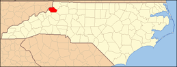 | |
| CDPs | ||
| Unincorporated communities | ||
| Footnotes | ‡This populated place also has portions in an adjacent county or counties | |
