New Bern, North Carolina
| New Bern, North Carolina | |
|---|---|
| City | |
.jpg) | |
 Location of New Bern in Craven County, North Carolina | |
 New Bern Location within the contiguous United States of America | |
| Coordinates: 35°06′30.6″N 77°02′38.8″W / 35.108500°N 77.044111°WCoordinates: 35°06′30.6″N 77°02′38.8″W / 35.108500°N 77.044111°W | |
| Country |
|
| State |
|
| County | Craven |
| Settled | 1710 |
| Incorporated | 23 November 1723 |
| Founded by | The Baron of Bernberg |
| Named for | Bern, Switzerland |
| Government[1] | |
| • Type | Council–Manager |
| • Mayor | Dana Outlaw (I) |
| • Board of Aldermen | |
| • Manager | Mark Stephens |
| Area | |
| • Total | 29.7 sq mi (76.9 km2) |
| • Land | 28.2 sq mi (73.1 km2) |
| • Water | 1.4 sq mi (3.7 km2) |
| Elevation | 30 ft (3 m) |
| Population (2010) | |
| • Total | 29,524 |
| • Estimate (2016)[2] | 30,101 |
| • Density | 990/sq mi (380/km2) |
| Time zone | UTC-5 (Eastern (EST)) |
| • Summer (DST) | UTC-4 (EDT) |
| ZIP codes | 28560, 28562 |
| Area code(s) | 252 |
| FIPS code | 37-46340[3] |
| GNIS feature ID | 1013911[4] |
| Website |
www |
New Bern is a city in Craven County, North Carolina, United States. As of the 2010 census it had a population of 29,524,[5] which had risen to an estimated 30,242 as of 2013.[6] It is the county seat of Craven County and the principal city of the New Bern Metropolitan Statistical Area.
It is located at the confluence of the Neuse and the Trent rivers, near the North Carolina coast. It lies 112 miles (180 km) east of Raleigh, 87 miles (140 km) northeast of Wilmington, and 162 miles (261 km) south of Norfolk. New Bern is the birthplace of Pepsi.
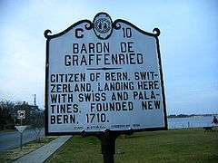
New Bern was settled in 1710 by Bernese and Palatine immigrants under the auspices of Christoph von Graffenried, 1st Baron of Bernberg. The new colonists named their settlement after Bern, Switzerland, home state of their patron.[7] The English connection with Switzerland had been established by some Marian exiles who sought refuge in Protestant parts of Switzerland. There were also marriages between the Royal House of Stuart and notable people in the history of Calvinism. The colonists later discovered they had started their settlement on the site of a former Tuscarora village named Chattoka. This caused conflicts with the Tuscaroras who were in the area.
New Bern is the second-oldest European-American colonial town in North Carolina (after Bath). It served as the capital of the North Carolina colonial government, then briefly as the state capital. After the American Revolution, New Bern became wealthy and quickly developed a rich cultural life. At one time New Bern was called "the Athens of the South,"[8] renowned for its Masonic Temple and Athens Theater. These are both still very active today.
New Bern has four historic districts listed on the National Register of Historic Places; their numerous contributing buildings include residences, stores and churches dating back to the early eighteenth century. Within easy walking distance of the waterfront are more than 164 homes and buildings listed on the National Register. Also nearby are several bed and breakfasts, hotels, restaurants, banks, antiques stores and specialty shops. The historic districts contain many of the city's 2,000 crape myrtles—its official flower—and developed gardens. New Bern has two "Local Historic Districts", a municipal zoning overlay that affords legal protection to the exteriors of New Bern's irreplaceable historic structures. These areas provide much of New Bern's unique charm, appeal to retirees and heritage tourism, and contribute to the city's economic success. The Local Historic Districts, while vitally important to New Bern, comprise only 2.43% of New Bern's 27-square-mile area. There is considerable area available for new development.
History
Varying complex cultures of indigenous peoples had lived along the waterways of North Carolina for thousands of years before Europeans explored the area. The Tuscarora, an Iroquoian-speaking people, had migrated south from the Great Lakes area in some ancient time and occupied this area for hundreds of years before any Europeans arrived. They had an ancient village, Chattoka, here at the confluence of the rivers. They resisted encroachment by the Europeans, rising up in resistance in 1712.
New Bern was settled in 1710 by Bernese and Palatine immigrants under the auspices of Christoph von Graffenried, 1st Baron of Bernberg.[9][10] The new colonists named their settlement after the Canton of Bern, Switzerland, home state of their patron. Graffenried had the original plat of the town laid out in the shape of a cross, though later development and additional streets have obscured this pattern within the regular street grid. This became the first permanent seat of the colonial government of North Carolina.
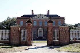
The Governor's Palace, New Bern (also known as Tryon Palace), served as the capitol of North Carolina from 1770 until the state government relocated to Raleigh in 1792 after a fire destroyed much of the capitol.
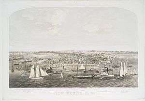
During the 19th-century Federal period, New Bern became the largest city in North Carolina, developed on the trade of goods and slaves associated with plantation agriculture.[11] After Raleigh was named the state capital, New Bern rebuilt its economy by expanding on trade via shipping routes to the Caribbean and New England.[11] It was part of the Triangle Trade in sugar, slaves, and desired goods. It reached a population of 3,600 in 1815.[11]
In 1862 during the early stages of the American Civil War, the area was the site of the Battle of New Bern. Federal forces captured and occupied the town until the end of the war in 1865. Nearly 10,000 enslaved blacks escaped during this period in the region and went to the Union camps for protection and freedom. The Union Army set up the Trent River contraband camp at New Bern to house the refugees. It organized the adults for work. Missionaries came to teach literacy to both adults and children.
After the January 1863 Emancipation Proclamation of President Abraham Lincoln, slaves in Union-occupied territories were declared free; more freedmen came to the Trent River camp for protection. The Army appointed Horace James, a Congregational chaplain from Massachusetts, as the "Superintendent of Negro Affairs for the North Carolina District"[12] on behalf of the Bureau of Refugees, Freedmen and Abandoned Lands. In addition to the Trent River camp, James supervised development of the offshore Roanoke Island Freedmen's Colony, which was intended to be self-supporting.[13] Beginning in 1863, a total of nearly 4,000 freedmen from North Carolina enlisted in the United States Colored Troops to fight with the Union for their permanent freedom, including 150 men from the colony on Roanoke Island.[12]

Due to the continuous occupation by the Union troops, New Bern avoided some of the destruction of the war years. There was much social disruption because of the occupation and the thousands of freedmen camped near the city. Still, it recovered more quickly than many cities after the war.
By the 1870s the lumber industry was developing as the chief part of New Bern's economy. Timber harvested could be sent downriver by the two nearby rivers. The city continued to be a center for freedmen, who created communities independent of white supervision: thriving churches, fraternal associations, and their own businesses. By 1877 the city had a majority-black population.
The state legislature defined the city and county as part of North Carolina's 2nd congressional district which, as former plantation territory, held a concentration of the state's black residents. They elected four blacks to the US Congress in the late 19th century. The state's passage of a constitutional suffrage amendment in 1900 used various devices to disenfranchise black citizens. As a result, they were totally closed out of the political process, including participation on juries and in local offices; white Democrats maintained this suppression mostly, until after passage of federal civil rights legislation, including the Voting Rights Act of 1965, which provided for federal enforcement of constitutional rights.
By 1890 New Bern had become the largest lumber center in North Carolina and one of the largest in all of the South. During this time, as many as 16 lumber mills were running and employing hundreds of men from New Bern and the area. The competitive nature of the lumber barons, the abundance of lumber and craftsmen, led to the construction in New Bern of some of the finest homes in the South, many of which have survived. The lumber boom lasted until the 1920s. One by one the lumber mills went out of business. Today only Weyerhaeuser manufactures lumber in the area.
The city has four National Historic Districts and two local ones, which have helped preserve the character of the architecture. The Downtown Local Historic District is 368.64 acres (149.18 ha) or 0.576 square miles (1.49 km2); the Riverside Local Historic District covers 51.94 acres (21.02 ha) or 0.081 square miles (0.21 km2).
Union Point Park borders the Neuse and Trent rivers. It is the site of the city's major celebrations, such as Neuse River Days and the Fourth of July. Since 1979 the Swiss Bear Downtown Revitalization Corporation has worked to redevelop downtown; it has stimulated the creation of art galleries, specialty shops, antiques stores, restaurants and inns. This area has become a social and cultural hub. James Reed Lane is a downtown mini-park and pedestrian walk-through on Pollock Street across from historic Christ Church. Private restoration efforts have returned many of the downtown buildings to their turn-of-the-twentieth-century elegance.
In 2005, a segment of NBC's The Today Show noted that New Bern was one of the best places in the United States to retire. Retirees from the northern states have added to its population.
On September 14-15, 2018 hurricane Florence made landfall to the south of New Bern and storm surge from the storm of up to 6 feet in addition to days of heavy rains severely flooded various parts of the town. By September 16, many relief organizations, including Samaritans Purse and the Red Cross, were on the ground assisting residents in need. On September 19, President, Donald Trump, toured the area to view the damage firsthand and also aided the volunteer relief by handing out warm cooked meals to local residents.
The Attmore-Oliver House, J.T. Barber School, Baxter Clock, Bellair, Blades House, Bryan House and Office, Cedar Grove Cemetery, Cedar Street Recreation Center, Centenary Methodist Church, Central Elementary School, Christ Episcopal Church and Parish House, Coor-Bishop House, Coor-Gaston House, Craven Terrace, DeGraffenried Park Historic District, Ebenezer Presbyterian Church, First Baptist Church, First Church of Christ, Scientist, First Missionary Baptist Church, First Presbyterian Church and Churchyard, Ghent Historic District, Gull Harbor, Harvey Mansion, Hawks House, William Hollister House, Thomas Jerkins House, Jerkins-Duffy House, Jones-Jarvis House, Ulysses S. Mace House, Masonic Temple and Theater, Mount Shiloh Missionary Baptist Church, New Bern Battlefield Site, New Bern Historic District, New Bern Municipal Building, New Bern National Cemetery, Rhem-Waldrop House, Riverside Historic District, Rue Chapel AME Church, Slover-Bradham House, Eli Smallwood House, Isaac H. Smith, Jr., House, Benjamin Smith House, Smith-Whitford House, St. John's Missionary Baptist Church, St. Paul's Roman Catholic Church, St. Peter's AME Zion Church, Edward R. Stanly House, John Wright Stanly House, Stevenson House, Isaac Taylor House, Tisdale-Jones House, and York-Gordon House are listed on the National Register of Historic Places.[14][15]
Geography
New Bern is located in the center of Craven County at 35°6′33″N 77°4′9″W / 35.10917°N 77.06917°W (35.109070, −77.069111).[16] It is sited at the junction of the Trent and Neuse rivers, two tidal waterways.
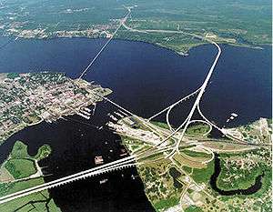
U.S. Route 70 and U.S. Route 17 pass through the city, merging briefly as a four-lane expressway passing south of the city center. US 70 leads west 33 miles (53 km) to Kinston and southeast 35 miles (56 km) to Morehead City near the Atlantic Ocean. Raleigh, the state capital, is 112 miles (180 km) west via US 70. US 17 leads southwest 37 miles (60 km) to Jacksonville, North Carolina, and crosses the Neuse River on a new bridge to lead north 36 miles (58 km) to Washington, North Carolina.
New Bern is located in North Carolina's Inner Banks region. According to the United States Census Bureau, the city has a total area of 29.7 square miles (76.9 km2), of which 28.2 square miles (73.1 km2) is land and 1.4 square miles (3.7 km2), or 4.87%, is water.[5]
Climate
New Bern experiences a humid subtropical climate typical of the Atlantic coastal plain. Summers are hot and humid, with frequent afternoon thunderstorms that account for much of the higher summer precipitation. Spring and fall are generally mild, with fall foliage occurring from late October to early November. Winters are relatively mild and drier than the remainder of the year, with infrequent snowfall.
| Climate data for New Bern, North Carolina | |||||||||||||
|---|---|---|---|---|---|---|---|---|---|---|---|---|---|
| Month | Jan | Feb | Mar | Apr | May | Jun | Jul | Aug | Sep | Oct | Nov | Dec | Year |
| Record high °F (°C) | 81 (27) |
88 (31) |
90 (32) |
95 (35) |
100 (38) |
105 (41) |
106 (41) |
103 (39) |
101 (38) |
97 (36) |
87 (31) |
83 (28) |
106 (41) |
| Average high °F (°C) | 55 (13) |
58 (14) |
65 (18) |
74 (23) |
80 (27) |
87 (31) |
90 (32) |
88 (31) |
83 (28) |
75 (24) |
66 (19) |
58 (14) |
73 (23) |
| Average low °F (°C) | 34 (1) |
36 (2) |
42 (6) |
50 (10) |
59 (15) |
68 (20) |
72 (22) |
70 (21) |
65 (18) |
54 (12) |
44 (7) |
36 (2) |
53 (12) |
| Record low °F (°C) | 1 (−17) |
6 (−14) |
17 (−8) |
29 (−2) |
32 (0) |
44 (7) |
55 (13) |
50 (10) |
43 (6) |
26 (−3) |
17 (−8) |
−4 (−20) |
−4 (−20) |
| Average rainfall inches (mm) | 4.77 (121.2) |
3.80 (96.5) |
4.49 (114) |
3.40 (86.4) |
4.19 (106.4) |
4.80 (121.9) |
6.48 (164.6) |
6.84 (173.7) |
5.45 (138.4) |
3.39 (86.1) |
3.23 (82) |
3.84 (97.5) |
54.68 (1,388.9) |
| Average snowfall inches (cm) | 1.0 (2.5) |
0.8 (2) |
0.5 (1.3) |
0.1 (0.3) |
0 (0) |
0 (0) |
0 (0) |
0 (0) |
0 (0) |
0 (0) |
0.1 (0.3) |
0.2 (0.5) |
2.7 (6.9) |
| Source #1: National Weather Service[17] | |||||||||||||
| Source #2: Weatherbase[18] | |||||||||||||
Transportation
Coastal Carolina Regional Airport is a public airport located 3 miles (5 km) south of the central business district of New Bern. The airport offers connecting flights to the Atlanta and Charlotte airports daily.
Demographics
| Historical population | |||
|---|---|---|---|
| Census | Pop. | %± | |
| 1800 | 2,467 | — | |
| 1820 | 3,663 | — | |
| 1830 | 3,796 | 3.6% | |
| 1840 | 3,690 | −2.8% | |
| 1850 | 4,681 | 26.9% | |
| 1860 | 5,432 | 16.0% | |
| 1870 | 5,849 | 7.7% | |
| 1880 | 6,443 | 10.2% | |
| 1890 | 7,843 | 21.7% | |
| 1900 | 9,090 | 15.9% | |
| 1910 | 9,961 | 9.6% | |
| 1920 | 12,198 | 22.5% | |
| 1930 | 11,981 | −1.8% | |
| 1940 | 11,815 | −1.4% | |
| 1950 | 15,812 | 33.8% | |
| 1960 | 15,717 | −0.6% | |
| 1970 | 14,660 | −6.7% | |
| 1980 | 14,557 | −0.7% | |
| 1990 | 17,363 | 19.3% | |
| 2000 | 23,128 | 33.2% | |
| 2010 | 29,524 | 27.7% | |
| Est. 2016 | 30,101 | [2] | 2.0% |
| U.S. Decennial Census[19] | |||
The population of the area was 30,291 (95% urban, 5% rural) people in 2014, a 31% increase in growth since 2000. Gender distribution is 47.5% male and 52.5% female with a median resident age of 38.8. The percentage of residents under the age of 18 was 24.2%. The 2012 racial breakdown includes White alone – 16,304 (54%), Black alone – 9,634 (31.9%), Asian alone – 1,844 (6.1%), Hispanic – 1,626 (5.4%), Two or more races – 747 (2.5%), American Indian alone – 50 (0.2%) and Other race alone – 13 (0.04%). The median income for a household in the city in 2015 was $41,285.[20]
The City of New Bern 2010 Census information shows the population of the area was approximately 29,524 people. From 2000 to 2010, the New Bern city population growth percentage was 27.7% (or from 23,128 people to 29,524 people). 22.8% of the New Bern city residents were under 18 years of age. Census 2010 race data for New Bern city include the racial breakdown percentages of 57.0 white, 32.8% black, 3.6% Asian, 5.8% Hispanic and less than 1% Native American, Also, there were 14,471 housing units in the City of New Bern, 88.2% of which were occupied housing units.
Education
Colleges
High schools
- New Bern High School
- Craven Early College High School
- West Craven High School
- Epiphany School
- Early College EAST High School
Middle schools
- Grover C. Fields Middle School
- H.J. McDonald Middle School
- West Craven Middle School
Elementary schools
- Trent Park Elementary School
- Oaks Road Elementary School
- J.T. Barber Elementary School
- Brinson Memorial Elementary School
- Ben D. Quinn Elementary School
- Albert H. Bangert Elementary School
- Creekside Elementary School
- Bridgeton Elementary School
Private schools
- Calvary Baptist Christian School
- St. Paul Catholic School (St. Paul Education Center)
- The Epiphany School of Global Studies
- New Bern Christian Academy
Radio stations
- 1450 AM / 104.3 FM WNOS – News/Talk/Sports
- 1490 AM / 103.9 FM WWNB - ESPN Radio – sports talk
- 88.5 FM WZNB - Public Radio East – Classical Music
- 89.3 FM WTEB - Public Radio East – NPR/News/Talk
- 89.9 FM W210BS - Classical WCPE
- 92.7 FM WBNK - K-Love - Christian Contemporary
- 91.9 FM WAAE - American Family Radio – Religious
- 93.3 FM WERO - Bob 93.3 - Top 40
- 94.1 FM WNBU - Talk
- 95.1 FM WRNS - Country
- 95.7 FM W239BC - R&B Oldies
- 97.9 FM WNBB – Classic Country
- 98.3 FM WLGT - The Bridge – Contemporary Christian
- 99.5 FM WXNR – Hot FM – Top 40
- 99.9 FM WTTY-LP - Oldies
- 101.9 FM WIKS - Kiss FM – Hip Hop & R&B
- 103.3 FM WMGV - V103.3 - Soft AC
- 104.5 FM WSTK - Variety
- 105.1 FM WHAR - Air 1 - Christian Contemporary
- 105.5 FM WXQR – Pure Rock
- 107.9 FM WNCT – Classic Hits
- 106.5 FM WSFL – Classic Rock
- 107.1 FM WTKF-FM – The Talk Station
In popular culture
- Jules Verne's 1896 novel Face au Drapeau (Facing the Flag) featured New Bern as the place where one of that story's main characters is committed to an asylum by the U.S. government.[21]
- Nicholas Sparks set his novels, The Notebook and A Bend in the Road, in the city.
Notable people
- Lewis Addison Armistead, Confederate Army brigadier general[22]
- Shawn Armstrong, MLB pitcher with the Cleveland Indians
- George Edmund Badger, US Senator (1846–1855)
- Graham Arthur Barden, 13-term US congressman (1935–1961)
- Cullen A. Battle, postbellum mayor of New Bern
- Samuel J. Battle, first African-American policeman in New York City
- Walt Bellamy, NBA Hall of Fame basketball player
- Caleb Bradham, inventor of Pepsi-Cola
- John Heritage Bryan, US congressman (1825–1829)
- Chase Crawford, actor and producer
- Gary Downs, NFL player for the New York Giants, Atlanta Falcons, Denver Broncos; assistant coach East Tennessee State
- Davon Drew, tight end for NFL's Baltimore Ravens
- Elwood Edwards, voice of AOL's "You've got mail"
- William Gaston, jurist and US congressman (1813–1817)
- Christoph von Graffenried, 1st Baron of Bernberg (1661–1743), British peer from Canton of Bern, who founded New Bern in 1710[7]
- Montario Hardesty, NFL running back for Cleveland Browns
- William J. Hutchins (1813–1884), mercantilist, railroad owner, and Mayor of Houston (1861)[23]
- Donna Hutchinson, former member of Arkansas House of Representatives, born in New Bern in 1949[24]
- George Koonce, NFL player for Green Bay Packers and Seattle Seahawks, Athletic Director of University of Wisconsin–Milwaukee
- Valentina Lisitsa, concert pianist
- Bob Mann, NFL player, first African American to play for Detroit Lions, later also Green Bay Packers
- Aaron Martin, former NFL player for Los Angeles Rams, Philadelphia Eagles, and Washington Redskins.
- Eliza Jane McKissack, director and founding member of Conservatory of Music at University of North Texas
- Linda McMahon, 25th administrator of the Small Business Administration and former CEO OF World Wrestling Entertainment
- Michael R. Morgan, African American justice of the Supreme Court of North Carolina
- Dan Neil, Pulitzer Prize-winning automotive journalist
- James E.C. Perry, justice of Supreme Court of Florida
- Teddy Shapou, Flying Tiger during World War II
- Brian Simmons, NFL player for Cincinnati Bengals and New Orleans Saints
- William Henry Singleton, former slave who became noted Civil War soldier
- Furnifold Simmons, U.S. senator
- Richard Dobbs Spaight, signer of Declaration of Independence
- Edward Stanly, son of John Stanly, congressman 1837–1843, appointed military governor of North Carolina in 1862
- Fabius Maximus Stanly (1815–1882), rear admiral of U.S. Navy, namesake of WWII destroyer, USS Stanly, DD-478
- John Stanly, father of Edward Stanly, congressman (1801–1803, 1809–1811)
- Adam Warren, MLB player for New York Yankees and Chicago Cubs
- George Henry White, attorney, banker, last of four African-American congressmen from North Carolina in the 19th century; next was not elected until 1992
- Kevin Meade Williamson, screenwriter, I Know What You Did Last Summer, television series Dawson's Creek
- Bayard Wootten (1875–1959), photographer and suffragette
References
- ↑ "Which Ward Do I Live in?". City of New Bern. Retrieved February 9, 2018.
- 1 2 "Population and Housing Unit Estimates". Retrieved June 9, 2017.
- ↑ "American FactFinder". United States Census Bureau. Retrieved January 31, 2008.
- ↑ "US Board on Geographic Names". United States Geological Survey. October 25, 2007. Retrieved January 31, 2008.
- 1 2 "Geographic Identifiers: 2010 Demographic Profile Data (G001): New Bern city, North Carolina". U.S. Census Bureau, American Factfinder. Retrieved January 2, 2015.
- ↑ "Annual Estimates of the Resident Population: April 1, 2010 to July 1, 2013 (PEPANNRES): North Carolina Incorporated Places". U.S. Census Bureau, American Factfinder. Retrieved January 2, 2015.
- 1 2 Colonial Records of North Carolina. n.d. pp. 985–986. LCCN 01006807. OCLC 2864657 – via Internet Archive.
- ↑ http://www.newbern-nc.org/visitor/city-history/
- ↑ Bishir, Catherine (2005). North Carolina Architecture. UNC Press. p. 2.
- ↑ "Wilhelmsburg, Colonial Williamsburg, Robert A. Selig, The Potomac Appalachian Trail Club History". Patc.us. Retrieved August 16, 2009.
- 1 2 3 Bishir, Catherine (2005). North Carolina Architecture. UNC Press. p. 84.
- 1 2 "The Roanoke Island Freedmen's Colony", provided by National Park Service, at North Carolina Digital History: LEARN NC, accessed November 11, 2010
- ↑ Click, Patricia C. "The Roanoke Island Freedmen's Colony", Roanoke Island Freedmen's Colony website, 2001, accessed November 9, 2010
- ↑ National Park Service (2010-07-09). "National Register Information System". National Register of Historic Places. National Park Service.
- ↑ "National Register of Historic Places Listings". Weekly List of Actions Taken on Properties: 8/18/14 through 8/23/14. National Park Service. 2014-08-29.
- ↑ "US Gazetteer files: 2010, 2000, and 1990". United States Census Bureau. February 12, 2011. Retrieved April 23, 2011.
- ↑ "New Bern NC". National Weather Service. Retrieved March 25, 2010.
- ↑ "Weather Channel: Historical Weather for New Bern, NC". Weatherbase. Retrieved January 22, 2010.
- ↑ "Census of Population and Housing". Census.gov. Retrieved June 4, 2015.
- ↑ http://www.city-data.com/city/New-Bern-North-Carolina.html#ixzz3HkVOfRmM
- ↑ Backwards to Britain, edited by William Butcher (Chambers, 1992)
- ↑ Who Was Who in America, Historical Volume, 1607–1896. Marquis Who's Who. 1963.
- ↑ Julia Beazley (April 6, 2017). "HUTCHINS, WILLIAM J." Handbook of Texas Online. Texas State Historical Association. Retrieved November 17, 2017.
- ↑ "Donna Hutchinson". ballotpedia.org. Retrieved August 17, 2013.
Further reading
- Browning, Judkin. Shifting Loyalties: The Union Occupation of Eastern North Carolina (Univ of North Carolina Press, 2011). focus on Craven County
- Farmer, Vina Hutchinson. New Bern (Arcadia Publishing, 2007).
- Kinsey, Marissa N. "Beyond the Vale: Visualizing Slavery in Craven County, North Carolina." (2017). online
- Todd, Vincent H., ed. (1920). Christoph von Graffenried's Account of the Founding of New Bern. Publications of the North Carolina Historical Commission. Raleigh: Edwards & Broughton Printing Co. LCCN 21027196. OCLC 1107613. OL 6640211M – via Internet Archive.
- Watson, Alan D. A History of New Bern and Craven County (Tryon Palace Commission, 1987).
External links
- Government
- General information

- New Bern Convention and Visitors Bureau
- New Bern-Craven County Public Library
- New Bern Sun Journal, daily newspaper
- Works by or about New Bern, North Carolina at Internet Archive
- Works by or about New Bern, North Carolina in libraries (WorldCat catalog)

- "Newbern". Collier's New Encyclopedia. 1921.
- "Newbern". Encyclopædia Britannica (11th ed.). 1911.
- "Newbern". New International Encyclopedia. 1905.
- "Newbern, N. C.". The New Student's Reference Work. 1914.
- "New Berne". The American Cyclopædia. 1879.
Municipalities and communities of Craven County, North Carolina, United States | ||
|---|---|---|
| Cities | 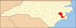 | |
| Towns | ||
| CDPs | ||
| Unincorporated communities | ||
| Military base | ||