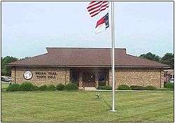
Indian Trail, North Carolina
| Indian Trail, North Carolina | ||
|---|---|---|
| Suburban Town | ||
 | ||
| ||
| Motto(s): "Crossing Paths" | ||
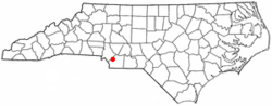 Location in the state of North Carolina | ||
| Coordinates: 35°4′37″N 80°40′9″W / 35.07694°N 80.66917°WCoordinates: 35°4′37″N 80°40′9″W / 35.07694°N 80.66917°W | ||
| Country |
| |
| State | North Carolina | |
| County | Union | |
| Area | ||
| • Total | 22.1 sq mi (57.2 km2) | |
| • Land | 22.1 sq mi (57.2 km2) | |
| • Water | 0.0 sq mi (0.1 km2) | |
| Elevation | 715 ft (218 m) | |
| Population (2010) | ||
| • Total | 33,518 | |
| • Estimate (2017)[1] | 38,980 | |
| • Density | 1,500/sq mi (590/km2) | |
| Time zone | UTC−5 (EST) | |
| • Summer (DST) | UTC−4 (EDT) | |
| ZIP code | 28079 | |
| Area code(s) | 704 | |
| FIPS code | 37-33560[2] | |
| GNIS feature ID | 0987370[3] | |
| Website | http://www.indiantrail.org/ | |
Indian Trail is a suburban town in Union County, North Carolina, United States. Founded on March 12, 1861, the town holds a history of traders traveling along the "Indian Trail," which ran from Petersburg, Virginia, to the Waxhaw Indians, and gold mining. Indian Trail was first a farming community; however, German and Scot-Irish settlers began to move into the area due to its geographical location. In 1874, the Seaboard Coast Line Railroad was built between the cities Charlotte, North Carolina and Monroe, North Carolina. The railroad, which runs through the town, brought prosperity to the area. Indian Trail was incorporated as a town in 1907, with established city limits based upon a one-half mile radius from the intersection of Indian Trail Road and the Seaboard Railroad. Indian Trail has grown rapidly in the 21st Century: a 2011 CNN article stated that Indian Trail's census count jumped from 1,942 in 1990 to 33,518 in 2010.[4] Every Fourth of July the town holds an annual parade which is one of the biggest parades in the Charlotte metropolitan area.
Geography
Indian Trail is located at 35°4′37″N 80°40′9″W / 35.07694°N 80.66917°W (35.076944, -80.669167).[5]
Located in the southern portion of the Piedmont region of North Carolina, Indian Trail is a rapidly growing suburb approximately 10 miles southeast of Charlotte in Union County. Indian Trail is located in the northwestern portion of Union County, which is among the 10 fastest-growing counties in the United States. It is bordered by seven other municipalities, in addition to unincorporated portions of Union County. Its proximity to Charlotte and the regional transportation network it enjoys should continue to generate growth and development within its boundaries.
According to the United States Census Bureau, the town has a total area of 22.1 square miles (57 km2), of which, 22.1 square miles (57 km2) of it is land and 0.04 square miles (0.10 km2) of it (0.26%) is water.
Demographics
| Historical population | |||
|---|---|---|---|
| Census | Pop. | %± | |
| 1910 | 154 | — | |
| 1920 | 224 | 45.5% | |
| 1930 | 209 | −6.7% | |
| 1940 | 225 | 7.7% | |
| 1950 | 308 | 36.9% | |
| 1960 | 364 | 18.2% | |
| 1970 | 405 | 11.3% | |
| 1980 | 811 | 100.2% | |
| 1990 | 1,942 | 139.5% | |
| 2000 | 11,905 | 513.0% | |
| 2010 | 33,518 | 181.5% | |
| Est. 2017 | 38,980 | [1] | 16.3% |
| U.S. Decennial Census[6] | |||
As of the census[7] of 2010, there were 33,518 people, 11,121 households, and 9,060 families residing in the town. The population density was 1,545.4 people per square mile. The racial makeup of the town was 81.00% White, 10.0% African American, 0.5% Native American, 1.8% Asian, 0.0% Pacific Islander, 4.4% from other races, and 2.3% from two or more races. Hispanic or Latino of any race were 10.9% of the population.
There were 11,121 households out of which 48.7% had children under the age of 18 living with them, 66.1% were married couples living together, 10.9% had a female householder with no husband present, and 18.5% were non-families. 18.5% of all households were made up of individuals and 4.1% had someone living alone who was 65 years of age or older. The average household size was 3.01 and the average family size was 3.35.
In the town, the population was spread out with 18.9% under 10 years, 15.9% from 10 to 19, 9.6% from 20 to 29, 17.7% from 30 to 39, 17.3% from 40 to 49, 9.9% from 50 to 59, 6.6% from 60 to 69, 2.9% from 70 to 79, and 1.1% who were 80 years of age or older. The median age was 33.7 years. Females make up 50.9% of the population.
The median income for a household in the town was $66,333. The per capita income for the town was $26,096. About 6.3% of the population is below the poverty line.
Notable industries
References
- 1 2 "Annual Estimates of the Resident Population: April 1, 2010 to July 1, 2017". Retrieved September 6, 2018.
- ↑ "American FactFinder". United States Census Bureau. Archived from the original on September 11, 2013. Retrieved 2008-01-31.
- ↑ "US Board on Geographic Names". United States Geological Survey. 2007-10-25. Retrieved 2008-01-31.
- ↑ CNN, By Jamie Gumbrecht,. "Making a home in one of North Carolina's fastest-growing places". cnn.com. Retrieved 10 April 2018.
- ↑ "US Gazetteer files: 2010, 2000, and 1990". United States Census Bureau. 2011-02-12. Retrieved 2011-04-23.
- ↑ "Census of Population and Housing". Census.gov. Archived from the original on May 12, 2015. Retrieved June 4, 2015.
- ↑ "Archived copy". Archived from the original on 2015-07-08. Retrieved 2015-07-07.
External links
- Official website of Indian Trail, NC
- CNN Article about Indian Trail: "Making a home in one of North Carolina's fastest-growing places" by Jamie Gumbrecht (June 9, 2011)
|  | ||||||||||||
|
| |||||||||||||
Municipalities and communities of Union County, North Carolina, United States | ||
|---|---|---|
| City | 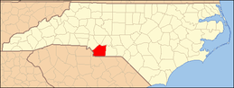 | |
| Towns | ||
| Villages | ||
| CDP | ||
| Unincorporated communities | ||
| Ghost town | ||
| Footnotes | ‡This populated place also has portions in an adjacent county or counties | |
