Pamlico County, North Carolina
| Pamlico County, North Carolina | ||
|---|---|---|
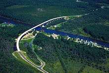 A section of the Intracoastal Waterway in Pamlico County crossed by the Hobucken Bridge. | ||
| ||
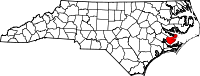 Location in the U.S. state of North Carolina | ||
 North Carolina's location in the U.S. | ||
| Founded | 1872 | |
| Named for | Pamlico Indians | |
| Seat | Bayboro | |
| Largest town | Bayboro | |
| Area | ||
| • Total | 567 sq mi (1,469 km2) | |
| • Land | 337 sq mi (873 km2) | |
| • Water | 230 sq mi (596 km2), 41% | |
| Population | ||
| • (2010) | 13,143 | |
| • Density | 39/sq mi (15/km2) | |
| Congressional district | 3rd | |
| Time zone | Eastern: UTC−5/−4 | |
| Website |
www | |

Pamlico /ˈpæmlɪkoʊ/ [1] County is a county located in the U.S. state of North Carolina. As of the 2010 Census, the population was 13,144.[2] Its county seat is Bayboro.[3]
Pamlico County is part of the New Bern, NC Micropolitan Statistical Area.
History
The county was formed in 1872 from parts of Beaufort and Craven counties. It was named for Pamlico Sound, which adjoins it. Vernacular usage in the area, especially in Craven County, refers to Pamlico County as being "down in the county." Prior to 1872, it was a part of Craven County and has a very low elevation. Most of the county, according to FRIS, North Carolina Flood Risk Information System, much of the county is subject to flooding in storm surges. After it was separated from Craven, the old nickname survives. Pamlico County remains rural in character and flavor, although the last decade has brought a good deal of residential development, largely the result of northern retirees and investors attracted to the many miles of waterfront property.
The county is anchored on the east by the Town of Oriental, a popular waystation for boaters traveling the Intracoastal Waterway, and by unincorporated Lowland. New Bern across the county line in Craven County to the west, is the primary trade area for Pamlico County. The unincorporated community of Olympia is in the western county.
Law and government
Pamlico County is governed by an elected, seven-member Board of Commissioners. The county is a member of the regional Eastern Carolina Council of Governments.
| Year | Republican | Democratic | Third parties |
|---|---|---|---|
| 2016 | 62.0% 4,258 | 35.6% 2,448 | 2.4% 164 |
| 2012 | 59.9% 4,051 | 39.2% 2,647 | 1.0% 64 |
| 2008 | 57.0% 3,823 | 42.3% 2,838 | 0.8% 51 |
| 2004 | 60.9% 3,679 | 38.7% 2,335 | 0.4% 24 |
| 2000 | 57.2% 2,999 | 41.7% 2,188 | 1.1% 55 |
| 1996 | 47.4% 2,270 | 46.0% 2,204 | 6.6% 316 |
| 1992 | 38.8% 1,929 | 44.8% 2,229 | 16.4% 817 |
| 1988 | 51.0% 2,297 | 48.6% 2,188 | 0.5% 21 |
| 1984 | 54.1% 2,554 | 45.6% 2,152 | 0.2% 11 |
| 1980 | 39.6% 1,504 | 58.5% 2,224 | 2.0% 75 |
| 1976 | 33.3% 1,068 | 65.9% 2,113 | 0.9% 28 |
| 1972 | 66.1% 1,847 | 32.9% 919 | 1.0% 28 |
| 1968 | 21.5% 745 | 36.9% 1,280 | 41.7% 1,447 |
| 1964 | 35.7% 1,036 | 64.3% 1,864 | |
| 1960 | 38.5% 1,061 | 61.5% 1,697 | |
| 1956 | 40.9% 954 | 59.1% 1,376 | |
| 1952 | 38.7% 903 | 61.3% 1,428 | |
| 1948 | 31.2% 685 | 62.4% 1,370 | 6.5% 142 |
| 1944 | 35.7% 719 | 64.3% 1,295 | |
| 1940 | 33.5% 730 | 66.5% 1,448 | |
| 1936 | 34.6% 860 | 65.4% 1,627 | |
| 1932 | 29.4% 665 | 67.3% 1,526 | 3.3% 75 |
| 1928 | 55.6% 1,099 | 44.4% 878 | |
| 1924 | 36.5% 459 | 63.5% 798 | |
| 1920 | 43.9% 1,008 | 56.1% 1,286 | |
| 1916 | 42.0% 527 | 56.6% 710 | 1.4% 18 |
| 1912 | 6.6% 74 | 62.1% 694 | 31.2% 349 |
Geography
According to the U.S. Census Bureau, the county has a total area of 567 square miles (1,470 km2), of which 337 square miles (870 km2) is land and 230 square miles (600 km2) (41%) is water.[5]
Adjacent counties
- Beaufort County - north
- Hyde County - northeast
- Carteret County - southeast
- Craven County - southwest
Major highways
Demographics
| Historical population | |||
|---|---|---|---|
| Census | Pop. | %± | |
| 1880 | 6,323 | — | |
| 1890 | 7,146 | 13.0% | |
| 1900 | 8,045 | 12.6% | |
| 1910 | 9,966 | 23.9% | |
| 1920 | 9,060 | −9.1% | |
| 1930 | 9,299 | 2.6% | |
| 1940 | 9,706 | 4.4% | |
| 1950 | 9,993 | 3.0% | |
| 1960 | 9,850 | −1.4% | |
| 1970 | 9,467 | −3.9% | |
| 1980 | 10,398 | 9.8% | |
| 1990 | 11,372 | 9.4% | |
| 2000 | 12,934 | 13.7% | |
| 2010 | 13,144 | 1.6% | |
| Est. 2016 | 12,821 | [6] | −2.5% |
| U.S. Decennial Census[7] 1790-1960[8] 1900-1990[9] 1990-2000[10] 2010-2013[2] | |||
Census reports show a marked drop of nearly 10 percent in county population from 1910 to 1920, the period of the Great Migration of African Americans from rural areas of the South to northern and midwestern industrial cities offering more economic and social opportunities. Workers were recruited by northern industries, including the Pennsylvania Railroad, which was rapidly expanding at the time.
As of the census[11] of 2000, there were 12,934 people, 5,178 households, and 3,717 families residing in the county. The population density was 38 people per square mile (15/km²). There were 6,781 housing units at an average density of 20 per square mile (8/km²). The racial makeup of the county was 73.17% White, 24.57% Black or African American, 0.53% Native American, 0.38% Asian, 0.02% Pacific Islander, 0.59% from other races, and 0.74% from two or more races. 1.32% of the population were Hispanic or Latino of any race.
There were 5,178 households out of which 25.20% had children under the age of 18 living with them, 56.60% were married couples living together, 11.50% had a female householder with no husband present, and 28.20% were non-families. 25.00% of all households were made up of individuals and 12.10% had someone living alone who was 65 years of age or older. The average household size was 2.38 and the average family size was 2.81.
In the county, the population was spread out with 21.10% under the age of 18, 6.40% from 18 to 24, 25.80% from 25 to 44, 28.00% from 45 to 64, and 18.80% who were 65 years of age or older. The median age was 43 years. For every 100 females there were 101.40 males. For every 100 females age 18 and over, there were 99.80 males.
The median income for a household in the county was $34,084, and the median income for a family was $41,659. Males had a median income of $31,806 versus $21,344 for females. The per capita income for the county was $18,005. About 11.80% of families and 15.30% of the population were below the poverty line, including 24.20% of those under age 18 and 13.40% of those age 65 or over.
Communities
Towns
- Alliance
- Arapahoe
- Bayboro (county seat)
- Grantsboro
- Mesic
- Minnesott Beach
- Oriental
- Stonewall
- Vandemere
Census-designated place
Unincorporated communities
- Florence
- Janerio
- Lowland
- Maribel
- Merritt
- Olympia
- Reelsboro
- Whortonsville
See also
References
- ↑ Talk Like A Tarheel, from the North Carolina Collection's website at the University of North Carolina at Chapel Hill. Retrieved 2013-02-05.
- 1 2 "State & County QuickFacts". United States Census Bureau. Archived from the original on July 16, 2011. Retrieved October 29, 2013.
- ↑ "Find a County". National Association of Counties. Retrieved 2011-06-07.
- ↑ Leip, David. "Dave Leip's Atlas of U.S. Presidential Elections". uselectionatlas.org. Retrieved 2018-03-17.
- ↑ "2010 Census Gazetteer Files". United States Census Bureau. August 22, 2012. Archived from the original on January 12, 2015. Retrieved January 18, 2015.
- ↑ "Population and Housing Unit Estimates". Retrieved June 9, 2017.
- ↑ "U.S. Decennial Census". United States Census Bureau. Retrieved January 18, 2015.
- ↑ "Historical Census Browser". University of Virginia Library. Retrieved January 18, 2015.
- ↑ Forstall, Richard L., ed. (March 27, 1995). "Population of Counties by Decennial Census: 1900 to 1990". United States Census Bureau. Retrieved January 18, 2015.
- ↑ "Census 2000 PHC-T-4. Ranking Tables for Counties: 1990 and 2000" (PDF). United States Census Bureau. April 2, 2001. Retrieved January 18, 2015.
- ↑ "American FactFinder". United States Census Bureau. Retrieved 2008-01-31.
External links
- Pamlico County government official website
- Pamlico County Chamber of Commerce

- NCGenWeb Pamlico County - free genealogy resources for the county
- The Pamlico News - The Weekly Newspaper for Pamlico County
- The County Compass - Weekly newspaper serving Pamlico County, NC
- TownDock.net - News - Views - Web Cams - Weather from Oriental, NC
- Official Website of the Town of Oriental
Places adjacent to Pamlico County, North Carolina | ||||||||||
|---|---|---|---|---|---|---|---|---|---|---|
| ||||||||||
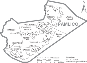
Municipalities and communities of Pamlico County, North Carolina, United States | ||
|---|---|---|
| Towns | 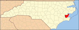 | |
| CDP | ||
| Unincorporated community | ||
