Hertford County, North Carolina
| Hertford County, North Carolina | |
|---|---|
.jpg) Postcard. Chowan College Administration Building, Murfreesboro, North Carolina. | |
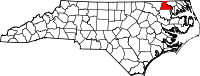 Location in the U.S. state of North Carolina | |
 North Carolina's location in the U.S. | |
| Founded | 1759 |
| Named for | Francis Seymour-Conway, 1st Marquess of Hertford |
| Seat | Winton |
| Largest town | Ahoskie |
| Area | |
| • Total | 360 sq mi (932 km2) |
| • Land | 353 sq mi (914 km2) |
| • Water | 7.3 sq mi (19 km2), 2.0% |
| Population | |
| • (2010) | 24,669 |
| • Density | 70/sq mi (30/km2) |
| Congressional district | 1st |
| Time zone | Eastern: UTC−5/−4 |
| Website |
www |
Hertford County is a county located in the U.S. state of North Carolina. As of the 2010 census, the population was 24,669.[1] Its county seat is Winton.[2] It is classified within the region known in the 21st century as the Inner Banks.
History
Hertford County is home of the Meherrin Indian Tribe, descendants of indigenous people who had inhabited the region for many centuries. After decades of encroachment by English colonists, the Tribe moved south from Virginia, where they settled in 1706 on a reservation abandoned by the Chowanoke. This six-square-mile reservation was at Parker's Ferry near the mouth of the Meherrin River. It was confirmed by a treaty of 1726.[3] However, they were not able to keep the reservation lands.
The Tribe today has approximately 900 enrolled members, most living within 10–15 miles of the former reservation.[3] The tribe is recognized by the state and is seeking Federal recognition. The Meherrin have an annual Pow Wow at the end of October.
The county was formed in 1759 from parts of Bertie County, Chowan County, and Northampton County. It was named for Francis Seymour-Conway, 1st Earl of Hertford, later 1st Marquess of Hertford.[4]
In 1779 the northeastern part of Hertford County was combined with parts of Chowan County and Perquimans County to form Gates County.
Geography
According to the U.S. Census Bureau, the county has a total area of 360 square miles (930 km2), of which 353 square miles (910 km2) is land and 7.3 square miles (19 km2) (2.0%) is water.[5]
Adjacent counties
- Southampton County, Virginia – north
- Gates County – east
- Chowan County – southeast
- Bertie County – south
- Northampton County – west
Major highways
Demographics
| Historical population | |||
|---|---|---|---|
| Census | Pop. | %± | |
| 1790 | 5,949 | — | |
| 1800 | 6,701 | 12.6% | |
| 1810 | 6,052 | −9.7% | |
| 1820 | 7,712 | 27.4% | |
| 1830 | 8,537 | 10.7% | |
| 1840 | 7,484 | −12.3% | |
| 1850 | 8,142 | 8.8% | |
| 1860 | 9,504 | 16.7% | |
| 1870 | 9,273 | −2.4% | |
| 1880 | 11,843 | 27.7% | |
| 1890 | 13,851 | 17.0% | |
| 1900 | 14,294 | 3.2% | |
| 1910 | 15,436 | 8.0% | |
| 1920 | 16,294 | 5.6% | |
| 1930 | 17,542 | 7.7% | |
| 1940 | 19,352 | 10.3% | |
| 1950 | 21,453 | 10.9% | |
| 1960 | 22,718 | 5.9% | |
| 1970 | 23,529 | 3.6% | |
| 1980 | 23,368 | −0.7% | |
| 1990 | 22,523 | −3.6% | |
| 2000 | 22,601 | 0.3% | |
| 2010 | 24,669 | 9.2% | |
| Est. 2016 | 24,136 | [6] | −2.2% |
| U.S. Decennial Census[7] 1790-1960[8] 1900-1990[9] 1990-2000[10] 2010-2013[1] | |||
As of the census[11] of 2010, there were 24,669 people, 8,953 households, and 6,240 families residing in the county. The population density was 64 people per square mile (25/km²). There were 9,724 housing units at an average density of 28 per square mile (11/km²). The racial makeup of the county was 60.5% Black or African American, 35.6% White, 1.1% Native American, 0.5% Asian, 0.0% Pacific Islander, 0.8% from other races, and 1.0% from two or more races. 1.4% of the population were Hispanic or Latino of any race.
There were 8,953 households out of which 30.00% had children under the age of 18 living with them, 45.80% were married couples living together, 19.50% had a female householder with no husband present, and 30.30% were non-families. 26.90% of all households were made up of individuals and 12.10% had someone living alone who was 65 years of age or older. The average household size was 2.48 and the average family size was 2.99.
In the county, the population was spread out with 25.30% under the age of 18, 7.80% from 18 to 24, 26.30% from 25 to 44, 24.80% from 45 to 64, and 15.80% who were 65 years of age or older. The median age was 39 years. For every 100 females there were 85.00 males. For every 100 females age 18 and over, there were 79.50 males.
The median income for a household in the county was $26,422, and the median income for a family was $32,002. Males had a median income of $26,730 versus $20,144 for females. The per capita income for the county was $15,641. About 15.90% of families and 18.30% of the population were below the poverty line, including 21.30% of those under age 18 and 21.00% of those age 65 or over.
Law and government
Hertford County is a member of the Mid-East Commission regional council of governments.
Rivers Correctional Institution, a private prison operated by the GEO Group which operates under contract from the Federal Bureau of Prisons and houses many felons who committed crimes in Washington, DC, is 1 mile (1.6 km) from Winton.[12]
Politics
| Year | Republican | Democratic | Third parties |
|---|---|---|---|
| 2016 | 30.4% 3,099 | 67.8% 6,910 | 1.7% 177 |
| 2012 | 27.5% 3,007 | 71.8% 7,843 | 0.6% 68 |
| 2008 | 29.0% 3,089 | 70.5% 7,513 | 0.5% 48 |
| 2004 | 36.2% 2,942 | 63.2% 5,141 | 0.6% 49 |
| 2000 | 30.2% 2,382 | 69.4% 5,484 | 0.4% 31 |
| 1996 | 25.9% 1,823 | 68.9% 4,856 | 5.3% 370 |
| 1992 | 28.8% 2,208 | 60.1% 4,609 | 11.2% 855 |
| 1988 | 37.5% 2,977 | 62.3% 4,943 | 0.1% 10 |
| 1984 | 41.3% 3,176 | 58.5% 4,498 | 0.3% 21 |
| 1980 | 30.6% 1,854 | 67.7% 4,102 | 1.7% 104 |
| 1976 | 27.5% 1,517 | 72.3% 3,986 | 0.1% 7 |
| 1972 | 58.3% 2,794 | 40.3% 1,928 | 1.4% 67 |
| 1968 | 17.0% 1,125 | 49.6% 3,275 | 33.4% 2,203 |
| 1964 | 20.1% 994 | 79.9% 3,953 | |
| 1960 | 20.1% 781 | 79.9% 3,105 | |
| 1956 | 21.2% 729 | 78.8% 2,708 | |
| 1952 | 16.8% 579 | 83.2% 2,859 | |
| 1948 | 8.0% 196 | 88.8% 2,165 | 3.2% 77 |
| 1944 | 5.9% 125 | 94.1% 1,996 | |
| 1940 | 3.6% 92 | 96.4% 2,464 | |
| 1936 | 3.5% 84 | 96.5% 2,327 | |
| 1932 | 4.6% 88 | 95.1% 1,835 | 0.4% 7 |
| 1928 | 27.6% 393 | 72.4% 1,030 | |
| 1924 | 14.9% 164 | 84.8% 932 | 0.3% 3 |
| 1920 | 16.7% 221 | 83.3% 1,104 | |
| 1916 | 17.6% 209 | 82.3% 977 | 0.1% 1 |
| 1912 | 6.7% 61 | 81.7% 742 | 11.6% 105 |
Economy
Several large employers are located in Hertford County, including a privately run federal prison, Chowan University, a Nucor steel mill, several Perdue poultry processing facilities, an aluminum extrusion facility in Winton, and a lumber-processing facility in Ahoskie. These industries, combined with a typical range of local retail, restaurant and service businesses, combine to give Hertford County one of the lowest unemployment rates in Northeastern North Carolina. The larger area has historically lagged behind the rest of the state in terms of economic development.
Education
Hertford County Public Schools has seven schools ranging from pre-kindergarten to twelfth grade. These include three high schools (the main high school being Hertford County High School), one middle school, and three elementary schools.[14]
Media
Hertford County is served by the Roanoke-Chowan News-Herald newspaper. There are five radio stations in Hertford County. WDLZ FM 98.3, an Adult Contemporary radio station and WWDR AM 1080, an Adult Urban Contemporary radio station are located in Murfreesboro. WQDK FM 99.3, a Country Music radio station and WRCS AM 970, an Urban Gosspel radio station are located in Ahoskie. Also, WBKU FM 91.7, a non-commercial, Contemporary Christian Music radio station, which also broadcasts programming from the American Family Radio network is located in Ahokie.
Communities
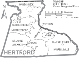
Towns
- Ahoskie
- Como
- Harrellsville
- Murfreesboro
- Winton (county seat)
Census-designated place
Townships
- Ahoskie
- Como
- Harrellsville
- Murfreesboro
- St. John's
- Winton
See also
References
- 1 2 "State & County QuickFacts". United States Census Bureau. Archived from the original on July 11, 2011. Retrieved October 21, 2013.
- ↑ "Find a County". National Association of Counties. Archived from the original on 2011-05-31. Retrieved 2011-06-07.
- 1 2 Brenda Linton and Leslie S. Stewart, Economic Development Assessment for the Meherrin Tribe, University of North Carolina, Jul 2003, accessed 26 Oct 2009
- ↑ Gannett, Henry (1905). The Origin of Certain Place Names in the United States. Govt. Print. Off. p. 155.
- ↑ "2010 Census Gazetteer Files". United States Census Bureau. August 22, 2012. Archived from the original on January 12, 2015. Retrieved January 17, 2015.
- ↑ "Population and Housing Unit Estimates". Retrieved June 9, 2017.
- ↑ "U.S. Decennial Census". United States Census Bureau. Archived from the original on May 12, 2015. Retrieved January 17, 2015.
- ↑ "Historical Census Browser". University of Virginia Library. Retrieved January 17, 2015.
- ↑ Forstall, Richard L., ed. (March 27, 1995). "Population of Counties by Decennial Census: 1900 to 1990". United States Census Bureau. Retrieved January 17, 2015.
- ↑ "Census 2000 PHC-T-4. Ranking Tables for Counties: 1990 and 2000" (PDF). United States Census Bureau. April 2, 2001. Retrieved January 17, 2015.
- ↑ "American FactFinder". United States Census Bureau. Retrieved 2008-01-31.
- ↑ Pierre, Robert E. "N.C. Prison Doesn't Serve D.C. Inmates Well, Critics Say." Washington Post. October 14, 2007. p. 1" (Archive). Retrieved on February 5, 2016.
- ↑ Leip, David. "Dave Leip's Atlas of U.S. Presidential Elections". uselectionatlas.org. Retrieved 2018-03-15.
- ↑ "Hertford County Schools". North Carolina's School Report Cards. North Carolina Department of Public Instruction. Retrieved February 14, 2013.
External links
- Hertford County government official website
- Town of Murfreesboro official website
- Roanoke-Chowan News Herald, regional newspaper
Places adjacent to Hertford County, North Carolina | ||||||||||
|---|---|---|---|---|---|---|---|---|---|---|
| ||||||||||
Municipalities and communities of Hertford County, North Carolina, United States | ||
|---|---|---|
| Towns |  | |
| Village | ||
| Townships |
| |
| Unincorporated communities |
| |
