Alleghany County, North Carolina
| Alleghany County, North Carolina | |
|---|---|
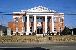 Alleghany County Courthouse | |
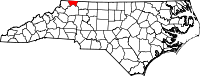 Location in the U.S. state of North Carolina | |
 North Carolina's location in the U.S. | |
| Founded | 1859 |
| Named for | Alleghany Mountains |
| Seat | Sparta |
| Largest town | Sparta |
| Area | |
| • Total | 237 sq mi (614 km2) |
| • Land | 235 sq mi (609 km2) |
| • Water | 1.5 sq mi (4 km2), 0.6% |
| Population | |
| • (2010) | 11,155 |
| • Density | 47/sq mi (18/km2) |
| Congressional district | 5th |
| Time zone | Eastern: UTC−5/−4 |
| Website |
www |

Alleghany /ælɪˈɡeɪniː/[1] County is a county located in the U.S. state of North Carolina. As of the 2010 census, the population was 11,155.[2] Its county seat is Sparta.[3]
History
The county was formed in 1859 from the eastern part of Ashe County, North Carolina. It was named for the Allegheny Mountains. Numerous boundary adjustments have been made since it was established, but none have resulted in new counties.
Geography and climate
According to the U.S. Census Bureau, the county has a total area of 235 square miles (610 km2), of which 235 square miles (610 km2) is land and 1.5 square miles (3.9 km2) (0.6%) is water.[4] It is the fifth-smallest county in North Carolina by total area with just over 235 square miles, ranking 95 out of 100 total counties in the state.[5]
Alleghany County is located in northwestern North Carolina, and its northern border is with the State of Virginia. The county is located entirely within the Appalachian Mountains region of western North Carolina. Most of the county is located atop a rolling plateau that ranges from 2,500 feet (760 m) to 3,000 feet (910 m) above sea level. The southern border of the county drops abruptly nearly 1,500 feet (460 m) to the Foothills region of North Carolina. The plateau is crossed by numerous hills and mountains. The highest point in the county is Peach Bottom Mountain - Catherine Knob at 4,175 feet (1,273 m) above sea level.[6] The major rivers of Alleghany County are the New River, and the Little River; the latter flows through the town of Sparta, the county seat.
Isolated by mountainous terrain from the remainder of North Carolina to the east, Alleghany County was described in the 19th and early 20th centuries as one of the Lost Provinces of North Carolina.[7]
Due to its elevation, Alleghany County enjoys slightly cooler summers than the lowland areas to the east and south, with temperatures seldom rising over 90 °F (32 °C). In the winter, however, temperatures can frequently be colder than would be expected in a southern state. Daytime highs can fall into the teens or lower, and snowfall can be extremely heavy at times. According to USClimateData.com, the average temperature is 52.85 °F (11.58 °C).
Major highways
National protected area
- Blue Ridge Parkway (part)
Law and government
Alleghany County is a member of the regional High Country Council of Governments.
| Year | Republican | Democratic | Third parties |
|---|---|---|---|
| 2016 | 71.8% 3,814 | 24.6% 1,306 | 3.7% 195 |
| 2012 | 66.9% 3,390 | 31.2% 1,583 | 1.9% 94 |
| 2008 | 59.4% 3,124 | 38.4% 2,021 | 2.2% 118 |
| 2004 | 59.7% 2,883 | 39.8% 1,922 | 0.5% 22 |
| 2000 | 58.7% 2,531 | 39.8% 1,715 | 1.6% 67 |
| 1996 | 45.7% 1,936 | 42.5% 1,801 | 11.8% 498 |
| 1992 | 39.2% 1,853 | 48.0% 2,271 | 12.8% 606 |
| 1988 | 51.0% 2,174 | 48.9% 2,087 | 0.1% 3 |
| 1984 | 56.1% 2,589 | 43.6% 2,013 | 0.3% 15 |
| 1980 | 46.3% 1,995 | 51.0% 2,198 | 2.7% 117 |
| 1976 | 37.4% 1,532 | 62.3% 2,550 | 0.3% 14 |
| 1972 | 61.3% 2,158 | 37.0% 1,304 | 1.7% 59 |
| 1968 | 45.8% 1,695 | 29.8% 1,102 | 24.4% 904 |
| 1964 | 39.9% 1,573 | 60.1% 2,368 | |
| 1960 | 48.3% 1,978 | 51.7% 2,121 | |
| 1956 | 50.4% 1,699 | 49.6% 1,670 | |
| 1952 | 49.7% 1,789 | 50.3% 1,809 | |
| 1948 | 42.4% 1,374 | 51.4% 1,667 | 6.2% 200 |
| 1944 | 45.2% 1,495 | 54.8% 1,810 | |
| 1940 | 38.4% 1,217 | 61.6% 1,952 | |
| 1936 | 39.0% 1,498 | 61.0% 2,345 | |
| 1932 | 29.2% 810 | 70.3% 1,951 | 0.5% 15 |
| 1928 | 49.2% 1,368 | 50.8% 1,414 | |
| 1924 | 42.8% 1,234 | 57.0% 1,643 | 0.2% 6 |
| 1920 | 46.0% 1,201 | 54.0% 1,409 | |
| 1916 | 44.6% 641 | 55.4% 796 | |
| 1912 | 18.6% 208 | 58.4% 652 | 22.9% 256 |
Demographics
| Historical population | |||
|---|---|---|---|
| Census | Pop. | %± | |
| 1860 | 3,590 | — | |
| 1870 | 3,691 | 2.8% | |
| 1880 | 5,486 | 48.6% | |
| 1890 | 6,523 | 18.9% | |
| 1900 | 7,759 | 18.9% | |
| 1910 | 7,745 | −0.2% | |
| 1920 | 7,403 | −4.4% | |
| 1930 | 7,186 | −2.9% | |
| 1940 | 8,341 | 16.1% | |
| 1950 | 8,155 | −2.2% | |
| 1960 | 7,734 | −5.2% | |
| 1970 | 8,134 | 5.2% | |
| 1980 | 9,587 | 17.9% | |
| 1990 | 9,590 | 0.0% | |
| 2000 | 10,677 | 11.3% | |
| 2010 | 11,155 | 4.5% | |
| Est. 2016 | 10,848 | [9] | −2.8% |
| U.S. Decennial Census[10] 1790-1960[11] 1900-1990[12] 1990-2000[13] 2010-2013[2] | |||
As of the census[14] of 2000, there were 10,677 people, 4,593 households, and 3,169 families residing in the county. The population density was 46 people per square mile (18/km²). There were 6,412 housing units at an average density of 27 per square mile (11/km²). The racial makeup of the county was 95.69% White, 1.23% Black or African American, 0.26% Native American, 0.20% Asian, 0.01% Pacific Islander, 1.75% from other races, and 0.86% from two or more races. 4.96% of the population were Hispanic or Latino of any race.
There were 4,593 households out of which 24.80% had children under the age of 18 living with them, 58.30% were married couples living together, 7.50% had a female householder with no husband present, and 31.00% were non-families. 27.80% of all households were made up of individuals and 14.00% had someone living alone who was 65 years of age or older. The average household size was 2.28 and the average family size was 2.75.
In the county, the population was spread out with 19.40% under the age of 18, 7.40% from 18 to 24, 26.30% from 25 to 44, 27.70% from 45 to 64, and 19.20% who were 65 years of age or older. The median age was 43 years. For every 100 females there were 97.10 males. For every 100 females age 18 and over, there were 95.50 males.
The median income for a household in the county was $29,244, and the median income for a family was $38,473. Males had a median income of $25,462 versus $18,851 for females. The per capita income for the county was $17,691. About 11.30% of families and 17.20% of the population were below the poverty line, including 20.80% of those under age 18 and 25.00% of those age 65 or over.
Communities
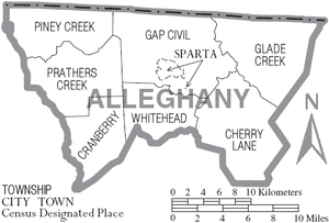
Town
- Sparta (county seat)
Townships
Unincorporated communities
Population ranking
The population ranking of the following table is based on the 2010 census of Alleghany County.[15]
† county seat
| Rank | City/Town/etc. | Municipal type | Population (2010 Census)
|
|---|---|---|---|
| only incorporated community | † Sparta | Town | 1,770 |
Notable people
- Robert L. Doughton (1863–1954), United States Congressman from Alleghany County from 1911–1953. From 1933–1947 he was the Chairman of the House Ways and Means Committee. He used his influence as Chairman to create the Blue Ridge Parkway, which runs along the county's eastern and southern borders. Doughton Park, the largest and most popular park on the Parkway, is named in his honor. He also played a major role in the passage of the Social Security Act.
- Rufus A. Doughton (1857–1946), older brother of Robert Doughton. He served as the Speaker of the North Carolina House of Representatives, and was Lieutenant Governor of North Carolina from 1893-1897.
- Del Reeves (1932–2007), country music entertainer on the United Artists record label. He became a member of the Grand Ole Opry in 1966 and his record "Girl on the Billboard" sold over a million copies.
- Zach Galifianakis (born 1969), stand-up comedian and actor, lives on a farm near Sparta and splits his time between the farm and his work in New York City.
- Bertie Dickens (1902-1994), old-time banjo player who lived most of her life in Ennice, North Carolina. She received the North Carolina Heritage Award in 1992.
See also
References
- ↑ Talk Like A Tarheel, from the North Carolina Collection website at the University of North Carolina at Chapel Hill. Retrieved 2013-01-29.
- 1 2 "State & County QuickFacts". United States Census Bureau. Archived from the original on July 6, 2011. Retrieved October 17, 2013.
- ↑ "Find a County". National Association of Counties. Archived from the original on May 31, 2011. Retrieved 2011-06-07.
- ↑ "2010 Census Gazetteer Files". United States Census Bureau. August 22, 2012. Archived from the original on January 12, 2015. Retrieved January 11, 2015.
- ↑ "North Carolina Land Area County Rank". www.usa.com. Retrieved 2016-02-07.
- ↑ "NC DEQ: NC Geological Survey". www.geology.enr.state.nc.us. Retrieved 2018-03-14.
- ↑ Tabler, Dave (August 30, 2016). "The Lost Provinces". Appalachian History. Retrieved 4 February 2018.
- ↑ Leip, David. "Dave Leip's Atlas of U.S. Presidential Elections". uselectionatlas.org. Retrieved 2018-03-14.
- ↑ "Population and Housing Unit Estimates". Retrieved June 9, 2017.
- ↑ "U.S. Decennial Census". United States Census Bureau. Archived from the original on May 12, 2015. Retrieved January 11, 2015.
- ↑ "Historical Census Browser". University of Virginia Library. Retrieved January 11, 2015.
- ↑ Forstall, Richard L., ed. (March 27, 1995). "Population of Counties by Decennial Census: 1900 to 1990". United States Census Bureau. Retrieved January 11, 2015.
- ↑ "Census 2000 PHC-T-4. Ranking Tables for Counties: 1990 and 2000" (PDF). United States Census Bureau. April 2, 2001. Retrieved January 11, 2015.
- ↑ "American FactFinder". United States Census Bureau. Archived from the original on September 11, 2013. Retrieved 2008-01-31.
- ↑ "Archived copy". Archived from the original on 2013-12-21. Retrieved 2016-02-13.
External links
Coordinates: 36°29′N 81°08′W / 36.49°N 81.13°W
Places adjacent to Alleghany County, North Carolina | ||||||||||
|---|---|---|---|---|---|---|---|---|---|---|
| ||||||||||
Municipalities and communities of Alleghany County, North Carolina, United States | ||
|---|---|---|
| Town | 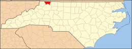 | |
| Townships | ||
| Unincorporated communities | ||
