Stokes County, North Carolina
| Stokes County, North Carolina | ||
|---|---|---|
.jpg) Stokes County Courthouse, Danbury | ||
| ||
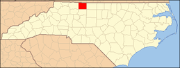
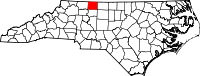 Location in the U.S. state of North Carolina | ||
 North Carolina's location in the U.S. | ||
| Founded | 1789 | |
| Named for | John Stokes | |
| Seat | Danbury | |
| Largest town | King | |
| Area | ||
| • Total | 456 sq mi (1,181 km2) | |
| • Land | 449 sq mi (1,163 km2) | |
| • Water | 6.8 sq mi (18 km2), 1.5% | |
| Population | ||
| • (2010) | 47,401 | |
| • Density | 106/sq mi (41/km2) | |
| Congressional district | 5th | |
| Time zone | Eastern: UTC−5/−4 | |
| Website |
www | |

Stokes County is a county located in the U.S. state of North Carolina. As of the 2010 census, the population was 47,401.[1] Its county seat is Danbury.[2]
Stokes County is included in the Winston-Salem, N.C., Metropolitan Statistical Area, which is also included in the Greensboro-Winston-Salem-High Point, N.C., Combined Statistical Area.
History

The county was formed in 1789 from Surry County. It was named for John Stokes, an American Revolutionary War captain severely wounded when British Colonel Banastre Tarleton's cavalry practically destroyed Col. Abraham Buford's Virginia regiment in the Waxhaws region in 1780. After the war, Captain Stokes was appointed a judge of the United States district court for North Carolina. In 1849 the southern half of Stokes County became Forsyth County.
During the American Civil War, Moratock Iron Furnace located near Danbury served as a foundry for the Confederate Army. It was destroyed in April 1865 when Union cavalry under the command of General George Stoneman conducted extensive raiding through the region.
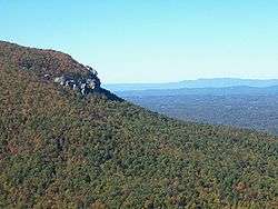
Hanging Rock State Park was formed primarily from blocks of land donated in 1936 and contained 6,921 acres (28.01 km2) in 2005. Many of the facilities in the park were built by the Civilian Conservation Corps between 1935 and 1942. The park is located atop the Sauratown Mountains, and contains a visitor's center, a manmade lake, and plenty of hiking trails, climbing trails, picnic areas, and primitive campgrounds.
Geography
According to the U.S. Census Bureau, the county has a total area of 456 square miles (1,180 km2), of which 449 square miles (1,160 km2) is land and 6.8 square miles (18 km2) (1.5%) is water.[3]
The county lies within the Piedmont region of western North Carolina, and most of the terrain consists of gently rolling countryside. The county is part of Appalachia, though, and the Sauratown Mountains run across the center of the county. The Sauras are named after the Saura Native American tribe which lived in the county before European settlement. A chain of jagged ridges, the Sauratown Mountains are an isolated remnant of the Blue Ridge Mountains far to the west. Although the Sauratown Mountains occupy only 5% of Stokes County, they dominate the scenery from almost any direction, abruptly rising from 800 to 1,700 feet (520 m) above the surrounding terrain. Moore's Knob, the highest point in the chain, rises to 2,579 feet (786 m). Most of the county is less than 1,000 feet (300 m) above sea level. The Dan River runs from the northwest corner to the southeastern section of Stokes County (covering over 56 miles of river recreation). Stokes County is home to Hanging Rock State Park and also has the mass majority of Belews Lake (located in the southeast corner).
Major highways
Demographics
| Historical population | |||
|---|---|---|---|
| Census | Pop. | %± | |
| 1790 | 8,423 | — | |
| 1800 | 11,026 | 30.9% | |
| 1810 | 11,645 | 5.6% | |
| 1820 | 14,033 | 20.5% | |
| 1830 | 16,196 | 15.4% | |
| 1840 | 16,265 | 0.4% | |
| 1850 | 9,206 | −43.4% | |
| 1860 | 10,402 | 13.0% | |
| 1870 | 11,208 | 7.7% | |
| 1880 | 15,353 | 37.0% | |
| 1890 | 17,199 | 12.0% | |
| 1900 | 19,866 | 15.5% | |
| 1910 | 20,151 | 1.4% | |
| 1920 | 20,575 | 2.1% | |
| 1930 | 22,290 | 8.3% | |
| 1940 | 22,656 | 1.6% | |
| 1950 | 21,520 | −5.0% | |
| 1960 | 22,314 | 3.7% | |
| 1970 | 23,782 | 6.6% | |
| 1980 | 33,086 | 39.1% | |
| 1990 | 37,223 | 12.5% | |
| 2000 | 44,712 | 20.1% | |
| 2010 | 47,401 | 6.0% | |
| Est. 2016 | 46,097 | [4] | −2.8% |
| U.S. Decennial Census[5] 1790-1960[6] 1900-1990[7] 1990-2000[8] 2010-2013[1] | |||
As of the census[9] of 2000, there were 44,712 people, 17,579 households, and 13,043 families residing in the county. The population density was 99 people per square mile (38/km²). There were 19,262 housing units at an average density of 43 per square mile (16/km²). The racial makeup of the county was 93.43% White, 4.66% Black or African American, 0.24% Native American, 0.19% Asian, 0.05% Pacific Islander, 0.88% from other races, and 0.54% from two or more races. 1.87% of the population were Hispanic or Latino of any race.
There were 17,579 households out of which 33.80% had children under the age of 18 living with them, 60.60% were married couples living together, 9.70% had a female householder with no husband present, and 25.80% were non-families. 22.80% of all households were made up of individuals and 8.90% had someone living alone who was 65 years of age or older. The average household size was 2.51 and the average family size was 2.94.
In the county, the population was spread out with 24.50% under the age of 18, 7.30% from 18 to 24, 31.40% from 25 to 44, 25.00% from 45 to 64, and 11.80% who were 65 years of age or older. The median age was 37 years. For every 100 females there were 96.10 males. For every 100 females age 18 and over, there were 92.60 males.
The median income for a household in the county was $38,808, and the median income for a family was $44,615. Males had a median income of $30,824 versus $24,319 for females. The per capita income for the county was $18,130. About 6.90% of families and 9.10% of the population were below the poverty line, including 10.00% of those under age 18 and 15.90% of those age 65 or over.
Communities

Cities
- King (also in Forsyth County)
Towns
- Danbury (county seat)
- Walnut Cove
Village
- Tobaccoville (also in Forsyth County)
Census-designated places
Unincorporated communities
- Aarons Corner
- Asbury
- Boyles Chapel
- Brook Cove
- Brown Mountain
- Campbell
- Capella
- Ceramic
- Chestnut Grove
- Collinstown
- Dalton
- Delta
- Dillard
- Dodgetown
- Flat Rock
- Flat Shoals
- Francisco
- Gap
- Hartman
- Lawsonville
- Meadows
- Moores Springs
- Mountain View
- Mount Olive
- Neatman
- Oak Ridge
- Pine Hall
- Poplar Springs
- Prestonville
- Quaker Gap
- Rosebud
- Sandy Ridge
- Volunteer
- Westfield
Townships
Politics, law and government
Stokes is at present a powerfully Republican county. The last Democratic Presidential nominee to carry Stokes County was Jimmy Carter in 1976, and no Democrat since 1984 has reached forty percent of the county’s vote. Indeed, Hillary Clinton barely cracked twenty percent in 2016, receiving a proportion smaller than Hubert Humphrey obtained in the three-way 1968 race. In earlier years Stokes swung from Democratic-leaning during the Third Party System to Republican enough to be alongside Yadkin and Surry as the only North Carolina counties to stick with William Howard Taft during his disastrous 1912 campaign,[10] back to Democratic enough to support Adlai Stevenson II in 1952.
| Year | Republican | Democratic | Third parties |
|---|---|---|---|
| 2016 | 75.9% 17,116 | 20.7% 4,665 | 3.4% 769 |
| 2012 | 70.5% 15,237 | 27.8% 6,018 | 1.7% 364 |
| 2008 | 66.6% 14,488 | 31.6% 6,875 | 1.8% 380 |
| 2004 | 70.0% 13,583 | 29.7% 5,767 | 0.3% 64 |
| 2000 | 70.0% 12,028 | 29.3% 5,030 | 0.7% 124 |
| 1996 | 61.8% 9,471 | 31.1% 4,769 | 7.1% 1,080 |
| 1992 | 47.9% 7,979 | 38.8% 6,463 | 13.3% 2,215 |
| 1988 | 61.8% 8,661 | 38.0% 5,319 | 0.2% 32 |
| 1984 | 65.6% 9,515 | 34.1% 4,950 | 0.2% 33 |
| 1980 | 54.9% 7,275 | 43.5% 5,764 | 1.6% 206 |
| 1976 | 47.4% 6,029 | 52.3% 6,647 | 0.3% 35 |
| 1972 | 66.9% 7,118 | 30.6% 3,254 | 2.6% 274 |
| 1968 | 45.3% 4,781 | 22.5% 2,374 | 32.3% 3,410 |
| 1964 | 48.8% 4,664 | 51.2% 4,898 | |
| 1960 | 52.1% 4,872 | 47.9% 4,487 | |
| 1956 | 52.4% 4,341 | 47.6% 3,948 | |
| 1952 | 45.7% 3,792 | 54.3% 4,504 | |
| 1948 | 41.7% 3,291 | 56.2% 4,431 | 2.1% 169 |
| 1944 | 45.1% 3,376 | 54.9% 4,110 | |
| 1940 | 38.8% 2,712 | 61.2% 4,274 | |
| 1936 | 42.6% 3,259 | 57.4% 4,384 | |
| 1932 | 40.7% 2,577 | 58.8% 3,721 | 0.6% 35 |
| 1928 | 65.6% 3,759 | 34.4% 1,970 | |
| 1924 | 51.3% 2,482 | 47.8% 2,309 | 0.9% 44 |
| 1920 | 59.4% 2,926 | 40.6% 1,999 | |
| 1916 | 53.8% 1,852 | 45.6% 1,569 | 0.6% 21 |
| 1912 | 51.3% 1,450 | 40.5% 1,144 | 8.2% 232 |
Stokes County is a member of the regional Northwest Piedmont Council of Governments. Stokes County government is made up of five elected County Commissioners with an appointed County Manager plus an appointed Tax Administrator. Other Elected Officials are the Sheriff, Clerk of Court, and Register of Deeds. School Board Members are Elected to a five-member Board who appoint a Superintendent and present the budget to County Commissioners for approval.
Economy
Stokes County has long been a "bedroom community" or "commuter town" for larger towns surrounding, such as Winston-Salem, Greensboro, Mount Airy, etc. Stokes County has struggled with economic development for several reasons such as infrastructure. The leaders in the county understand this and are working to create new opportunities and upgrades to enhance growth. Several medium and small businesses have found success in Stokes, as well as retail stores, restaurants, and service professionals. The largest employer in the county is the government/school system.
See also
References
- 1 2 "State & County QuickFacts". United States Census Bureau. Retrieved October 30, 2013.
- ↑ "Find a County". National Association of Counties. Retrieved 2011-06-07.
- ↑ "2010 Census Gazetteer Files". United States Census Bureau. August 22, 2012. Archived from the original on January 12, 2015. Retrieved January 19, 2015.
- ↑ "Population and Housing Unit Estimates". Retrieved June 9, 2017.
- ↑ "U.S. Decennial Census". United States Census Bureau. Retrieved January 19, 2015.
- ↑ "Historical Census Browser". University of Virginia Library. Retrieved January 19, 2015.
- ↑ Forstall, Richard L., ed. (March 27, 1995). "Population of Counties by Decennial Census: 1900 to 1990". United States Census Bureau. Retrieved January 19, 2015.
- ↑ "Census 2000 PHC-T-4. Ranking Tables for Counties: 1990 and 2000" (PDF). United States Census Bureau. April 2, 2001. Retrieved January 19, 2015.
- ↑ "American FactFinder". United States Census Bureau. Retrieved 2008-01-31.
- ↑ Menendez, Albert J.; The Geography of Presidential Elections in the United States, 1868-2004, pp. 265-271 ISBN 0786422173
- ↑ Leip, David. "Dave Leip's Atlas of U.S. Presidential Elections". uselectionatlas.org. Retrieved 2018-03-17.
External links
| Wikimedia Commons has media related to Stokes County, North Carolina. |
- Stokes County government official website
- Stokes EDC
- Visitors Information
- Stokes Arts Council
- Foothills Hayride
- Stokes County Historical Society
- NCGenWeb Stokes County - free genealogy resources for the county
Places adjacent to Stokes County, North Carolina | ||||||||||
|---|---|---|---|---|---|---|---|---|---|---|
| ||||||||||
Municipalities and communities of Stokes County, North Carolina, United States | ||
|---|---|---|
| City |
|  |
| Towns | ||
| Village | ||
| Townships | ||
| CDPs | ||
| Other unincorporated communities |
| |
| Footnotes | ‡This populated place also has portions in an adjacent county or counties. | |
