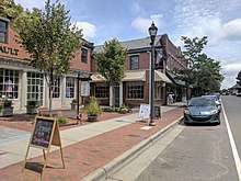
Southern Pines, North Carolina
| Southern Pines, North Carolina | |
|---|---|
| Town | |
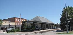 Amtrak Station in Southern Pines | |
 Location in Moore County and the state of North Carolina. | |
| Coordinates: 35°10′55″N 79°23′54″W / 35.18194°N 79.39833°WCoordinates: 35°10′55″N 79°23′54″W / 35.18194°N 79.39833°W | |
| Country | United States |
| State | North Carolina |
| County | Moore |
| Government | |
| • Mayor | David McNeil |
| Area | |
| • Total | 15.5 sq mi (40.2 km2) |
| • Land | 15.4 sq mi (39.8 km2) |
| • Water | 0.2 sq mi (0.5 km2) |
| Elevation | 535 ft (163 m) |
| Population (2010) | |
| • Total | 12,334 |
| • Estimate (2016)[1] | 13,782 |
| • Density | 800/sq mi (310/km2) |
| Time zone | UTC−5 (Eastern (EST)) |
| • Summer (DST) | UTC−4 (EDT) |
| ZIP codes | 28387-28388 |
| Area code(s) | 910 |
| FIPS code | 37-63120[2] |
| GNIS feature ID | 0995240[3] |
| Website | www.southernpines.net |
Southern Pines is a town in Moore County, North Carolina, United States. The population was 12,334 as of the 2010 United States Census.
History
The James Boyd House, Shaw House, Southern Pines Historic District, Firleigh Farms, and Moore County Hunt Lands and Mile-Away Farms are listed on the National Register of Historic Places.[4][5][6]
Geography
According to the United States Census Bureau, the town has a total area of 15.5 square miles (40.2 km²), of which 15.4 square miles (39.8 km²) is land and 0.2 square mile (0.5 km²) (1.16%) is water.
Demographics
| Historical population | |||
|---|---|---|---|
| Census | Pop. | %± | |
| 1900 | 517 | — | |
| 1910 | 542 | 4.8% | |
| 1920 | 743 | 37.1% | |
| 1930 | 2,524 | 239.7% | |
| 1940 | 3,225 | 27.8% | |
| 1950 | 4,272 | 32.5% | |
| 1960 | 5,198 | 21.7% | |
| 1970 | 5,937 | 14.2% | |
| 1980 | 8,620 | 45.2% | |
| 1990 | 9,129 | 5.9% | |
| 2000 | 10,918 | 19.6% | |
| 2010 | 12,334 | 13.0% | |
| Est. 2016 | 13,782 | [1] | 11.7% |
| U.S. Decennial Census[7] | |||
As of the 2010 census,[2] there were 12,334 people, 5,866 households, and 3,304 families residing in the town. The population density was 806 people per square mile (311.2/km²). There were 6,859 housing units at an average density of 371 houses/condos per square mile (143.24/km²). The racial makeup of the town was 71.7% White, 24% African American, 0.6% Native American, 0.8% Asian, 0.1% Pacific Islander, 1.3% from other races, and 1.4% from two or more races. Hispanic or Latino of any race were 1.4% of the population.[8]
Of the 5,866 households, 21% had children under the age of 18 living with them, 40.6% were married couples living together, 13% had a female householder with no husband present, 2.7 had a male householder with no female present, and 38.9% were non-families. The average household size was 2.07 and the average family size was 2.75.[8]
In the town, the population was spread out with 21.9% aged 19 and younger, 4.7% from 20 to 24, 20.8% from 25 to 44, 25.2% from 45 to 64, and 27.5% who were 65 years of age or older. The median age was 47. For every 100 females, there were 82 males. For every 100 females age 18 and over, there were 78.2 males.[8]
The median income for a household in the town was $41,297 in 2011,[9] and the median income for a family was $60,683.[10] Males had a median income of $29,855 versus $23,920 for females. The per capita income for the town was $30,886.[10] Of families, 9.26% were below the poverty level, along with 12.4% of the population poverty line, including 23.0% of those under age 18 and 9.6% of those age 65 or over.
Education
- The O'Neal School
- Pinecrest High School
- St. John Paul II Catholic School
- Episcopal Day School
- Sandhills Classical Christian School
- Academy of Classical Design - Fine Art Atelier
- Calvary Christian School
- Sandhills Community College
- North Moore High School
- Union Pines High School
Media
- Southern Pines Pilot
- WYBE Sandhills Lifetime TV 44
- WEEB Talk Radio 990 AM and 97.3 FM
- WIOZ Star 102.5 FM
- WMGU Magic 106.9 FM
- WMAG 99.5 Winston-Salem, Greensboro, High-Point
- WQSM 98.1 Q98 Fayetteville
The metro area has TV broadcasting stations that serve the Raleigh-Durham Designated Market Area (DMA) as defined by Nielsen Media Research.
Infrastructure
Transportation
Notable people
- James Baldwin – former All-Star pitcher for the Chicago White Sox; graduate of Pinecrest High School
- PT Barnum built a home for his family in Southern Pines at 285 N. Bethesda Rd.
- Peggy Kirk Bell – golf instructor, and founding member of the LPGA
- Sarah Dessen – New York Times bestseller author
- James Holshouser, Jr. – former Republican Governor of North Carolina
- Sandy Koufax – Hall of Fame pitcher for the Los Angeles Dodgers formerly owned a home in Southern Pines
- Carwood Lipton - member 101st Airborne in World War II, portrayed in 'Band of Brothers', spent his retirement years in Southern Pines
- Jeffrey Mims – artist, and founder of Academy of Classical Design
- Shannon Moore – professional wrestler
- Richard T. Morgan - North Carolina state legislator, businessman, and farmer
- Winant Sidle – U.S. Army Major General
- John Frank Stevens – railroad builder, discoverer of Stevens Pass, and lead engineer for the Panama Canal
- Michael Walsh - Horse Trainer and founder of the Stoneybrook Steeplechase, National Horse Racing Hall of Fame inductee
References
- 1 2 "Population and Housing Unit Estimates". Retrieved June 9, 2017.
- 1 2 "American FactFinder". United States Census Bureau. Retrieved 2008-01-31.
- ↑ "US Board on Geographic Names". United States Geological Survey. 2007-10-25. Retrieved 2008-01-31.
- ↑ National Park Service (2010-07-09). "National Register Information System". National Register of Historic Places. National Park Service.
- ↑ "National Register of Historic Places Listings". Weekly List of Actions Taken on Properties, 9/09/13 through 9/13/13. National Park Service. 2013-09-20.
- ↑ "National Register of Historic Places Listings". Weekly List of Actions Taken on Properties: 5/29/14 through 5/23/14. National Park Service. 2014-05-30.
- ↑ "Census of Population and Housing". Census.gov. Retrieved June 4, 2015.
- 1 2 3 "2010 Census data for City of Southern Pines, NC". www.zip-codes.com. Retrieved 6 April 2018.
- ↑ "Southern Pines, North Carolina (NC 28387) profile: population, maps, real estate, averages, homes, statistics, relocation, travel, jobs, hospitals, schools, crime, moving, houses, news, sex offenders". www.city-data.com. Retrieved 6 April 2018.
- 1 2 "Southern Pines, NC Income and Careers - USA.com™". www.usa.com. Retrieved 6 April 2018.
External links
Municipalities and communities of Moore County, North Carolina, United States | ||
|---|---|---|
| City | 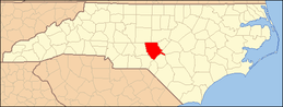 | |
| Towns | ||
| Villages | ||
| CDP | ||
| Unincorporated communities | ||
