Alexander County, North Carolina
| Alexander County, North Carolina | ||
|---|---|---|
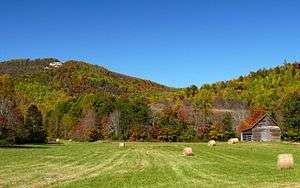 The Brushy Mountains in Alexander County | ||
| ||
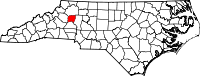 Location in the U.S. state of North Carolina | ||
 North Carolina's location in the U.S. | ||
| Founded | 1847 | |
| Named for | William Julius Alexander | |
| Seat | Taylorsville | |
| Largest town | Taylorsville | |
| Area | ||
| • Total | 264 sq mi (684 km2) | |
| • Land | 260 sq mi (673 km2) | |
| • Water | 3.7 sq mi (10 km2), 1.4% | |
| Population | ||
| • (2010) | 37,198 | |
| • Density | 143/sq mi (55/km2) | |
| Congressional district | 5th | |
| Time zone | Eastern: UTC−5/−4 | |
| Website |
alexandercountync | |

Alexander County is a county in the U.S. state of North Carolina. As of the 2010 census, the population was 37,198.[1] Its county seat is Taylorsville.[2]
Alexander County is part of the Hickory–Lenoir–Morganton, NC Metropolitan Statistical Area.
History
Alexander County was chartered in 1847 by the North Carolina General Assembly. It was formed from portions of what were then Iredell, Caldwell, Wilkes counties.[3] The county was named for William Julius Alexander who was a Speaker of the North Carolina House of Commons.[4] This Piedmont area was settled primarily by farmers, many of Scots-Irish descent.
Alexander County was established in 1847, the year of the first sale of land in the county seat (Taylorsville). With the proceeds from the sale, the county built the first courthouse on the present site. When the American Civil War began, Alexander County was fourteen years old. The 1860 population was 5,837; yet Alexander County ranked high per capita in the number of Confederate soldiers it sent to the war. Taylorsville is the namesake of either John Louis Taylor, Carolina agriculturist and political philosopher, or General Zachary Taylor, the twelfth president of the United States.
Geography
According to the U.S. Census Bureau, the county has a total area of 264 square miles (680 km2), of which 260 square miles (670 km2) is land and 3.7 square miles (9.6 km2) (1.4%) is water.[5]
Alexander County is located within the Piedmont region of western North Carolina. The county's main geographic feature is the Brushy Mountains, a deeply eroded spur of the Blue Ridge Mountains to the west. The "Brushies," as they are called locally, rise from 300 to 1,000 feet (300 m) above the surrounding countryside, and dominate the county's northern horizon. The highest point in Alexander County is Hickory Knob in the Brushies; it has an elevation of 2,560 feet (780 m) above sea level. Barrett Mountain, an isolated mountain ridge, is in the western part of the county. The remainder of Alexander County's terrain consists of gently rolling countryside. The county's largest river, the Catawba, forms its southern border.
Within Alexander County is the unincorporated town of Hiddenite, the location of a mine that yields emeralds, sapphires, and its namesake stone "hiddenite," a variety of spodumene.
The county is served by US Highway 64, a controlled-access roadway connecting Taylorsville with Lenoir and Statesville. NC Highways 90, 16, and 127 also serve the county. Interstate 40 and 77 are 30 minutes from the majority of county residents. The Charlotte Douglas International Airport is an hour's drive from most parts of the county. The area is also served by the Hickory Regional Airport (30 minutes) and the Statesville Airport (20 minutes). The Alexander Railroad Company is an active short-line rail system operating between Taylorsville and Statesville, and connecting with Norfolk Southern.
Demographics
| Historical population | |||
|---|---|---|---|
| Census | Pop. | %± | |
| 1850 | 5,220 | — | |
| 1860 | 6,022 | 15.4% | |
| 1870 | 6,868 | 14.0% | |
| 1880 | 8,355 | 21.7% | |
| 1890 | 9,430 | 12.9% | |
| 1900 | 10,960 | 16.2% | |
| 1910 | 11,592 | 5.8% | |
| 1920 | 12,212 | 5.3% | |
| 1930 | 12,922 | 5.8% | |
| 1940 | 13,454 | 4.1% | |
| 1950 | 14,554 | 8.2% | |
| 1960 | 15,625 | 7.4% | |
| 1970 | 19,466 | 24.6% | |
| 1980 | 24,999 | 28.4% | |
| 1990 | 27,544 | 10.2% | |
| 2000 | 33,603 | 22.0% | |
| 2010 | 37,198 | 10.7% | |
| Est. 2016 | 37,428 | [6] | 0.6% |
| U.S. Decennial Census[7] 1790-1960[8] 1900-1990[9] 1990-2000[10] 2010-2014[1] | |||
As of the census[11] of 2000, there were 33,603 people, 13,137 households, and 9,747 families residing in the county. The population density was 129 people per square mile (50/km²). There were 14,098 housing units at an average density of 54 per square mile (21/km²). The racial makeup of the county was 92.00% White, 4.63% Black or African American, 0.15% Native American, 1.04% Asian, 1.34% from other races, and 0.84% from two or more races. 2.50% of the population were Hispanic or Latino of any race.
There were 13,137 households out of which 32.80% had children under the age of 18 living with them, 60.50% were married couples living together, 9.40% had a female householder with no husband present, and 25.80% were non-families. 21.90% of all households were made up of individuals and 8.40% had someone living alone who was 65 years of age or older. The average household size was 2.54 and the average family size was 2.95.
In the county, the population was spread out with 24.50% under the age of 18, 7.90% from 18 to 24, 31.10% from 25 to 44, 24.60% from 45 to 64, and 11.90% who were 65 years of age or older. The median age was 37 years. For every 100 females there were 99.40 males. For every 100 females age 18 and over, there were 96.70 males.
The median income for a household in the county was $38,684, and the median income for a family was $45,691. Males had a median income of $29,857 versus $21,868 for females. The per capita income for the county was $18,507. About 5.90% of families and 8.50% of the population were below the poverty line, including 10.20% of those under age 18 and 14.60% of those age 65 or over.
Communities

Town
- Taylorsville (county seat)
Townships
The county is divided into eight townships: Bethelehem, Ellendale, Gwaltney, Little River, Sugar Loaf, Taylorsville, Wittenburg, and Stony Point.
Census-designated places
Unincorporated communities
- Drumstand
- Vashti
- Ellendale
- Wittenburg
- Sugar Loaf
- Little River
- Millersville
Population ranking
The population ranking of the following table is based on the 2010 census of Alexander County.[12]
† county seat
| Rank | City/Town/etc. | Municipal type | Population (2010 Census)
|
|---|---|---|---|
| 1 | Bethlehem | CDP | 4,214 |
| 2 | † Taylorsville | Town | 2,098 |
| 3 | Stony Point (partially in Iredell County) | CDP | 1,317 |
| 4 | Hiddenite | CDP | 536 |
Politics, law and government
Alexander is currently a powerfully Republican county in Presidential elections. The only Democrat to carry the county in the past nineteen Presidential contests has been Jimmy Carter in 1976, although Barry Goldwater won the county be a mere thirty-eight votes in 1964. In contrast, Hillary Clinton in 2016 obtained barely twenty percent of the county's vote. The county did vote mainly Democratic during the Third Party System, but Populist sentiments in the 1890s have meant the county has supported that party only five times since 1896.
| Year | Republican | Democratic | Third parties |
|---|---|---|---|
| 2016 | 76.0% 13,893 | 20.6% 3,767 | 3.3% 611 |
| 2012 | 71.3% 12,253 | 26.8% 4,611 | 1.9% 332 |
| 2008 | 68.3% 11,790 | 30.0% 5,167 | 1.7% 297 |
| 2004 | 70.1% 10,928 | 29.6% 4,618 | 0.4% 54 |
| 2000 | 68.5% 9,242 | 30.9% 4,166 | 0.6% 84 |
| 1996 | 57.5% 6,748 | 33.7% 3,955 | 8.8% 1,027 |
| 1992 | 49.6% 6,764 | 35.6% 4,849 | 14.8% 2,013 |
| 1988 | 65.6% 7,968 | 34.1% 4,148 | 0.3% 38 |
| 1984 | 70.2% 8,502 | 29.6% 3,581 | 0.2% 24 |
| 1980 | 57.4% 6,376 | 40.9% 4,546 | 1.7% 187 |
| 1976 | 46.7% 4,661 | 53.0% 5,287 | 0.3% 27 |
| 1972 | 69.0% 5,865 | 29.0% 2,468 | 2.0% 173 |
| 1968 | 52.0% 4,379 | 21.8% 1,834 | 26.2% 2,203 |
| 1964 | 50.3% 3,760 | 49.8% 3,722 | |
| 1960 | 51.4% 4,175 | 48.7% 3,956 | |
| 1956 | 58.2% 3,767 | 41.8% 2,710 | |
| 1952 | 57.4% 3,597 | 42.6% 2,665 | |
| 1948 | 48.0% 2,314 | 42.7% 2,057 | 9.4% 452 |
| 1944 | 56.6% 2,971 | 43.4% 2,282 | |
| 1940 | 44.7% 2,217 | 55.3% 2,739 | |
| 1936 | 42.9% 2,451 | 57.1% 3,262 | |
| 1932 | 39.6% 1,952 | 59.9% 2,953 | 0.6% 28 |
| 1928 | 60.2% 2,605 | 39.8% 1,722 | |
| 1924 | 51.3% 2,437 | 48.3% 2,291 | 0.4% 20 |
| 1920 | 56.4% 2,643 | 43.6% 2,045 | |
| 1916 | 55.4% 1,187 | 44.6% 954 | |
| 1912 | 27.9% 523 | 45.5% 852 | 26.6% 497 |
Alexander County is a member of the regional Western Piedmont Council of Governments.
Transportation
Major highways
Railroads
The county is served by one railroad, the Alexander Railroad Company.
Notable people
- Harry Gant (retired NASCAR driver)
- Harry Deal and the Galaxies (longtime "beach music" rock group)
- James Best (Actor)(deceased 2015)
- Jerry Rushing (Bootlegger, Inspiration for "Dukes of Hazzard"_deceased 2017)
See also
References
- 1 2 "State & County QuickFacts". United States Census Bureau. Archived from the original on July 6, 2011. Retrieved October 17, 2013.
- ↑ "Find a County". National Association of Counties. Archived from the original on 2011-05-31. Retrieved 2011-06-07.
- ↑ Crouse, A. L. (1905). Historical Sketches of Alexander County. Hickory, North Carolina.
- ↑ Martin, Jonathan. "Alexander County (1847)". North Carolina History Project. John Locke Foundation. Retrieved December 8, 2012.
- ↑ "2010 Census Gazetteer Files". United States Census Bureau. August 22, 2012. Archived from the original on January 12, 2015. Retrieved January 11, 2015.
- ↑ "Population and Housing Unit Estimates". Retrieved June 9, 2017.
- ↑ "U.S. Decennial Census". United States Census Bureau. Archived from the original on May 12, 2015. Retrieved January 11, 2015.
- ↑ "Historical Census Browser". University of Virginia Library. Retrieved January 11, 2015.
- ↑ Forstall, Richard L., ed. (March 27, 1995). "Population of Counties by Decennial Census: 1900 to 1990". United States Census Bureau. Retrieved January 11, 2015.
- ↑ "Census 2000 PHC-T-4. Ranking Tables for Counties: 1990 and 2000" (PDF). United States Census Bureau. Retrieved January 11, 2015.
- ↑ "American FactFinder". United States Census Bureau. Archived from the original on 2013-09-11. Retrieved 2008-01-31.
- ↑ Promotions, Center for New Media and. "US Census Bureau 2010 Census". www.census.gov. Retrieved 2018-03-14.
- ↑ Leip, David. "Dave Leip's Atlas of U.S. Presidential Elections". uselectionatlas.org. Retrieved 2018-03-14.
External links
Places adjacent to Alexander County, North Carolina | ||||||||||
|---|---|---|---|---|---|---|---|---|---|---|
| ||||||||||
Municipalities and communities of Alexander County, North Carolina, United States | ||
|---|---|---|
| Town | 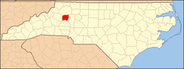 | |
| CDPs | ||
| Footnotes | ‡This populated place also has portions in an adjacent county or counties | |
