Washington County, North Carolina
| Washington County, North Carolina | |
|---|---|
 | |
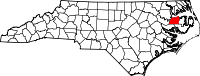 Location in the U.S. state of North Carolina | |
 North Carolina's location in the U.S. | |
| Founded | 1799 |
| Named for | George Washington |
| Seat | Plymouth |
| Largest town | Plymouth |
| Area | |
| • Total | 424 sq mi (1,098 km2) |
| • Land | 348 sq mi (901 km2) |
| • Water | 76 sq mi (197 km2), 18% |
| Population (est.) | |
| • (2013) | 12,722 |
| • Density | 38/sq mi (15/km2) |
| Congressional district | 1st |
| Time zone | Eastern: UTC−5/−4 |
| Website |
www |
Washington County is a county located in the U.S. state of North Carolina. As of the 2010 Census, the population was 13,228.[1] Its county seat is Plymouth.[2] The county was formed in 1799 from the western third of Tyrrell County. It was named for George Washington.
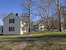
There are three incorporated towns in Washington County. Plymouth is the county seat. Other towns are Roper and Creswell. Washington County is known for rich farmland, extensive forests and abundant public access waters. The Roanoke River and Albemarle Sound form the northern boundary. Lake Phelps is 16,000 acres and is part of Pettigrew State Park in Creswell. Somerset Place is a restored antebellum plantation and NC Historic Site on Lake Phelps.
The Pungo Unit of the Pocosin Lakes National Wildlife Refuge in the southern part of the county is said to have the best public black bear viewing in North Carolina. This part of the State is known for having the world's largest black bears and highest black bear densities, according to the NC Black Bear Biologist, Colleen Olfenbuttel. The award-winning NC Black Bear Festival takes place in Plymouth on the first weekend in June.
Geography
According to the U.S. Census Bureau, the county has a total area of 424 square miles (1,100 km2), of which 348 square miles (900 km2) is land and 76 square miles (200 km2) (18%) is water.[3] The county borders the Albemarle Sound.
Adjacent counties
- Chowan County - north
- Perquimans County - northeast
- Tyrrell County - east
- Hyde County - southeast
- Beaufort County - southwest
- Martin County - west
- Bertie County - northwest
National protected area
Major highways
Demographics
| Historical population | |||
|---|---|---|---|
| Census | Pop. | %± | |
| 1800 | 2,422 | — | |
| 1810 | 3,464 | 43.0% | |
| 1820 | 3,986 | 15.1% | |
| 1830 | 4,552 | 14.2% | |
| 1840 | 4,525 | −0.6% | |
| 1850 | 5,664 | 25.2% | |
| 1860 | 6,357 | 12.2% | |
| 1870 | 6,516 | 2.5% | |
| 1880 | 8,928 | 37.0% | |
| 1890 | 10,200 | 14.2% | |
| 1900 | 10,608 | 4.0% | |
| 1910 | 11,062 | 4.3% | |
| 1920 | 11,429 | 3.3% | |
| 1930 | 11,603 | 1.5% | |
| 1940 | 12,323 | 6.2% | |
| 1950 | 13,180 | 7.0% | |
| 1960 | 13,488 | 2.3% | |
| 1970 | 14,038 | 4.1% | |
| 1980 | 14,801 | 5.4% | |
| 1990 | 13,997 | −5.4% | |
| 2000 | 13,723 | −2.0% | |
| 2010 | 13,228 | −3.6% | |
| Est. 2016 | 12,195 | [4] | −7.8% |
| U.S. Decennial Census[5] 1790-1960[6] 1900-1990[7] 1990-2000[8] 2010-2013[1] | |||
As of the census[9] of 2000, there were 13,723 people, 5,367 households, and 3,907 families residing in the county. The population density was 39 people per square mile (15/km²). There were 6,174 housing units at an average density of 18 per square mile (7/km²). The racial makeup of the county was 48.28% White, 48.94% Black or African American, 0.05% Native American, 0.32% Asian, 0.04% Pacific Islander, 1.66% from other races, and 0.70% from two or more races. 2.27% of the population were Hispanic or Latino of any race.
There were 5,367 households out of which 31.70% had children under the age of 18 living with them, 50.10% were married couples living together, 18.80% had a female householder with no husband present, and 27.20% were non-families. 24.70% of all households were made up of individuals and 11.70% had someone living alone who was 65 years of age or older. The average household size was 2.52 and the average family size was 2.99.
In the county, the population was spread out with 26.00% under the age of 18, 7.70% from 18 to 24, 25.00% from 25 to 44, 25.80% from 45 to 64, and 15.50% who were 65 years of age or older. The median age was 39 years. For every 100 females there were 89.70 males. For every 100 females age 18 and over, there were 86.10 males.
The median income for a household in the county was $28,865, and the median income for a family was $34,888. Males had a median income of $27,058 versus $19,477 for females. The per capita income for the county was $14,994. About 17.60% of families and 21.80% of the population were below the poverty line, including 31.50% of those under age 18 and 19.20% of those age 65 or over.
Law and government
Washington County is a member of the Albemarle Commission regional council of governments.
Washington County is one of the proposed sites for a Navy outlying landing field. This practice airfield would allow pilots to simulate landings on an aircraft carrier. Construction, which has not yet begun, is controversial due to its potential ecological impact.
| Year | Republican | Democratic | Third parties |
|---|---|---|---|
| 2016 | 41.6% 2,564 | 56.9% 3,510 | 1.5% 91 |
| 2012 | 40.3% 2,622 | 59.0% 3,833 | 0.7% 44 |
| 2008 | 41.4% 2,670 | 58.1% 3,748 | 0.6% 36 |
| 2004 | 45.4% 2,484 | 54.3% 2,969 | 0.3% 18 |
| 2000 | 44.4% 2,169 | 55.3% 2,704 | 0.4% 17 |
| 1996 | 34.5% 1,562 | 61.6% 2,790 | 4.0% 180 |
| 1992 | 33.9% 1,780 | 55.2% 2,902 | 10.9% 571 |
| 1988 | 43.7% 2,186 | 56.1% 2,806 | 0.2% 12 |
| 1984 | 46.7% 2,731 | 53.2% 3,114 | 0.1% 7 |
| 1980 | 38.6% 1,943 | 59.7% 3,008 | 1.7% 86 |
| 1976 | 34.1% 1,486 | 65.1% 2,840 | 0.8% 35 |
| 1972 | 61.7% 2,559 | 37.2% 1,546 | 1.1% 46 |
| 1968 | 21.3% 1,016 | 39.7% 1,898 | 39.0% 1,866 |
| 1964 | 31.4% 1,144 | 68.7% 2,505 | |
| 1960 | 29.8% 1,027 | 70.2% 2,415 | |
| 1956 | 34.7% 1,033 | 65.3% 1,947 | |
| 1952 | 28.2% 774 | 71.8% 1,974 | |
| 1948 | 16.2% 333 | 81.4% 1,675 | 2.4% 49 |
| 1944 | 21.8% 497 | 78.2% 1,782 | |
| 1940 | 17.4% 362 | 82.7% 1,724 | |
| 1936 | 22.2% 535 | 77.8% 1,875 | |
| 1932 | 26.8% 619 | 72.7% 1,681 | 0.5% 12 |
| 1928 | 56.9% 1,183 | 43.2% 898 | |
| 1924 | 48.4% 834 | 51.3% 883 | 0.4% 6 |
| 1920 | 46.5% 971 | 53.5% 1,116 | |
| 1916 | 42.7% 486 | 57.3% 651 | |
| 1912 | 37.1% 384 | 48.6% 503 | 14.4% 149 |
Education
Communities

Towns
Unincorporated communities
Townships
- Plymouth
- Lees Mill
- Scuppernong
- Skinnersville
See also
References
- 1 2 "State & County QuickFacts". United States Census Bureau. Retrieved October 30, 2013.
- ↑ "Find a County". National Association of Counties. Retrieved 2011-06-07.
- ↑ "2010 Census Gazetteer Files". United States Census Bureau. August 22, 2012. Archived from the original on January 12, 2015. Retrieved January 20, 2015.
- ↑ "Population and Housing Unit Estimates". Retrieved June 9, 2017.
- ↑ "U.S. Decennial Census". United States Census Bureau. Retrieved January 20, 2015.
- ↑ "Historical Census Browser". University of Virginia Library. Retrieved January 20, 2015.
- ↑ Forstall, Richard L., ed. (March 27, 1995). "Population of Counties by Decennial Census: 1900 to 1990". United States Census Bureau. Retrieved January 20, 2015.
- ↑ "Census 2000 PHC-T-4. Ranking Tables for Counties: 1990 and 2000" (PDF). United States Census Bureau. April 2, 2001. Retrieved January 20, 2015.
- ↑ "American FactFinder". United States Census Bureau. Retrieved 2008-01-31.
- ↑ Leip, David. "Dave Leip's Atlas of U.S. Presidential Elections". uselectionatlas.org. Retrieved 2018-03-17.
External links
Places adjacent to Washington County, North Carolina | ||||||||||
|---|---|---|---|---|---|---|---|---|---|---|
| ||||||||||
Municipalities and communities of Washington County, North Carolina, United States | ||
|---|---|---|
| Towns |  | |
| Unincorporated communities | ||
