Yadkin County, North Carolina
| Yadkin County, North Carolina | ||
|---|---|---|
 | ||
| ||
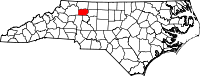 Location in the U.S. state of North Carolina | ||
 North Carolina's location in the U.S. | ||
| Founded | 1850 | |
| Named for | Yadkin River | |
| Seat | Yadkinville | |
| Largest town | Yadkinville | |
| Area | ||
| • Total | 338 sq mi (875 km2) | |
| • Land | 335 sq mi (868 km2) | |
| • Water | 2.7 sq mi (7 km2), 0.8% | |
| Population | ||
| • (2010) | 38,406 | |
| • Density | 115/sq mi (44/km2) | |
| Congressional district | 5th | |
| Time zone | Eastern: UTC−5/−4 | |
| Website |
www | |

Yadkin County is a county located in the U.S. state of North Carolina. As of the 2010 census, the population was 38,406.[1] Its county seat is Yadkinville.[2]
Yadkin County is included in the Winston-Salem, NC Metropolitan Statistical Area, which is also included in the Greensboro-Winston-Salem-High Point, NC Combined Statistical Area.
History
The county was formed in 1850 from the part of Surry County south of the Yadkin River, for which it was named.
Geography
According to the U.S. Census Bureau, the county has a total area of 338 square miles (880 km2), of which 335 square miles (870 km2) is land and 2.7 square miles (7.0 km2) (0.8%) is water.[3]
Yadkin County is located in the Piedmont region of central North Carolina. The Piedmont consists of rolling farmlands frequently broken by hills or valleys formed by streams. The extreme western section of the county contains the Brushy Mountains, a deeply eroded spur of the much higher Blue Ridge Mountains to the west. Yadkin County marks the eastern end of the Brushy Mountains range; none of the peaks rise more than 400–500 feet above the surrounding countryside. The highest point in the county is Star Peak near Jonesville, at 1,590 feet above sea level.
The Yadkin River forms the county's northern and eastern borders. The county takes its name from the river.
Adjacent counties
- Surry County – north
- Forsyth County – east
- Davie County – south-southeast
- Iredell County – south-southwest
- Wilkes County – west
Demographics
| Historical population | |||
|---|---|---|---|
| Census | Pop. | %± | |
| 1860 | 10,714 | — | |
| 1870 | 10,697 | −0.2% | |
| 1880 | 12,420 | 16.1% | |
| 1890 | 13,790 | 11.0% | |
| 1900 | 14,083 | 2.1% | |
| 1910 | 15,428 | 9.6% | |
| 1920 | 16,391 | 6.2% | |
| 1930 | 18,010 | 9.9% | |
| 1940 | 20,657 | 14.7% | |
| 1950 | 22,133 | 7.1% | |
| 1960 | 22,804 | 3.0% | |
| 1970 | 24,599 | 7.9% | |
| 1980 | 28,439 | 15.6% | |
| 1990 | 30,488 | 7.2% | |
| 2000 | 36,348 | 19.2% | |
| 2010 | 38,406 | 5.7% | |
| Est. 2016 | 37,532 | [4] | −2.3% |
| U.S. Decennial Census[5] 1790–1960[6] 1900–1990[7] 1990–2000[8] 2010–2013[1] | |||
As of the census[9] of 2000, there were 36,348 people, 14,505 households, and 10,588 families residing in the county. The population density was 108 people per square mile (42/km²). There were 15,821 housing units at an average density of 47 per square mile (18/km²). The racial makeup of the county was 92.54% White, 3.43% Black or African American, 0.16% Native American, 0.17% Asian, 0.02% Pacific Islander, 2.91% from other races, and 0.77% from two or more races. 6.48% of the population were Hispanic or Latino of any race.
There were 14,505 households out of which 32.10% had children under the age of 18 living with them, 60.00% were married couples living together, 9.00% had a female householder with no husband present, and 27.00% were non-families. 24.00% of all households were made up of individuals and 10.50% had someone living alone who was 65 years of age or older. The average household size was 2.47 and the average family size was 2.92.
In the county, the population was spread out with 24.00% under the age of 18, 7.50% from 18 to 24, 30.20% from 25 to 44, 24.20% from 45 to 64, and 14.20% who were 65 years of age or older. The median age was 38 years. For every 100 females there were 96.40 males. For every 100 females age 18 and over, there were 93.60 males.
The median income for a household in the county was $36,660, and the median income for a family was $43,758. Males had a median income of $29,589 versus $22,599 for females. The per capita income for the county was $18,576. About 7.10% of families and 10.00% of the population were below the poverty line, including 10.90% of those under age 18 and 17.40% of those age 65 or over.
Communities
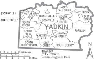
Towns
- Boonville
- East Bend
- Jonesville
- Yadkinville (county seat)
Townships
Unincorporated communities
- Barney Hill
- Branon
- Buck Shoals
- Center
- Brooks' Crossroads
- Courtney
- Enon
- Flint Hill
- Footville
- Forbush
- Hamptonville
- Huntsville
- Lone Hickory
- Longtown
- Marler
- Richmond Hill
- Swan Creek
- Union Hill
- Windsor's Crossroads
- Wyo
Former towns
These towns were incorporated at one time:[10]
- Arlington, merged with Jonesville in 2001.
- Hamptonville, chartered in 1818.
- Huntsville, incorporated in 1792.
- Shore, incorporated from 1903–1911.
- Smithtown, incorporated in 1924.
Politics, law and government
Owing to its Quaker past[11] and consequent historical Unionist sympathies,[12] Yadkin County became and has always remained solidly Republican. The county has voted for the Republican Presidential nominee in every election since that party first contested North Carolina in the 1868 election,[13] being alongside Stokes County and Surry County one of only three North Carolina counties to remain loyal to William Howard Taft in 1912, and one of seven to vote for Alf Landon in 1936. Even before the Republican Party contested the South, Yadkin County never voted Democratic: it voted for Constitutional Union candidate John Bell in 1860, for Know-Nothing candidate Millard Fillmore in 1856, and for the Whig Party in its first election of 1852.
| Year | Republican | Democratic | Third parties |
|---|---|---|---|
| 2016 | 78.8% 13,880 | 17.9% 3,160 | 3.3% 584 |
| 2012 | 74.8% 12,578 | 23.5% 3,957 | 1.7% 278 |
| 2008 | 72.4% 12,409 | 26.4% 4,527 | 1.2% 211 |
| 2004 | 77.2% 11,816 | 22.5% 3,451 | 0.3% 46 |
| 2000 | 76.3% 10,435 | 22.9% 3,127 | 0.9% 120 |
| 1996 | 68.5% 8,439 | 23.8% 2,927 | 7.7% 947 |
| 1992 | 56.3% 7,311 | 30.2% 3,913 | 13.5% 1,753 |
| 1988 | 71.1% 7,918 | 28.7% 3,195 | 0.2% 24 |
| 1984 | 74.4% 8,976 | 25.5% 3,075 | 0.2% 19 |
| 1980 | 65.1% 7,530 | 33.3% 3,850 | 1.7% 190 |
| 1976 | 56.5% 5,916 | 43.0% 4,497 | 0.5% 55 |
| 1972 | 79.2% 6,824 | 18.5% 1,592 | 2.4% 205 |
| 1968 | 60.5% 5,885 | 14.8% 1,443 | 24.7% 2,397 |
| 1964 | 61.7% 5,860 | 38.3% 3,638 | |
| 1960 | 72.3% 7,268 | 27.7% 2,785 | |
| 1956 | 69.9% 5,469 | 30.2% 2,361 | |
| 1952 | 66.5% 5,540 | 33.5% 2,786 | |
| 1948 | 61.2% 3,631 | 35.1% 2,083 | 3.7% 220 |
| 1944 | 64.0% 4,392 | 36.0% 2,470 | |
| 1940 | 52.7% 4,077 | 47.3% 3,660 | |
| 1936 | 56.7% 4,200 | 43.3% 3,209 | |
| 1932 | 54.8% 3,422 | 44.7% 2,789 | 0.5% 31 |
| 1928 | 83.6% 3,878 | 16.4% 761 | |
| 1924 | 67.5% 2,889 | 32.3% 1,381 | 0.3% 11 |
| 1920 | 71.0% 3,301 | 29.0% 1,350 | |
| 1916 | 66.2% 1,721 | 33.8% 879 | |
| 1912 | 37.6% 791 | 33.9% 713 | 28.5% 599 |
Yadkin County is a member of the regional Northwest Piedmont Council of Governments. It is governed by a five-member board of commissioners who are elected every two years. In the North Carolina Senate, Yadkin County is located in the 31st Senate District represented by Republican Joyce Krawiec. In the North Carolina House of Representatives, Yadkin County is in the 73rd District represented by Republican Lee Zachary.
Education
Yadkin County has three high schools, Forbush, Starmount, and the Yadkin Early College.
The Yadkin Early College is a five-year program where High School and College courses are offered on the Yadkin campus of Surry Community College. Students get the opportunity to earn their High School diploma and an associate degree in Nursing, Criminal Justice, or a transfer degree to a four-year university.
The High Schools are fed by eight elementary schools, which teach kindergarten through sixth grades. The eight elementary schools are Boonville, Courtney, East Bend, Fall Creek, Forbush, Jonesville, West Yadkin and Yadkinville.
The school system also operates Yadkin Success Academy, an alternative learning center on Old U.S. 421 in Yadkinville.
Yadkin County opened two new Middle Schools in 2009. Starmount Middle School opened in August and serves seventh and eighth grade students from Jonesville, Boonville, and West Yadkin Elementary Schools. Forbush Middle opened in November and serves East Bend, Forbush Elementary, Fall Creek, Courtney, and Yadkinville Schools. Both campuses are adjacent to the High Schools.
Surry Community College offers courses through its Yadkin Campus at 4649 U.S. Highway 601 North near Yadkinville.[15]
Transportation
Major highways
Two major four-lane highways serve Yadkin County. Interstate 77 runs north to south in the western part of the county and U.S. Highway 421 runs east to west. The two highways intersect near Hamptonville. The county also is served by U.S. Highway 21, which runs mostly parallel with I-77, and U.S. Highway 601, which runs through Yadkinville and Boonville. North Carolina Highway 67 is another popular artery that links the northern part of the county with Jonesville-Elkin and Winston-Salem.
Airports
Commercial flights are available through Piedmont Triad International Airport and Charlotte Douglas International Airport. Two private airports are located in the county, Swan Creek near Jonesville and Lone Hickory near Yadkinville. One additional airport is located in Boonville on Baptist Church Road. It recently housed NC Baptist Hospital's AirCare II during a transitional period.
Public transportation
Beginning in 2006, the Piedmont Authority for Regional Transportation (PART) began offering limited bus service between Boone, North Carolina and Greensboro, North Carolina as part of its US 421 Mountaineer Express.[16] The buses make stops east and west in Yadkinville.
Yadkin Valley Economic Development District Inc. (YVEDDI), a community action agency based in Boonville, operates a multi-county rural public transportation system.
Yadkin Valley wine region
All of Yadkin County is included in the Yadkin Valley AVA, an American Viticultural Area recognized by the United States government as a unique grape-growing region. Wines made from grapes grown in this area may use the appellation "Yadkin Valley" on the label. Yadkin County is also home to the second North Carolina AVA, the Swan Creek Wine Region.
Media
Yadkin County is covered by two community newspapers, The Yadkin Ripple and The Tribune of Elkin. The Winston-Salem Journal, a larger daily paper, also covers the county. Yadkin Valley Living, a bimonthly lifestyles publication, is based in East Bend.
Broadcast
WSGH, an AM Spanish contemporary station, broadcasts from eastern Yadkin County.
Yadkin County is part of the Piedmont Triad radio and television market but many broadcasts from the Charlotte market also can be received.
Notable people
- Leo Arnaud, French-born film composer.
- Thomas Lanier Clingman, U.S. senator and representative and Confederate brigadier general.
- William "Mo" Cowan, U.S. senator for Massachusetts in 2013.
- Mamrie Hart, YouTube celebrity.
- Dickie Hemric, basketball star for Wake Forest and the Boston Celtics.
- Richmond Mumford Pearson, North Carolina Supreme Court chief justice, and his son, Richmond Pearson, a diplomat and U.S. representative.
- Richard Clauselle Puryear, U.S. congressman.
- Ernie Shore, a Major League baseball pitcher and former Forsyth County sheriff.
- Robert Glenn Junior Johnson, NASCAR Hall of Fame driver and champion team owner
See also
References
- 1 2 "State & County QuickFacts". United States Census Bureau. Retrieved October 30, 2013.
- ↑ "Find a County". National Association of Counties. Retrieved 2011-06-07.
- ↑ "2010 Census Gazetteer Files". United States Census Bureau. August 22, 2012. Archived from the original on January 12, 2015. Retrieved January 20, 2015.
- ↑ "Population and Housing Unit Estimates". Retrieved June 9, 2017.
- ↑ "U.S. Decennial Census". United States Census Bureau. Retrieved January 20, 2015.
- ↑ "Historical Census Browser". University of Virginia Library. Retrieved January 20, 2015.
- ↑ Forstall, Richard L., ed. (March 27, 1995). "Population of Counties by Decennial Census: 1900 to 1990". United States Census Bureau. Retrieved January 20, 2015.
- ↑ "Census 2000 PHC-T-4. Ranking Tables for Counties: 1990 and 2000" (PDF). United States Census Bureau. April 2, 2001. Retrieved January 20, 2015.
- ↑ "American FactFinder". United States Census Bureau. Retrieved 2008-01-31.
- ↑ The Heritage of Yadkin County, Frances Harding Casstevens, editor, Page 9
- ↑ Auman, William T. and Scarboro, David D.; ‘The Heroes of America in Civil War North Carolina’, The North Carolina Historical Review, volume. 58, no. 4 (October, 1981), pp. 327-363
- ↑ Auman, William T.; Civil War in the North Carolina Quaker Belt: The Confederate Campaign Against Peace Agitators, Deserters and Draft Dodgers, pp. 11, 66-68 ISBN 078647663X
- ↑ Menendez, Albert J.; The Geography of Presidential Elections in the United States, 1868-2004, pp. 265-271 ISBN 0786422173
- ↑ Leip, David. "Dave Leip's Atlas of U.S. Presidential Elections". uselectionatlas.org. Retrieved 2018-03-17.
- ↑ "Off-Campus Centers". Surry Community College site. Archived from the original on 7 October 2011. Retrieved 2 July 2011.
- ↑ Piedmont Regional Transportation Authority Website Archived 2007-06-01 at the Wayback Machine.
External links

- Yadkin Valley Chamber of Commerce, based in Elkin
- Yadkin County Chamber of Commerce, based in Yadkinville
- Yadkin County government official website
- Yadkin County Schools
- Yadkin Valley Wineries and Vineyards
Places adjacent to Yadkin County, North Carolina | ||||||||||
|---|---|---|---|---|---|---|---|---|---|---|
| ||||||||||
Municipalities and communities of Yadkin County, North Carolina, United States | ||
|---|---|---|
| Towns | 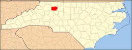 | |
| Townships | ||
| Unincorporated communities |
| |
