Wilson County, North Carolina
| Wilson County, North Carolina | ||
|---|---|---|
| County | ||
| County of Wilson | ||
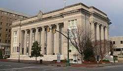 Wilson County Courthouse | ||
| ||
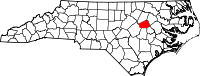 Location in the U.S. state of North Carolina | ||
 North Carolina's location in the U.S. | ||
| Founded | February 13, 1855 | |
| Named for | Col. Louis D. Wilson | |
| Seat | Wilson | |
| Largest city | Wilson | |
| Area | ||
| • Total | 374 sq mi (969 km2) | |
| • Land | 368 sq mi (953 km2) | |
| • Water | 5.6 sq mi (15 km2), 1.5% | |
| Population | ||
| • (2010) | 81,234 | |
| • Density | 221/sq mi (85/km2) | |
| ZIP Code(s) | 27542, 27557, 27803, 27807, 27813, 27822, 27829, 27830, 27851, 27852, 27873, 27878, 27880, 27883, 27888, 27893, 27896 | |
| Area code(s) | 252 | |
| Congressional districts | 1st, 2nd | |
| Time zone | Eastern: UTC−5/−4 | |
| Website |
www | |

Wilson County is a county located in the U.S. state of North Carolina. As of the 2010 Census, the population was 81,234.[1] The county seat is Wilson.[2] The county comprises the Wilson Micropolitan Statistical Area, which is also included within the Rocky Mount–Wilson–Roanoke Rapids Combined Statistical Area.
History
On February 13, 1855, the North Carolina General Assembly established Wilson County "out of portions of Edgecombe, Johnston, Nash, and Wayne counties."[3] The county was named for Colonel Louis D. Wilson, U.S. Volunteers, who died of fever while on leave from the State senate during the Mexican–American War.[4]
Geography
According to the U.S. Census Bureau, the county has a total area of 374 square miles (970 km2), of which 368 square miles (950 km2) is land and 5.6 square miles (15 km2) (1.5%) is water.[5]
Adjacent counties
- Nash County – north
- Edgecombe County – northeast
- Pitt County – east
- Greene County – southeast
- Wayne County – south
- Johnston County – southwest
Major highways
Demographics
| Historical population | |||
|---|---|---|---|
| Census | Pop. | %± | |
| 1860 | 9,720 | — | |
| 1870 | 12,258 | 26.1% | |
| 1880 | 16,064 | 31.0% | |
| 1890 | 18,644 | 16.1% | |
| 1900 | 23,596 | 26.6% | |
| 1910 | 28,269 | 19.8% | |
| 1920 | 36,813 | 30.2% | |
| 1930 | 44,914 | 22.0% | |
| 1940 | 50,219 | 11.8% | |
| 1950 | 54,506 | 8.5% | |
| 1960 | 57,716 | 5.9% | |
| 1970 | 57,486 | −0.4% | |
| 1980 | 63,132 | 9.8% | |
| 1990 | 66,061 | 4.6% | |
| 2000 | 73,814 | 11.7% | |
| 2010 | 81,234 | 10.1% | |
| Est. 2016 | 81,661 | [6] | 0.5% |
| U.S. Decennial Census[7] 1790-1960[8] 1900-1990[9] 1990-2000[10] 2010-2013[1] | |||
As of the census[11] of 2000, there 73,814 people, 28,613 households, and 19,771 families residing in the county. The population density was 199 people per square mile (77/km²). There were 30,729 housing units at an average density of 83 per square mile (32/km²). The racial makeup of the county was 55.83% White, 39.33% Black or African American, 0.27% Native American, 0.42% Asian, 0.02% Pacific Islander, 3.21% from other races, and 0.92% from two or more races. 6.04% of the population were Hispanic or Latino of any race.
There were 28,613 households out of which 31.90% had children under the age of 18 living with them, 48.10% were married couples living together, 16.50% had a female householder with no husband present, and 30.90% were non-families. 26.40% of all households were made up of individuals and 10.20% had someone living alone who was 65 years of age or older. The average household size was 2.51 and the average family size was 3.03.
In the county, the population was spread out with 25.60% under the age of 18, 9.10% from 18 to 24, 28.80% from 25 to 44, 23.60% from 45 to 64, and 12.90% who were 65 years of age or older. The median age was 36 years. For every 100 females there were 91.30 males. For every 100 females age 18 and over, there were 87.20 males.
The median income for a household in the county was $33,116, and the median income for a family was $41,551. Males had a median income of $30,364 versus $21,997 for females. The per capita income for the county was $17,102. About 13.80% of families and 18.50% of the population were below the poverty line, including 24.70% of those under age 18 and 21.30% of those age 65 or over.
Government
Wilson County Government is a member of the regional Upper Coastal Plain Council of Governments. It has several law enforcement agencies. Those agencies are as follows:
- Wilson County Sheriff's Office
- Wilson Police Department (City of Wilson)
- Stantonsburg Police Department (Town of Stantonsburg)
- Black Creek Police Department (Town of Black Creek)
- Sharpsburg Police Department (Town of Sharpsburg)
Politics
| Year | Republican | Democratic | Third parties |
|---|---|---|---|
| 2016 | 46.0% 17,531 | 51.6% 19,663 | 2.5% 941 |
| 2012 | 45.9% 17,954 | 53.4% 20,875 | 0.7% 280 |
| 2008 | 46.7% 17,375 | 52.8% 19,652 | 0.4% 164 |
| 2004 | 53.3% 16,264 | 46.5% 14,206 | 0.2% 65 |
| 2000 | 54.2% 13,466 | 45.4% 11,266 | 0.4% 94 |
| 1996 | 49.0% 10,518 | 45.6% 9,779 | 5.4% 1,154 |
| 1992 | 44.4% 10,176 | 44.1% 10,105 | 11.6% 2,656 |
| 1988 | 57.1% 10,997 | 42.7% 8,214 | 0.2% 46 |
| 1984 | 59.3% 12,243 | 40.4% 8,343 | 0.3% 57 |
| 1980 | 49.9% 8,329 | 48.1% 8,042 | 2.0% 333 |
| 1976 | 45.1% 6,795 | 54.4% 8,209 | 0.5% 80 |
| 1972 | 73.0% 12,060 | 25.2% 4,166 | 1.7% 286 |
| 1968 | 25.1% 4,053 | 25.9% 4,173 | 49.0% 7,903 |
| 1964 | 40.9% 5,002 | 59.1% 7,238 | |
| 1960 | 28.0% 3,114 | 72.0% 8,021 | |
| 1956 | 25.4% 2,830 | 74.6% 8,328 | |
| 1952 | 22.8% 2,569 | 77.2% 8,684 | |
| 1948 | 9.6% 665 | 86.3% 6,008 | 4.2% 293 |
| 1944 | 10.6% 769 | 89.4% 6,480 | |
| 1940 | 6.9% 584 | 93.1% 7,912 | |
| 1936 | 6.8% 549 | 93.2% 7,522 | |
| 1932 | 7.7% 517 | 91.6% 6,153 | 0.8% 51 |
| 1928 | 35.4% 1,933 | 64.7% 3,535 | |
| 1924 | 17.5% 574 | 80.0% 2,619 | 2.5% 81 |
| 1920 | 28.2% 1,374 | 71.8% 3,496 | |
| 1916 | 26.2% 730 | 73.8% 2,052 | |
| 1912 | 3.4% 82 | 73.0% 1,741 | 23.5% 561 |
Communities
City
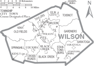
- Wilson (county seat)
Towns
- Black Creek
- Elm City
- Kenly (part)
- Lucama
- Saratoga
- Sims
- Stantonsburg
- Sharpsburg (part)
Unincorporated community
- Montclair
- Rock Ridge
Townships
- Black Creek
- Cross Roads
- Gardners
- Old Fields
- Saratoga
- Springhill
- Stantonsburg
- Taylors
- Toisnot
- Wilson
See also
References
- 1 2 "State & County QuickFacts". United States Census Bureau. Retrieved October 30, 2013.
- ↑ "Find a County". National Association of Counties. Retrieved 2011-06-07.
- ↑ Public Laws of the State of North-Carolina, Passed by the General Assembly, at its Session of 1854–'55: Together with the Comptroller's Statement of Public Revenue and Expenditure. Raleigh: Holden & Wilson. 1855. p. 30. LCCN 83644405 – via Internet Archive.
- ↑ Lichtenstein, Gaston (1911). Louis D. Wilson, Mexican War Martyr, also, Thos. H. Hall, Andrew Johnson as he Really was, and, Our Town Common; Four Articles. Richmond, Va.: H. T. Ezekiel. p. 7. OCLC 1127629. OL 14021029M – via Internet Archive.
- ↑ "2010 Census Gazetteer Files". United States Census Bureau. August 22, 2012. Archived from the original on January 12, 2015. Retrieved January 20, 2015.
- ↑ "Population and Housing Unit Estimates". Retrieved June 9, 2017.
- ↑ "U.S. Decennial Census". United States Census Bureau. Retrieved January 20, 2015.
- ↑ "Historical Census Browser". University of Virginia Library. Retrieved January 20, 2015.
- ↑ Forstall, Richard L., ed. (March 27, 1995). "Population of Counties by Decennial Census: 1900 to 1990". United States Census Bureau. Retrieved January 20, 2015.
- ↑ "Census 2000 PHC-T-4. Ranking Tables for Counties: 1990 and 2000" (PDF). United States Census Bureau. April 2, 2001. Retrieved January 20, 2015.
- ↑ "American FactFinder". United States Census Bureau. Retrieved 2008-01-31.
- ↑ Leip, David. "Dave Leip's Atlas of U.S. Presidential Elections". uselectionatlas.org. Retrieved 2018-03-17.
Further reading
- "Confederate Memorial Day" [Wilson County, North Carolina] (Black & white photoprint). Chapel Hill, N.C.: North Carolina Digital Heritage Center (DigitalNC). c. 1890. 5587. Retrieved December 20, 2016.
External links
- Official
- General information

- Wilson County Genealogical Society
Places adjacent to Wilson County, North Carolina | ||||||||||
|---|---|---|---|---|---|---|---|---|---|---|
| ||||||||||


| Authority control |
|---|