Pitt County, North Carolina
| Pitt County, North Carolina | ||
|---|---|---|
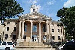 Pitt County Courthouse in Greenville | ||
| ||
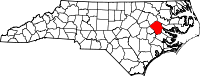 Location in the U.S. state of North Carolina | ||
 North Carolina's location in the U.S. | ||
| Founded | 1760 | |
| Named for | William Pitt the Elder | |
| Seat | Greenville | |
| Largest city | Greenville | |
| Area | ||
| • Total | 655 sq mi (1,696 km2) | |
| • Land | 652 sq mi (1,689 km2) | |
| • Water | 2.9 sq mi (8 km2), 0.4% | |
| Population (est.) | ||
| • (2013) | 174,263 | |
| • Density | 258/sq mi (100/km2) | |
| Congressional districts | 1st, 3rd | |
| Time zone | Eastern: UTC−5/−4 | |
| Website |
www | |

Pitt County is a county located in the U.S. state of North Carolina. As of the 2010 Census, the population was 168,148, making it the seventeenth-most populous county in North Carolina.[1] Its county seat is Greenville.[2]
Pitt County comprises the Greenville, NC Metropolitan Statistical Area. As one of the fastest growing centers in the state, the county has seen a population boom since 1990.
History
The county was formed in 1760 from Beaufort County, though the legislative act that created it did not become effective until January 1, 1761. It was named for William Pitt the Elder, who was then Secretary of State for the Southern Department and Leader of the House of Commons. William Pitt was an English statesman and orator, born in London, England. He studied at Oxford University and in 1731 joined the army. Pitt led the young "Patriot" Whigs and in 1756 became secretary of state, where he was a pro-freedom speaker in British Colonial government.
Geography
According to the U.S. Census Bureau, the county has a total area of 655 square miles (1,700 km2), of which 652 square miles (1,690 km2) is land and 2.9 square miles (7.5 km2) (0.4%) is water.[3]
Adjacent counties
- Martin County – northeast
- Beaufort County – east
- Craven County – south-southeast
- Lenoir County – south-southwest
- Greene County – southwest
- Wilson County – west
- Edgecombe County – northwest
Demographics
| Historical population | |||
|---|---|---|---|
| Census | Pop. | %± | |
| 1790 | 8,270 | — | |
| 1800 | 9,084 | 9.8% | |
| 1810 | 9,169 | 0.9% | |
| 1820 | 10,001 | 9.1% | |
| 1830 | 12,093 | 20.9% | |
| 1840 | 11,806 | −2.4% | |
| 1850 | 13,397 | 13.5% | |
| 1860 | 16,080 | 20.0% | |
| 1870 | 17,276 | 7.4% | |
| 1880 | 21,794 | 26.2% | |
| 1890 | 25,519 | 17.1% | |
| 1900 | 30,889 | 21.0% | |
| 1910 | 36,340 | 17.6% | |
| 1920 | 45,569 | 25.4% | |
| 1930 | 54,466 | 19.5% | |
| 1940 | 61,244 | 12.4% | |
| 1950 | 63,789 | 4.2% | |
| 1960 | 69,942 | 9.6% | |
| 1970 | 73,900 | 5.7% | |
| 1980 | 90,146 | 22.0% | |
| 1990 | 107,924 | 19.7% | |
| 2000 | 133,798 | 24.0% | |
| 2010 | 168,148 | 25.7% | |
| Est. 2016 | 177,220 | [4] | 5.4% |
| U.S. Decennial Census[5] 1790-1960[6] 1900-1990[7] 1990-2000[8] 2010-2013[1] | |||
As of the census[9] of 2000, there were 133,798 people, 52,539 households, and 32,258 families residing in the county. The population density was 205 people per square mile (79/km²). There were 58,408 housing units at an average density of 90 per square mile (35/km²). The racial makeup of the county was 62.08% White, 33.65% Black or African American, 0.27% Native American, 1.08% Asian, 0.04% Pacific Islander, 1.80% from other races, and 1.09% from two or more races. 3.15% of the population were Hispanic or Latino of any race.
There were 52,539 households out of which 29.90% had children under the age of 18 living with them, 43.40% were married couples living together, 14.40% had a female householder with no husband present, and 38.60% were non-families. 28.30% of all households were made up of individuals and 7.30% had someone living alone who was 65 years of age or older. The average household size was 2.43 and the average family size was 3.02.
In the county, the population was spread out with 23.60% under the age of 18, 17.50% from 18 to 24, 29.90% from 25 to 44, 19.40% from 45 to 64, and 9.60% who were 65 years of age or older. The median age was 30 years. For every 100 females there were 90.20 males. For every 100 females age 18 and over, there were 86.40 males.
The median income for a household in the county was $32,868, and the median income for a family was $43,971. Males had a median income of $31,962 versus $25,290 for females. The per capita income for the county was $18,243. About 13.50% of families and 20.30% of the population were below the poverty line, including 21.60% of those under age 18 and 20.20% of those age 65 or over.
As of the census of 2010, there were 168,148 people residing in Pitt County, a 25.7% increase since 2000. Females made up 52.8% of the population. Caucasians make up 58.9% of the population, followed by African-Americans at 34.1%, Asian persons at 1.6%, American Indian or Alaskan at 0.3%, Hispanic at 5.5%, and Native Hawaiian or Other Pacific Islander at 0.1%. From the period of 2005 to 2009, the number of foreign-born people living in the county was at 4%.
The high school graduation rate in the county among citizens over the age of twenty-five from 2005-2009 was steady at 85%, while the percentage of those aged twenty-five and up with a bachelor's degree in the county was only 28.7% in the county during the same period of time.
In 2009, the median household income in Pitt County was $36,339, over $7,000 less than the North Carolina number and about 25.5% of Pitt County residents were at or below the poverty level. The per capita money income, in terms of 2009 dollars, in the past twelve months from 2005-2009 in Pitt County was $21,622, about $3,000 less than the North Carolina average.
Communities

Cities
- Greenville (county seat)
Towns
Census-designated places
Unincorporated communities
Townships
- Arthur
- Ayden
- Belvoir
- Bethel
- Black Jack
- Carolina (Stokes)
- Chicod
- Falkland
- Farmville
- Fountain
- Greenville
- Grifton
- Grimesland
- Pactolus
- Simpson
- Swift Creek
- Winterville
Politics, law and government
In the early twentieth century Pitt was a typical Democratic "Solid South" county, where there were large numbers of disenfranchised blacks and the small white electorate voted overwhelming majorities for the Democratic Party. Pitt voted for the Democratic Party in every election from at least 1876 until American Independent candidate George Wallace gained a plurality in 1968. Apart from Richard Nixon's overwhelming victory over George McGovern in 1972, Pitt has since been a closely contested swing county, with no major party candidate post-McGovern falling under forty percent.
| Year | Republican | Democratic | Third parties |
|---|---|---|---|
| 2016 | 44.3% 35,691 | 51.9% 41,824 | 3.7% 3,012 |
| 2012 | 45.9% 36,214 | 53.1% 41,843 | 1.0% 799 |
| 2008 | 45.3% 33,927 | 54.1% 40,501 | 0.6% 456 |
| 2004 | 53.3% 28,590 | 46.5% 24,924 | 0.2% 129 |
| 2000 | 53.8% 23,192 | 45.7% 19,685 | 0.5% 198 |
| 1996 | 48.0% 18,227 | 46.2% 17,555 | 5.9% 2,229 |
| 1992 | 41.6% 16,609 | 45.0% 17,959 | 13.4% 5,327 |
| 1988 | 55.1% 18,245 | 44.6% 14,777 | 0.3% 105 |
| 1984 | 58.4% 18,983 | 41.5% 13,481 | 0.2% 62 |
| 1980 | 48.6% 12,816 | 47.7% 12,590 | 3.7% 965 |
| 1976 | 44.8% 9,532 | 54.7% 11,636 | 0.6% 120 |
| 1972 | 70.4% 14,406 | 28.6% 5,858 | 1.0% 195 |
| 1968 | 25.4% 5,745 | 34.0% 7,696 | 40.6% 9,167 |
| 1964 | 31.3% 5,149 | 68.7% 11,317 | |
| 1960 | 21.6% 3,458 | 78.4% 12,526 | |
| 1956 | 17.5% 2,515 | 82.5% 11,873 | |
| 1952 | 16.4% 2,203 | 83.7% 11,271 | |
| 1948 | 6.3% 602 | 89.5% 8,519 | 4.2% 401 |
| 1944 | 5.5% 495 | 94.5% 8,556 | |
| 1940 | 3.5% 369 | 96.5% 10,067 | |
| 1936 | 3.3% 325 | 96.7% 9,539 | |
| 1932 | 3.2% 255 | 96.6% 7,724 | 0.3% 21 |
| 1928 | 23.1% 1,395 | 76.9% 4,646 | |
| 1924 | 13.6% 512 | 84.9% 3,197 | 1.5% 56 |
| 1920 | 17.1% 864 | 82.9% 4,196 | |
| 1916 | 20.2% 719 | 79.8% 2,839 | |
| 1912 | 11.2% 347 | 74.6% 2,303 | 14.1% 436 |
Pitt County is a member of the Mid-East Commission regional council of governments.
Pitt County is represented by Dr. Greg Murphy, Jean Farmer-Butterfield and Susan Martin in the North Carolina House of Representatives and Donald G. Davis in the North Carolina Senate.
Education
Private
Private schools in Pitt County include:[11]
- Brookhaven SDA School
- Calvary Christian Academy
- Children's Montessori School
- Christ Covenant School
- Community Christian Academy
- Faith Christian Academy
- Greenville Christian Academy
- Greenville Montessori School
- John Paul II Catholic HS
- The Oakwood School
- Roseleaf Academy
- Saint Peter Catholic School
- Trinity Christian School
Public
Public schools in Pitt County are managed by the Pitt County School District.[12]
Elementary schools
- Ayden Elementary School
- Belvoir Elementary School
- Creekside Elementary School
- Eastern Elementary School
- Elmhurst Elementary School
- Falkland Elementary School
- H. B. Sugg School (K–2)
- Lake Forest Elementary School
- Northwest Elementary School
- Ridgewood Elementary School
- Sam D. Bundy School (3–5)
- South Greenville Elementary School
- W. H. Robinson Elementary School
- Wahl-Coates Elementary School
- Wintergreen Intermediate School (3–5)
- Wintergreen Primary School (K–2)
K–8 schools
- Bethel School
- Chicod School
- G. R. Whitfield School (Where the famous Kori Manning and Monica Cross attended school)
- Grifton School
- Pactolus School
- Stokes School
Middle schools
- A. G. Cox Middle School
- Ayden Middle School
- C. M. Eppes Middle School
- E. B. Aycock Middle School
- Farmville Middle School
- Hope Middle School
- Wellcome Middle School
High schools
- Ayden-Grifton High School
- D. H. Conley High School
- Farmville Central High School
- J. H. Rose High School
- North Pitt High School
- South Central High School
Alternative schools
- Pitt County Schools Early College High School
Post-secondary schools
Transportation
Major highways
Airport
American Airlines (PSA Airlines) serves the Pitt-Greenville Airport daily with connecting flights to Charlotte Douglas International Airport.
See also
References
- 1 2 "State & County QuickFacts". United States Census Bureau. Archived from the original on July 16, 2011. Retrieved October 29, 2013.
- ↑ "Find a County". National Association of Counties. Archived from the original on May 31, 2011. Retrieved 2011-06-07.
- ↑ "2010 Census Gazetteer Files". United States Census Bureau. August 22, 2012. Archived from the original on January 12, 2015. Retrieved January 18, 2015.
- ↑ "Population and Housing Unit Estimates". Retrieved June 9, 2017.
- ↑ "U.S. Decennial Census". United States Census Bureau. Archived from the original on May 12, 2015. Retrieved January 18, 2015.
- ↑ "Historical Census Browser". University of Virginia Library. Retrieved January 18, 2015.
- ↑ Forstall, Richard L., ed. (March 27, 1995). "Population of Counties by Decennial Census: 1900 to 1990". United States Census Bureau. Retrieved January 18, 2015.
- ↑ "Census 2000 PHC-T-4. Ranking Tables for Counties: 1990 and 2000" (PDF). United States Census Bureau. April 2, 2001. Retrieved January 18, 2015.
- ↑ "American FactFinder". United States Census Bureau. Retrieved 2008-01-31.
- ↑ Leip, David. "Dave Leip's Atlas of U.S. Presidential Elections". uselectionatlas.org. Retrieved 2018-03-17.
- ↑ "Private Schools". Greenville-Pitt Chamber of Commerce. Retrieved 12 December 2016.
- ↑ "Pitt County Schools". Retrieved 12 December 2016.
Further reading
- Kahrl, Andrew W., "The 'Negro Park' Question: Land, Labor, and Leisure in Pitt County, North Carolina, 1920–1930," Journal of Southern History (Feb. 2013) 79#1 pp 113–42.
External links
- Official website
- Pitt County Development Commission Website

- NCGenWeb Pitt County - free genealogy resources for the county
Places adjacent to Pitt County, North Carolina | ||||||||||
|---|---|---|---|---|---|---|---|---|---|---|
| ||||||||||
Municipalities and communities of Pitt County, North Carolina, United States | ||
|---|---|---|
| City | 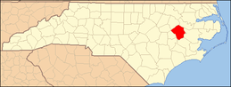 | |
| Towns | ||
| Townships |
| |
| CDPs | ||
| Unincorporated communities | ||
| Footnotes | ‡This populated place also has portions in an adjacent county or counties | |
