Tyrrell County, North Carolina
| Tyrrell County, North Carolina | ||
|---|---|---|
 The Tyrrell County Courthouse in Columbia | ||
| ||
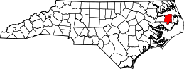 Location in the U.S. state of North Carolina | ||
 North Carolina's location in the U.S. | ||
| Founded | 1739 | |
| Named for | Sir John Tyrrell | |
| Seat | Columbia | |
| Largest town | Columbia | |
| Area | ||
| • Total | 594 sq mi (1,538 km2) | |
| • Land | 389 sq mi (1,008 km2) | |
| • Water | 205 sq mi (531 km2), 35% | |
| Population | ||
| • (2010) | 4,407 | |
| • Density | 11/sq mi (4/km2) | |
| Congressional district | 3rd | |
| Time zone | Eastern: UTC−5/−4 | |
| Website |
tyrrellcounty | |

Tyrrell County is a county located in the U.S. state of North Carolina. As of the 2010 Census, the population was 4,407[1] making it the least populous county in North Carolina. Its county seat is Columbia.[2] The county was created in 1729 as Tyrrell Precinct and gained county status in 1739.[3]
Tyrrell County is included in the Kill Devil Hills, NC Micropolitan Statistical Area, which is also included in the Virginia Beach-Norfolk, VA-NC Combined Statistical Area.
History
The county was formed in 1729 as Tyrrell Precinct of Albemarle County, from parts of Bertie Precinct, Chowan Precinct, Currituck Precinct, and Pasquotank Precinct. It was named for Sir John Tyrrell, one of the Lords Proprietors of Carolina.
With the abolition of Albemarle County in 1739, all of its constituent precincts became counties. In 1774 the western part of Tyrrell County was combined with part of Halifax County to form Martin County. In 1799 the western third of what was left of Tyrrell County became Washington County. In 1870 the half of Tyrrell County east of the Alligator River was combined with parts of Currituck County and Hyde County to form Dare County.
Geography
According to the U.S. Census Bureau, the county has a total area of 594 square miles (1,540 km2), of which 389 square miles (1,010 km2) is land and 205 square miles (530 km2) (35%) is water.[4]
Adjacent counties
- Washington County - west
- Dare County - east
- Hyde County - south
National protected area
Major highways
Demographics
| Historical population | |||
|---|---|---|---|
| Census | Pop. | %± | |
| 1790 | 4,826 | — | |
| 1800 | 3,395 | −29.7% | |
| 1810 | 3,364 | −0.9% | |
| 1820 | 4,319 | 28.4% | |
| 1830 | 4,732 | 9.6% | |
| 1840 | 4,657 | −1.6% | |
| 1850 | 5,133 | 10.2% | |
| 1860 | 4,944 | −3.7% | |
| 1870 | 4,173 | −15.6% | |
| 1880 | 4,545 | 8.9% | |
| 1890 | 4,225 | −7.0% | |
| 1900 | 4,980 | 17.9% | |
| 1910 | 5,219 | 4.8% | |
| 1920 | 4,849 | −7.1% | |
| 1930 | 5,164 | 6.5% | |
| 1940 | 5,556 | 7.6% | |
| 1950 | 5,048 | −9.1% | |
| 1960 | 4,520 | −10.5% | |
| 1970 | 3,806 | −15.8% | |
| 1980 | 3,975 | 4.4% | |
| 1990 | 3,856 | −3.0% | |
| 2000 | 4,149 | 7.6% | |
| 2010 | 4,407 | 6.2% | |
| Est. 2016 | 4,141 | [5] | −6.0% |
| U.S. Decennial Census[6] 1790-1960[7] 1900-1990[8] 1990-2000[9] 2010-2013[1] | |||
As of the census[10] of 2000, there were 4,149 people, 1,537 households, and 1,055 families residing in the county. However, the North Carolina Department of Commerce 2015 County Economic Development Tier Rankings place the current population at 3,653. The population density was 11 people per square mile (4/km²). There were 2,032 housing units at an average density of 5 per square mile (2/km²). The racial makeup of the county was 56.47% White, 39.43% African American, 0.19% Native American, 0.75% Asian, 2.05% from other races, and 1.11% from two or more races. Hispanic or Latino of any race were 3.62% of the population.
There were 1,537 households, of which 28.60% had children under the age of 18 living with them, 47.40% were married couples living together, 16.60% had a female householder with no husband present, and 31.30% were non-families. 28.20% of all households were made up of individuals and 14.40% had someone living alone who was 65 years of age or older. The average household size was 2.42 and the average family size was 2.95.
In the county, the population was spread out with 22.70% under the age of 18, 8.20% from 18 to 24, 30.30% from 25 to 44, 22.70% from 45 to 64, and 16.10% who were 65 years of age or older. The median age was 39 years. For every 100 females there were 114.10 males. For every 100 females age 18 and over, there were 114.20 males.
The median income for a household in the county was $25,684, and the median income for a family was $32,468. Males had a median income of $26,227 versus $18,403 for females. The per capita income for the county was $13,326. About 19.10% of families and 23.30% of the population were below the poverty line, including 31.50% of those under age 18 and 20.80% of those age 65 or over.
Law and government
Tyrrell County is a member of the Albemarle Commission regional council of governments.
Tyrrell County is governed by a 5-member Board of County Commissioners. The elections for County Commissioners are partisan and at large. In 2013, the County became the last county in North Carolina to adopt the County Manager form of government.
Tyrell County is represented by Bob Steinberg in the North Carolina House of Representatives.
Politics
| Year | Republican | Democratic | Third parties |
|---|---|---|---|
| 2016 | 56.1% 975 | 41.4% 720 | 2.5% 44 |
| 2012 | 52.2% 930 | 46.9% 837 | 0.9% 16 |
| 2008 | 50.3% 960 | 48.9% 933 | 0.9% 17 |
| 2004 | 53.8% 855 | 46.0% 731 | 0.3% 4 |
| 2000 | 45.1% 706 | 54.2% 849 | 0.7% 11 |
| 1996 | 32.3% 488 | 60.0% 908 | 7.7% 117 |
| 1992 | 33.0% 553 | 55.4% 928 | 11.5% 193 |
| 1988 | 44.7% 637 | 55.1% 785 | 0.2% 3 |
| 1984 | 48.9% 774 | 51.0% 807 | 0.1% 2 |
| 1980 | 34.0% 466 | 64.7% 887 | 1.2% 17 |
| 1976 | 30.9% 403 | 69.0% 900 | 0.2% 2 |
| 1972 | 59.3% 676 | 40.3% 459 | 0.4% 5 |
| 1968 | 22.6% 291 | 45.1% 581 | 32.3% 415 |
| 1964 | 27.3% 374 | 72.7% 996 | |
| 1960 | 27.4% 349 | 72.6% 926 | |
| 1956 | 40.6% 420 | 59.4% 615 | |
| 1952 | 29.6% 385 | 70.4% 916 | |
| 1948 | 30.2% 336 | 65.8% 732 | 4.0% 45 |
| 1944 | 31.5% 281 | 68.5% 611 | |
| 1940 | 26.7% 415 | 73.3% 1,140 | |
| 1936 | 22.5% 304 | 77.5% 1,049 | |
| 1932 | 22.7% 258 | 76.8% 873 | 0.5% 6 |
| 1928 | 51.5% 505 | 48.5% 475 | |
| 1924 | 40.9% 442 | 59.0% 638 | 0.1% 1 |
| 1920 | 42.6% 532 | 57.4% 718 | |
| 1916 | 48.5% 392 | 51.5% 416 | |
| 1912 | 35.8% 224 | 47.5% 297 | 16.6% 104 |
Economy
Tyrrell Count, due to its close proximity to the Outer Banks, has been designated as part of the IBX -Inner Banks.
NCSU Tyrrell County Center gives the county's residents easy access to the resources and expertise of NC State University and NC A&T State University.
The community is serviced by the Inner Banks Hotline, a non-profit women's community shelter.
Communities
Town
- Columbia (county seat)
Unincorporated communities
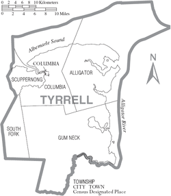
Townships
- Alligator
- Columbia
- Gum Neck
- Scuppernong
- South Fork
See also
References
- 1 2 "State & County QuickFacts". United States Census Bureau. Retrieved October 30, 2013.
- ↑ "Find a County". National Association of Counties. Retrieved 2011-06-07.
- ↑ "North Carolina: Individual County Chronologies". North Carolina Atlas of Historical County Boundaries. The Newberry Library. 2009. Retrieved January 25, 2015.
- ↑ "2010 Census Gazetteer Files". United States Census Bureau. August 22, 2012. Archived from the original on January 12, 2015. Retrieved January 20, 2015.
- ↑ "Population and Housing Unit Estimates". Retrieved June 9, 2017.
- ↑ "U.S. Decennial Census". United States Census Bureau. Retrieved January 20, 2015.
- ↑ "Historical Census Browser". University of Virginia Library. Retrieved January 20, 2015.
- ↑ Forstall, Richard L., ed. (March 27, 1995). "Population of Counties by Decennial Census: 1900 to 1990". United States Census Bureau. Retrieved January 20, 2015.
- ↑ "Census 2000 PHC-T-4. Ranking Tables for Counties: 1990 and 2000" (PDF). United States Census Bureau. April 2, 2001. Retrieved January 20, 2015.
- ↑ "American FactFinder". United States Census Bureau. Retrieved 2008-01-31.
- ↑ Leip, David. "Dave Leip's Atlas of U.S. Presidential Elections". uselectionatlas.org. Retrieved 2018-03-17.
External links
- NCGenWeb Tyrrell County - free genealogy resources for the county
Places adjacent to Tyrrell County, North Carolina | ||||||||||
|---|---|---|---|---|---|---|---|---|---|---|
| ||||||||||
Municipalities and communities of Tyrrell County, North Carolina, United States | ||
|---|---|---|
| Town | 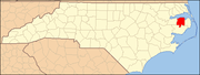 | |
| Unincorporated communities | ||
