Caldwell County, North Carolina
| Caldwell County, North Carolina | ||
|---|---|---|
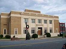 Caldwell County Courthouse in Lenoir | ||
| ||
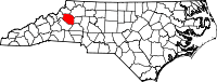 Location in the U.S. state of North Carolina | ||
 North Carolina's location in the U.S. | ||
| Founded | 1841 | |
| Named for |
Joseph Caldwell & Noah Galloway seat wl = Lenoir | |
| Largest city | Lenoir | |
| Area | ||
| • Total | 474 sq mi (1,228 km2) | |
| • Land | 472 sq mi (1,222 km2) | |
| • Water | 2.7 sq mi (7 km2), 0.6% | |
| Population | ||
| • (2010) | 83,029 | |
| • Density | 176/sq mi (68/km2) | |
| Congressional district | 11th | |
| Time zone | Eastern: UTC−5/−4 | |
| Website |
www | |

Caldwell County is a county located in the U.S. state of North Carolina in the foothills of the Appalachian Mountains. As of the 2010 census, the population was 83,029.[1] Its county seat is Lenoir.[2]
Caldwell County is part of the Hickory–Lenoir–Morganton, NC Metropolitan Statistical Area.
History
The county was formed in 1841 from parts of Burke County and Wilkes County. It was named for Joseph Caldwell, presiding professor (1796–1797, 1799–1804) and the first president (1804–1812, 1816–1835) of the University of North Carolina.
A series of reductions in the county's territory followed. In 1847 parts of Caldwell County, Iredell County, and Wilkes County were combined to form Alexander County. In 1849 parts of Caldwell County, Ashe County, Wilkes County, and Yancey County were combined to form Watauga County. In 1861, parts of Caldwell County, Burke County, McDowell County, Watauga County, and Yancey County were combined to form Mitchell County. Finally, in 1911 parts of Caldwell County, Mitchell County, and Watauga County were combined to form Avery County.
Geography
According to the U.S. Census Bureau, the county has a total area of 474 square miles (1,230 km2), of which 472 square miles (1,220 km2) is land and 2.7 square miles (7.0 km2) (0.6%) is water.[3]
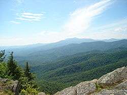
Caldwell County is divided into three distinct geographic sections: the Blue Ridge Mountains, which dominate the northern and western parts of the county; the gently rolling Piedmont country in the middle and southern parts of the county; and the Brushy Mountains, an isolated remnant of the Blue Ridge Mountains. The "Brushies", as they are often called, run across much of Caldwell County's eastern section. Hibriten Mountain, located within the city limits of Lenoir, the county's largest city, marks the western end of the Brushy Mountain range. In the western part of the county is the Wilson Creek area.
National protected areas
- Blue Ridge Parkway (part)
- Pisgah National Forest (part)
Demographics
| Historical population | |||
|---|---|---|---|
| Census | Pop. | %± | |
| 1850 | 6,317 | — | |
| 1860 | 7,497 | 18.7% | |
| 1870 | 8,476 | 13.1% | |
| 1880 | 10,291 | 21.4% | |
| 1890 | 12,298 | 19.5% | |
| 1900 | 15,694 | 27.6% | |
| 1910 | 20,579 | 31.1% | |
| 1920 | 19,984 | −2.9% | |
| 1930 | 28,016 | 40.2% | |
| 1940 | 35,795 | 27.8% | |
| 1950 | 43,352 | 21.1% | |
| 1960 | 49,552 | 14.3% | |
| 1970 | 56,699 | 14.4% | |
| 1980 | 67,746 | 19.5% | |
| 1990 | 70,709 | 4.4% | |
| 2000 | 77,415 | 9.5% | |
| 2010 | 83,029 | 7.3% | |
| Est. 2016 | 81,449 | [4] | −1.9% |
| U.S. Decennial Census[5] 1790-1960[6] 1900-1990[7] 1990-2000[8] 2010-2014[1] | |||
As of the census of 2010,[9] there were 83,029 people, 33,388 households, and 23,456 families residing in the county. The population density was 176.1 people per square mile (109.4/km²). There were 37,659 housing units at an average density of 79.9 per square mile (49.6/km²). The racial makeup of the county was 90.24% White, 4.92% Black or African American, 0.52% Asian, 0.31% Native American, 0.03% Pacific Islander, 2.47% from other races, and 1.51% from two or more races. The Hispanic or Latino (of any race) population was 4.57%.
There were 33,388 households of which 32.40% had children under the age of 18 living with them, 52.16% were married couples living together, 12.52% had a female householder with no husband present, and 29.75% were non-families. 25.39% of all households were made up of individuals living alone and 41.16% of those households had someone living alone who was 65 years of age or older. The average household size was 2.46 and the average family size was 2.91.
Of the county's entire population, 22.63% was under the age of 18, 18.33% were 18 to 34, 22.44% were 35 to 49, 21.17% were 50 to 64, and 15.44% were 65 years of age or older. The median age was 41.3 years. For every 100 females there were 96.84 males. For every 100 females age 18 and over, there were 95.06 males.
The median income for a household in the county was $34,853, and the median income for a family was $47,028. Males had a median income of $36,429 versus $31,221 for females. The per capita income for the county was $19,397. About 15.3% of families and 20.50% of the population were below the poverty line, including 51.8% of single mothers and 13.2% of people age 65 or over.
Law and government
The county is governed by a five-member Board of Commissioners. They are elected by popular vote and appoint a County Manager to handle daily operations, currently Stan Kiser.[10][11] The members of the Board of Commissioners are Jeff Branch, Randy Church, Mike LaBrose, Donnie Potter, and Robbie Wilkie.[12] Caldwell County's sheriff is Alan C. Jones.[13] The Clerk of Superior Court is Kim Clark.[14] The County's Register of Deeds is Wayne Rash.[15] Caldwell County is a member of the regional Western Piedmont Council of Governments.[16]
In the North Carolina General Assembly, the county is represented by Republican Deanna Ballard in the North Carolina Senate, as part of N.C. Senate District 45, and by Republican Destin Hall in the North Carolina House of Representatives, as N.C. House District 87.[17][18] Due to North Carolina's court-ordered redistricting, Caldwell County will move to N.C. Senate District 46 in 2019, where it will be represented by either Republican incumbent Warren Daniel or Democratic challenger Art Sherwood.[19][20]
Caldwell County is part of North Carolina's 11th congressional district, represented by Republican Mark Meadows in the United States House of Representatives.[21]
| Year | Republican | Democratic | Third parties |
|---|---|---|---|
| 2016 | 73.3% 26,621 | 23.2% 8,425 | 3.5% 1,274 |
| 2012 | 66.9% 23,229 | 31.4% 10,898 | 1.7% 605 |
| 2008 | 64.1% 22,526 | 34.4% 12,081 | 1.6% 548 |
| 2004 | 67.6% 21,186 | 31.9% 9,999 | 0.5% 163 |
| 2000 | 66.4% 17,337 | 32.9% 8,588 | 0.7% 190 |
| 1996 | 55.2% 12,653 | 35.1% 8,050 | 9.7% 2,228 |
| 1992 | 49.0% 12,543 | 35.3% 9,033 | 15.6% 4,000 |
| 1988 | 65.8% 15,176 | 34.1% 7,862 | 0.1% 33 |
| 1984 | 69.8% 17,024 | 30.0% 7,311 | 0.2% 59 |
| 1980 | 58.1% 12,965 | 39.2% 8,738 | 2.7% 607 |
| 1976 | 45.2% 9,872 | 54.4% 11,894 | 0.5% 100 |
| 1972 | 71.4% 12,976 | 26.9% 4,886 | 1.7% 309 |
| 1968 | 51.5% 10,433 | 23.4% 4,746 | 25.1% 5,095 |
| 1964 | 44.6% 8,733 | 55.4% 10,846 | |
| 1960 | 57.0% 11,553 | 43.0% 8,722 | |
| 1956 | 61.2% 10,833 | 38.8% 6,861 | |
| 1952 | 54.9% 9,160 | 45.1% 7,533 | |
| 1948 | 46.2% 4,987 | 46.7% 5,033 | 7.1% 765 |
| 1944 | 44.6% 4,365 | 55.4% 5,419 | |
| 1940 | 32.2% 3,005 | 67.8% 6,334 | |
| 1936 | 33.4% 3,421 | 66.6% 6,809 | |
| 1932 | 40.4% 3,750 | 59.1% 5,479 | 0.5% 46 |
| 1928 | 64.7% 4,207 | 35.3% 2,291 | |
| 1924 | 42.6% 2,503 | 57.0% 3,348 | 0.4% 26 |
| 1920 | 53.0% 3,298 | 47.1% 2,931 | |
| 1916 | 49.0% 1,659 | 51.0% 1,725 | |
| 1912 | 14.7% 482 | 49.5% 1,627 | 35.8% 1,178 |
Education
Elementary Schools
- Baton
- Davenport
- Dudley Shoals
- Gamewell
- Granite Falls
- Hudson
- Lower Creek
- Sawmills
- Valmead
- West Lenoir
- Whitnel
K-8 Schools
- Collettsville
- Happy Valley
- Kings Creek
- Oak Hill
Middle Schools
- Gamewell
- Granite Falls
- Hudson
- William Lenoir
High Schools
- Caldwell Early College
- Career Center Middle College
- Hibriten
- South Caldwell
- West Caldwel
Alternative Schools
- Horizons Elementary
- Gateway School
College
- Caldwell Community College & Technical Institute[23]
- Appalachian State University Center at Caldwell (a distance education site for Appalachian State University)[24]
Transportation
Major highways
![]()
Other major highways include:
The Blue Ridge Parkway also crosses the northern tip of the county.
Railroads
Caldwell County has one railroad, the Caldwell County Railroad which interchanges with the Norfolk Southern Railway in Hickory, North Carolina.[26]
Communities
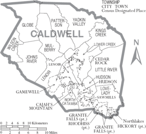
Cities
Towns
Village
Census-designated place
Other unincorporated communities
Notable people
- Johnny Allen, former MLB player
- Claude Baker, composer
- Etta Baker, musician
- William Horton Bower, US congressman
- Jim Broyhill, US congressman and senator
- Madison Bumgarner, MLB player, also was 2014 World Series MVP
- Claudia Church, country music artist
- Eric Church, country music artist
- Clinton A. Cilley, mayor of Lenoir and Medal of Honor recipient
- Dr. Linda Combs, U.S. government official
- Charlie Cozart, former MLB player
- Jack Curtis, former MLB player
- Lindsay Deal, former MLB player
- Nick Easton, offensive lineman in the NFL
- Wallis Hutchens, former MLB player
- William Lenoir, soldier and statesman
- Bob McCreary, former NFL player
- Kary Mullis, scientist and Nobel laureate
- William C. Newland, North Carolina lieutenant governor
- James Pritchett, actor
- Larry Smith, NASCAR driver
- Vaughn E. Starnes, surgeon who performed life saving operation on Jimmy Kimmel's son[27][28]
- Rube Walker, former MLB player
- Maxie Williams, former NFL player
- George Younce, gospel singer
See also
References
- 1 2 "State & County QuickFacts". United States Census Bureau. Retrieved October 18, 2013.
- ↑ "Find a County". National Association of Counties. Archived from the original on 2011-05-31. Retrieved 2011-06-07.
- ↑ "2010 Census Gazetteer Files". United States Census Bureau. August 22, 2012. Archived from the original on January 12, 2015. Retrieved January 12, 2015.
- ↑ "Population and Housing Unit Estimates". Retrieved June 9, 2017.
- ↑ "U.S. Decennial Census". United States Census Bureau. Archived from the original on May 12, 2015. Retrieved January 12, 2015.
- ↑ "Historical Census Browser". University of Virginia Library. Retrieved January 12, 2015.
- ↑ Forstall, Richard L., ed. (March 27, 1995). "Population of Counties by Decennial Census: 1900 to 1990". United States Census Bureau. Retrieved January 12, 2015.
- ↑ "Census 2000 PHC-T-4. Ranking Tables for Counties: 1990 and 2000" (PDF). United States Census Bureau. April 2, 2001. Retrieved January 12, 2015.
- ↑ "Caldwell County North Carolina Quickfacts". United States Census Bureau. Retrieved 7 May 2016.
- ↑ "NC SBE Contest Results". er.ncsbe.gov. Retrieved 2018-07-07.
- ↑ "Administration". Retrieved 29 March 2018.
- ↑ "Commissioners". Caldwell County Government. Retrieved 29 March 2018.
- ↑ "Sheriff's Office". Caldwell County Government. Retrieved 20 March 2016.
- ↑ "Kim Clark, Clerk of Superior Court". Caldwell Chamber of Commerce. Retrieved 30 March 2018.
- ↑ "About Your Register". Caldwell County Register of Deeds. Retrieved 30 March 2018.
- ↑ "WPCOG". Western Piedmont Council of Governments. Retrieved 30 March 2018.
- ↑ "Senator Deanna Ballard (Republican, 2017-2018 Session)". North Carolina General Assembly. Retrieved 30 March 2018.
- ↑ "Representative Destin Hall (Republican, 2017-2018 Session)". North Carolina General Assembly. Retrieved 30 March 2018.
- ↑ "Did NC redistricting affect your ballot? Find out here". WRAL. Capitol Broadcasting Company, Inc. Retrieved 1 June 2018.
- ↑ "2018 State Filing List (CSV)". NCSBE.gov. North Carolina State Board of Elections & Ethics Enforcement. Retrieved 1 June 2018.
- ↑ "Congressman Mark Meadows". United States House of Representatives. Retrieved 20 March 2016.
- ↑ Leip, David. "Dave Leip's Atlas of U.S. Presidential Elections". uselectionatlas.org. Retrieved 2018-03-14.
- ↑ "Caldwell County Schools - School Directory". Caldwell County Schools. Retrieved 20 March 2016.
- ↑ "ASU Center at Caldwell (located on the Hudson Campus of Caldwell Community College and Tech Institute)". Appalachian State University. Retrieved 7 May 2016.
- ↑ "2014 AADT PDF Report" (PDF). North Carolina Department of Transportation. Retrieved 7 May 2016.
- ↑ Infrastructure, Caldwell County Economic Development Commission (retrieved 16 June 2014)
- ↑ Caldwell County Schools. (n.d.) Retrieved July 23, 2018, from https://www.caldwellschools.com/Page/570
- ↑ Bennett, Abbie (May 8, 2017). Surgeon who performed life-saving operation on Jimmy Kimmel's son graduated from UNC. Retrieved July 23, 2018, from https://www.newsobserver.com/news/business/health-care/article149145164.html
External links
- Caldwell County Economic Development Commission
- Caldwell County government official website

Places adjacent to Caldwell County, North Carolina | ||||||||||
|---|---|---|---|---|---|---|---|---|---|---|
| ||||||||||
Municipalities and communities of Caldwell County, North Carolina, United States | ||
|---|---|---|
| Cities |  | |
| Towns | ||
| Village | ||
| CDP | ||
| Unincorporated communities | ||
| Footnotes | ‡This populated place also has portions in an adjacent county or counties | |
