Burke County, North Carolina
| Burke County, North Carolina | ||
|---|---|---|
.jpg) Burke County Courthouse | ||
| ||
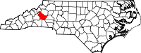 Location in the U.S. state of North Carolina | ||
 North Carolina's location in the U.S. | ||
| Founded | 1777 | |
| Named for | Thomas Burke | |
| Seat | Morganton | |
| Largest city | Morganton | |
| Area | ||
| • Total | 515 sq mi (1,334 km2) | |
| • Land | 507 sq mi (1,313 km2) | |
| • Water | 8.0 sq mi (21 km2), 1.5% | |
| Population | ||
| • (2010) | 90,912 | |
| • Density | 179/sq mi (69/km2) | |
| Congressional district | 11th | |
| Time zone | Eastern: UTC−5/−4 | |
| Website |
www | |

Burke County is a county located in the U.S. state of North Carolina. As of 2010 census, the population was 90,912.[1] Its county seat is Morganton.[2]
Burke County is part of the Hickory–Lenoir–Morganton, NC Metropolitan Statistical Area.
The first European settlement in the interior of North Carolina (and what would become the United States) was made by a Spanish expedition in 1567, when they built Fort San Juan at the large Mississippian culture Native American chiefdom of Joara. Present-day Morganton later developed at this site. The Spanish renamed the settlement Cuenca.[3] The following year the Indians killed nearly all the Spanish garrisoned at this and five other interior forts, and burned Fort San Juan. It was two centuries before Europeans tried to settle again this far west in the colony.
History
Indigenous peoples inhabited the interior as well as the coastal areas for thousands of years. Native Americans of the Mississippian culture inhabited the county long before Europeans arrived in the New World. The largest Mound Builder settlement was at Joara, a 12-acre (49,000 m2) site and regional chiefdom near present-day Morganton. It was the center of the largest Native American settlement in North Carolina, dating from about 1000 AD and expanding into the next centuries.[3]
In 1567, a Spanish expedition arrived and built Fort San Juan, claiming the area for the colony of Spanish Florida. They had been sent by the governor at Santa Elena (Parris Island) in South Carolina. Captain Juan Pardo, leader of the expedition, left about 30 soldiers at the fort while continuing his exploration. In the spring of 1568 the Indians attacked the fort, killing the soldiers and burning the fort. Indians killed the garrisons at five other Spanish forts in the interior. Introduction of European diseases caused high fatalities among the Mississippians, and takeover of survivors by larger tribes led to Native American abandonment of the area. Two hundred years passed before the next Europeans: English, Scots-Irish and German colonists, attempted to settle here again.[3]
In 1777, Burke County was formed from Rowan County. It was named for Thomas Burke, then serving as a delegate to the Continental Congress (1777 to 1781). He was later elected as Governor of North Carolina, serving from 1781 to 1782. The western Piedmont was settled by many Scots-Irish and German immigrants in the mid-to-late 18th century. They were generally yeoman farmers and fiercely independent.
As population increased, the county was divided to form other jurisdictions. In 1791, parts of Burke County and Rutherford County were combined to form Buncombe County. In 1833, parts of Burke and Buncombe counties were combined to form Yancey County. In 1841, parts of Burke and Wilkes counties were combined to form Caldwell County. In 1842 additional parts of Burke and Rutherford counties were combined to form McDowell County. Finally, in 1861, parts of Burke, Caldwell, McDowell, Watauga, and Yancey counties were combined to form Mitchell County.
Burke County citizens participated in the Battle of Kings Mountain, which pitted Appalachian frontiersmen against the Loyalist forces of the British commander Ferguson at Kings Mountain, SC in the American Revolution. Rather than waiting for Ferguson to invade their territory, militiamen throughout the Blue Ridge crossed over the mountains and thus were called the "Over Mountain Men". (Clark, "Burke County," pp. 37–39)
Geography
According to the U.S. Census Bureau, the county has a total area of 515 square miles (1,330 km2), of which 507 square miles (1,310 km2) is land and 8.0 square miles (21 km2) (1.5%) is water.[4] The county contains portions of two lakes: Lake James along its western border with McDowell County and Lake Rhodhiss along its northeastern border with Caldwell County.
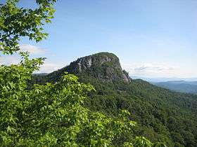
Table Rock, a prominent peak in the county in the east rim of Linville Gorge, part of Pisgah National Forest, has been described as "the most visible symbol in the region".[5]
National protected areas
- Blue Ridge Parkway (part)
- Pisgah National Forest (part)
Major highways
Demographics
| Historical population | |||
|---|---|---|---|
| Census | Pop. | %± | |
| 1790 | 8,106 | — | |
| 1800 | 9,929 | 22.5% | |
| 1810 | 11,007 | 10.9% | |
| 1820 | 13,411 | 21.8% | |
| 1830 | 17,888 | 33.4% | |
| 1840 | 15,799 | −11.7% | |
| 1850 | 7,772 | −50.8% | |
| 1860 | 9,237 | 18.8% | |
| 1870 | 9,777 | 5.8% | |
| 1880 | 12,809 | 31.0% | |
| 1890 | 14,939 | 16.6% | |
| 1900 | 17,699 | 18.5% | |
| 1910 | 21,408 | 21.0% | |
| 1920 | 23,297 | 8.8% | |
| 1930 | 29,410 | 26.2% | |
| 1940 | 38,615 | 31.3% | |
| 1950 | 45,518 | 17.9% | |
| 1960 | 52,701 | 15.8% | |
| 1970 | 60,364 | 14.5% | |
| 1980 | 72,504 | 20.1% | |
| 1990 | 75,744 | 4.5% | |
| 2000 | 89,148 | 17.7% | |
| 2010 | 90,912 | 2.0% | |
| Est. 2016 | 88,851 | [6] | −2.3% |
| U.S. Decennial Census[7] 1790–1960[8] 1900–1990[9] 1990–2000[10] 2010–2014[1] | |||
As of the census[11] of 2000, there were 89,148 people, 34,528 households, and 24,342 families residing in the county. The population density was 176 people per square mile (68/km²). There were 37,427 housing units at an average density of 74 per square mile (29/km²). The racial makeup of the county was 86.01% White, 6.71% Black or African American, 0.30% Native American, 3.48% Asian, 0.21% Pacific Islander, 2.17% from other races, and 1.11% from two or more races. 3.57% of the population were Hispanic or Latino of any race.
There were 34,528 households out of which 31.00% had children under the age of 18 living with them, 54.90% were married couples living together, 11.00% had a female householder with no husband present, and 29.50% were non-families. 25.50% of all households were made up of individuals and 9.90% had someone living alone who was 65 years of age or older. The average household size was 2.48 and the average family size was 2.94.
In the county, the population was spread out with 24.00% under the age of 18, 8.90% from 18 to 24, 29.60% from 25 to 44, 24.00% from 45 to 64, and 13.40% who were 65 years of age or older. The median age was 37 years. For every 100 females there were 100.00 males. For every 100 females age 18 and over, there were 97.70 males.
The median income for a household in the county was $35,629, and the median income for a family was $42,114. Males had a median income of $27,591 versus $21,993 for females. The per capita income for the county was $17,397. About 8.00% of families and 10.70% of the population were below the poverty line, including 13.60% of those under age 18 and 12.50% of those age 65 or over.
Communities
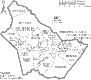
Cities
- Morganton (county seat)
Towns
Townships
- Drexel
- Icard
- Jonas Ridge
- Linville
- Lovelady
- Lower Creek
- Lower Fork
- Quaker Meadows
- Silver Creek
- Smoky Creek
- Upper Creek
- Upper Fork
- Hildebran
- Connelly Springs
- Rutherford College
- Valdese
Census-designated places
Unincorporated communities
Politics, law and government
Burke is a strongly Republican county in Presidential elections. The last Democrat to carry the county was Jimmy Carter in 1976, and Lyndon Johnson, twelve years previously, is the only other one to do so since World War II. As is typical for all of the South outside the Appalachian highlands, the county was solidly Democratic before WWII, but did go Republican in 1908 as well as in the landslides of 1920 and the anti-Catholic 1928 election.
| Year | Republican | Democratic | Third parties |
|---|---|---|---|
| 2016 | 67.4% 26,238 | 28.9% 11,251 | 3.7% 1,431 |
| 2012 | 60.9% 22,267 | 37.5% 13,701 | 1.6% 576 |
| 2008 | 59.0% 22,102 | 39.8% 14,901 | 1.2% 440 |
| 2004 | 61.5% 18,922 | 38.1% 11,728 | 0.4% 112 |
| 2000 | 60.2% 18,466 | 38.9% 11,924 | 0.9% 268 |
| 1996 | 49.0% 13,853 | 41.3% 11,678 | 9.8% 2,760 |
| 1992 | 44.5% 13,397 | 41.7% 12,565 | 13.8% 4,160 |
| 1988 | 59.4% 15,933 | 40.5% 10,848 | 0.1% 38 |
| 1984 | 64.3% 18,766 | 35.5% 10,353 | 0.2% 59 |
| 1980 | 51.0% 12,956 | 46.0% 11,680 | 3.1% 781 |
| 1976 | 41.2% 10,070 | 58.3% 14,254 | 0.4% 107 |
| 1972 | 69.0% 14,447 | 29.6% 6,197 | 1.5% 306 |
| 1968 | 48.8% 11,068 | 25.2% 5,704 | 26.0% 5,892 |
| 1964 | 44.0% 10,081 | 56.0% 12,815 | |
| 1960 | 56.3% 12,925 | 43.7% 10,015 | |
| 1956 | 59.7% 11,823 | 40.4% 7,999 | |
| 1952 | 59.0% 11,113 | 41.0% 7,732 | |
| 1948 | 47.3% 6,374 | 46.2% 6,226 | 6.6% 888 |
| 1944 | 46.3% 5,855 | 53.7% 6,795 | |
| 1940 | 40.3% 4,889 | 59.7% 7,242 | |
| 1936 | 42.5% 5,506 | 57.5% 7,454 | |
| 1932 | 44.9% 4,823 | 54.6% 5,866 | 0.4% 47 |
| 1928 | 63.9% 5,108 | 36.1% 2,881 | |
| 1924 | 43.5% 3,190 | 56.5% 4,137 | |
| 1920 | 52.4% 3,592 | 47.6% 3,262 | |
| 1916 | 47.6% 1,474 | 52.4% 1,621 | |
| 1912 | 1.8% 48 | 50.5% 1,365 | 47.7% 1,288 |
In the North Carolina Senate, Burke County lies within the 46th Senate District, which also covers Cleveland County and is represented by Republican Senator Warren Daniel. In the North Carolina House of Representatives, the northern two-thirds of Burke County comprises the 86th District represented by Republican Hugh Blackwell. The southern third lies within the 112nd District, which also covers Rutherford County and is represented by Republican David Rogers.
Burke County is a member of the regional Western Piedmont Council of Governments. The county is governed by a five-member Board of Commissioners, elected to serve four-year terms.[13]
Notable people
- William Waightstill Avery, (1816–1864), member of the Congress of the Confederate States from North Carolina[14]
- Isaac Avery, (1828-1863), Confederate officer killed at Gettysburg. Most remembered for the blood-stained note he wrote to his father while dying.
- Tod Caldwell (1818–1874) 41st Governor of North Carolina.
- Etta Baker, (1913–2006), Piedmont Blues guitarist and singer
- Sam Ervin, (1896–1985), U.S. Senator from 1954 to 1975; famed Chairman of the Senate Watergate Committee in 1973.
- Leon Johnson, (born 1974), footballer.
- Tom Scott (born 1970), NFL player
- Samuel David Dunavant, (1839–1906). Southern railroad contractor active 1860–1906: co-supervised construction of Western NC Railroad from Salisbury to Burke, and later to Asheville. (This was the first east-west rail line into Western NC.) Co-founded Burke's first cotton mill, Dunavant Cotton Mnfg. Co. (later owned and operated as the Alpine Cotton Mill by William Allen Erwin; and finally operated as Drexel Furniture). Also in Morganton, owned a brickyard and livery stable, and built the Eagle (Southern) Hotel.
- Burgess Sidney Gaither Sr., (1807–1892), NC Senate President Pro Tempore, Charlotte Mint Superintendent, Confederate States Congress Delegate
- Tyler Shatley , NFL player
- John William "Johnny" Bristol (February 3, 1939 – March 21, 2004)[1] was an American musician, most famous as a songwriter and record producer for the Motown label in the late 1960s and early 1970s. He was a native of Morganton, North Carolina, about which he wrote an eponymous song. His composition "Love Me for a Reason" saw global success when covered by The Osmonds including a number 1 in the UK charts in 1974.[1] His most famous solo recording was "Hang On in There Baby" recorded in 1974, which reached the Top Ten in the United States and number 3 in the United Kingdom.[2][3] Both singles were in the UK top 5 simultaneously. Co-wrote, "Someday We'll be together" made famous by Diana Ross and the Supremes in 1961.
In popular culture
Although never explicitly mentioned by name in the novel, the hideout of Robur-the villain in Jules Verne's Master of the World-is thought to be Table Rock mountain in Burke County.
Many scenes from the 1992 film Last of the Mohicans were filmed in Burke County. A full-scale fort was built next to the Linville boat access on Lake James for the filming. The fort was later destroyed and the land replanted with trees. Many of the extras who played settlers, British soldiers, and Native Americans were locals from Burke and surrounding counties.
The final scene from The Hunt for Red October had the backdrop filmed on Lake James, while the actors stayed in Hollywood
In 2011, scenes for the Lionsgate adaptation of The Hunger Games were filmed near Hildebran, North Carolina at the Henry River Mill Village.
See also
References
- 1 2 "State & County QuickFacts". United States Census Bureau. Retrieved October 17, 2013.
- ↑ "Find a County". National Association of Counties. Archived from the original on 31 May 2011. Retrieved 2011-06-07.
- 1 2 3 David Moore, Robin Beck, and Christopher Rodning, "In Search of Fort San Juan: Sixteenth Century Spanish and Native Interaction in the North Carolina Piedmont", Warren Wilson College Archaeology Home Page, 2004, accessed 26 June 2008
- ↑ "2010 Census Gazetteer Files". United States Census Bureau. August 22, 2012. Archived from the original on January 12, 2015. Retrieved January 12, 2015.
- ↑ Clark, Larry (2007). Burke County, North Carolina: Historic Tales from the Gateway to the Blue Ridge. The History Press. pp. 11–12. ISBN 1-59629-323-3.
- ↑ "Population and Housing Unit Estimates". Retrieved June 9, 2017.
- ↑ "U.S. Decennial Census". United States Census Bureau. Archived from the original on 12 May 2015. Retrieved January 12, 2015.
- ↑ "Historical Census Browser". University of Virginia Library. Retrieved January 12, 2015.
- ↑ Forstall, Richard L., ed. (March 27, 1995). "Population of Counties by Decennial Census: 1900 to 1990". United States Census Bureau. Retrieved January 12, 2015.
- ↑ "Census 2000 PHC-T-4. Ranking Tables for Counties: 1990 and 2000" (PDF). United States Census Bureau. April 2, 2001. Retrieved January 12, 2015.
- ↑ "American FactFinder". United States Census Bureau. Archived from the original on 11 September 2013. Retrieved 2008-01-31.
- ↑ Leip, David. "Dave Leip's Atlas of U.S. Presidential Elections". uselectionatlas.org. Retrieved 2018-03-14.
- ↑ Burke County Board of Commissioners
- ↑ Who Was Who in America, Historical Volume, 1607–1896. Chicago: Marquis Who's Who. 1963.
External links
![]()
Places adjacent to Burke County, North Carolina | ||||||||||
|---|---|---|---|---|---|---|---|---|---|---|
| ||||||||||
Municipalities and communities of Burke County, North Carolina, United States | ||
|---|---|---|
| Cities | 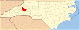 | |
| Towns | ||
| Townships |
| |
| CDPs | ||
| Unincorporated communities | ||
| Footnotes | ‡This populated place also has portions in an adjacent county or counties | |
