Henderson County, North Carolina
| Henderson County, North Carolina | |
|---|---|
| County | |
| Henderson County | |
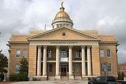
 The current Henderson County Courthouse | |
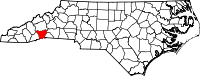 Location in the U.S. state of North Carolina | |
 North Carolina's location in the U.S. | |
| Founded | December 15, 1838 |
| Named for | Leonard Henderson |
| Seat | Hendersonville |
| Largest city | Hendersonville |
| Area | |
| • Total | 375 sq mi (971 km2) |
| • Land | 373 sq mi (966 km2) |
| • Water | 2.2 sq mi (6 km2), 0.6% |
| Population (est.) | |
| • (2013) | 109,540 |
| • Density | 286/sq mi (110/km2) |
| Congressional district | 11th |
| Time zone | Eastern: UTC−5/−4 |
| Website |
www |
Henderson County is a county located in the U.S. state of North Carolina. As of the 2010 census, the population was 106,740.[1] Its county seat is Hendersonville.[2]
Henderson County is part of the Asheville, NC Metropolitan Statistical Area.
History
The county was formed in 1838 from the southern part of Buncombe County. It was named for Leonard Henderson, Chief Justice of the North Carolina Supreme Court from 1829 to 1833.[3] There is no evidence Henderson ever passed through the area.[4]
In 1855 parts of Henderson County and Rutherford County were combined to form Polk County, and in 1861 parts of Henderson County and Jackson County were combined to form Transylvania County.
Henderson County, which in 1861 encompassed present-day Transylvania County as well, contributed 1,296 soldiers to the Confederate States Army out of its approximately 10,000 population, as well as 130 Union troops. (Figures from Terrell T. Garren's "Mountain Myth: Unionism in Western North Carolina, published 2006).
Henderson County government was centered around Hendersonville in the 1905 county courthouse on Main Street, until this structure was replaced by the new Courthouse (c. 1995) on Grove Street in Hendersonville.
The first rail line reached Hendersonville in 1879, ushering in a new era of access to the outside world. However, parts of the county had long been known as retreats, including the "Little Charleston" of Flat Rock in which South Carolina's Low Country planter families had maintained second homes since the early 19th century.
A major land boom ensued in the 1920s, culminating in the crash of 1929, which severely deflated prices and left structures such as the Fleetwood Hotel atop Jumpoff Mountain incomplete. Population growth in the county has been rapid since the 1960s as a result of an influx from other states, with many new housing developments changing the face of previously rural areas of the county.
Other notable historic sites in Henderson County include: the Woodfield Inn (1852), Connemara—final home of Carl Sandburg (originally known as Rock Hill, the home of CSA Secretary of the Treasury Christopher Memminger) -- and the St. John in the Wilderness Episcopal Church. Today, Flat Rock is the site of the main campus of Blue Ridge Community College.
Geography
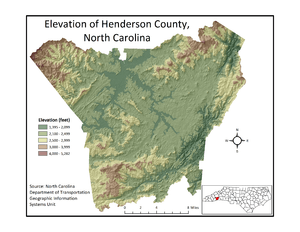
Henderson County is located in the Blue Ridge Mountains of southwestern North Carolina, on the border with South Carolina. The Eastern Continental Divide, which lies along the crest of the Blue Ridge, passes through the county. The northwestern slope of the Divide is known as the Blue Ridge Plateau and the southeastern slope as the Blue Ridge Escarpment. These two physiographic features have unique characteristics that account for wide variations in the county’s climate. According to the U.S. Census Bureau, the county has a total area of 375 square miles (970 km2), of which 373 square miles (970 km2) is land and 2.2 square miles (5.7 km2) (0.6%) is water.[5] The county's largest body of water is Lake Summit, a reservoir impounded by the Duke Power Company for hydroelectric generation. The county's major streams are the French Broad River (whose conjunction with the Holston River forms the Tennessee River, eventually flowing into the Gulf of Mexico), Mills River, Green River, Little River, Mud Creek, Clear Creek, Cane Creek, Hungry River, and the headwaters of the Broad River (which flows into the Congaree River of South Carolina and eventually into the Atlantic Ocean). The lowest point in the county is to be found along the Broad River at approximately 1,394’ feet at the boundary between Henderson and Rutherford Counties in North Carolina. The high point is located on Little Pisgah Mountain at approximately 5,278 feet along the Henderson-Haywood County boundary in North Carolina (Note that a second Little Pisgah Mpuntain at 4412’ is located at the boundary between Henderson and Buncombe counties in North Carolina). According to the U.S. Census Bureau, the county has a total area of 375 square miles (970 km2), of which 373 square miles (970 km2) is land and 2.2 square miles (5.7 km2) (0.6%) is water.[5] The county's largest body of water is Lake Summit, a reservoir impounded by the Duke Power Company for hydroelectric generation.
Landscape and climate
Due to its geographic setting along the Eastern Continental Divide and its extreme topographic variation, Henderson County presents a wide variation in temperature and precipitation conditions. The highest elevations occur along the northwest and northern boundaries of the county and within the Blue Ridge Escarpment, a rugged area of peaks and narrow valleys that rise from the Piedmont to the continental divide and the Blue Ridge Plateau. The lowest elevations occur within the valleys of the escarpment and in the broader valleys of the Blue Ridge Plateau. The mean annual temperature of the county is 55.1°F, with a range from 50.3 to 57.9°F depending on the elevation, with higher temperatures occurring at lower elevations and lower temperatures in the higher mountains. The month of July is the hottest in the county, with a mean temperature of 72.6°F and a mean range of 66.6 to 75.8°F. The coolest month is January with a mean temperature of 36.9°F and a mean range of 33.3 to 39.5°F. Precipitation is also correlated to elevation, with higher precipitation normally occurring at higher elevations and lower precipitation in the valleys. The mean annual precipitation of Henderson County is 56.2 inches, with a mean range of 45.04 to 78.03 inches. March has the highest mean precipitation of 5.1 inches, with a mean range of 3.9 to 6.7 inches. The lowest precipitation occurs in October, with a mean value of 3.9 inches and a mean range of 2.8 to 5.8 inches.
Agriculture
Henderson County's topographic and climatic diversity make it ideal for a great variety of commercial crops and agricultural products. Parts of the county between the Pisgah National Forest on the northwest and the boundary with Polk County on the southeast are often referred to locally as the Crest of the Blue Ridge Agricultural Area in recognition of the region's unique growing conditions. With the exception of tropical fruits and vegetables, local farmers and other agricultural professionals will tell you that almost any commercial crop will grow in Henderson County. At the present time the fruit and berry types being raised include apples, blackberries, blueberries, cantaloupes, cherries, grapes, peaches, plums, raspberries, strawberries and watermelons.
A special word should be said for Henderson County's apple production. Since World War II, apples have been the most important agricultural crop in the county; they require extensive winter chilling, and do not tolerate summer heat and humidity well, so Henderson County, with its cooler climate due to its elevation represents an ideal environment for orchards. Henderson County represents, in fact, the southern limit for large-scale commercial apple production in the eastern United States. The tradition of honoring the local apple industry persists in the county's annual North Carolina Apple Festival, held each year around Labor Day, and culminating in the "King Apple Parade" attended by tens of thousands of spectators.[6]
In addition to fruits and berries a number of commercial vegetable crops are raised in Henderson County, including asparagus, green beans, beets, broccoli, cabbage, cauliflower, carrots, corn, cucumbers, egg plants, greens, herbs, lettuce, mushrooms, okra, onions, peas, peppers (bell and hot), potatoes, pumpkins, radishes, spinach, squash (winter and summer varieties), tomatoes, turnips, and zucchini. Meat, eggs, and dairy products are also important, with beef, fish, goat meat, mountain trout, pork, poultry, sweet and hard cider, wine and cheese being produced in commercial quantities.
Adjacent counties
- Buncombe County - north
- Rutherford County - northeast
- Polk County - east
- Greenville County, South Carolina - south
- Transylvania County - west
- Haywood County - northwest
National protected areas
Major highways
Demographics
| Historical population | |||
|---|---|---|---|
| Census | Pop. | %± | |
| 1840 | 5,129 | — | |
| 1850 | 6,853 | 33.6% | |
| 1860 | 10,448 | 52.5% | |
| 1870 | 7,706 | −26.2% | |
| 1880 | 10,281 | 33.4% | |
| 1890 | 12,589 | 22.4% | |
| 1900 | 14,104 | 12.0% | |
| 1910 | 16,262 | 15.3% | |
| 1920 | 18,248 | 12.2% | |
| 1930 | 23,404 | 28.3% | |
| 1940 | 26,049 | 11.3% | |
| 1950 | 30,921 | 18.7% | |
| 1960 | 36,163 | 17.0% | |
| 1970 | 42,804 | 18.4% | |
| 1980 | 58,580 | 36.9% | |
| 1990 | 69,285 | 18.3% | |
| 2000 | 89,173 | 28.7% | |
| 2010 | 106,740 | 19.7% | |
| Est. 2016 | 114,209 | [7] | 7.0% |
| U.S. Decennial Census[8] 1790-1960[9] 1900-1990[10] 1990-2000[11] 2010-2013[1] | |||
As of the census of 2010, there were 106,740 people, 45,180 households, and 28,613 families residing in the county. The population density was 275.83 people per square mile (92/km²). There were 42,996 housing units at an average density of 115 per square mile (44/km²). The racial makeup of the county was 94.5% White, 3.3% Black or African American, 0.4% Native American, 0.8% Asian, and .9% from two or more races. 8.7% of the population were Hispanic or Latino of any race. The county has seen a marked increase in its Hispanic population segment and Hispanic culture in recent decades, and has also shared in the higher immigration from the countries of the former USSR experienced by neighboring Buncombe County. The influx of retirees from other U.S. states remains strong.
There were 42,205 households out of which 25.6% had children under the age of 18 living with them, 54.1% were married couples living together, 9.9% had a female householder with no husband present, and 32.2% were non-families. 28.3% of all households were made up of individuals and 22% had someone living alone who was 65 years of age or older. The average household size was 2.33 and the average family size was 2.78.
In the county, the population was spread out with 20.80% under the age of 18, 6.30% from 18 to 24, 25.9% from 25 to 44, 26.7% from 45 to 64, and 22.5% who were 65 years of age or older. The median age was 46 years. For every 100 females there were 93.80 males. For every 100 females age 18 and over, there were 90.50 males. Henderson County is characterized by an exceptionally large retiree population.
The median income for a household in the county was $43,013 and the median income for a family was $44,974. Males had a median income of $31,845 versus $23,978 for females. The per capita income for the county was $33,500. About 6.80% of families and 12.9% of the population were below the poverty line, including 14.50% of those under age 18 and 8.30% of those age 65 or over.
Ancestry
As of 2015, the largest self-reported ancestry groups in Henderson County, North Carolina were:[12]
| Largest ancestries (2015) | Percent |
|---|---|
| English | 15.4% |
| "American" | 13.9% |
| German | 13.4% |
| Irish | 12.2% |
| Scots-Irish | 4.7% |
| Scottish | 4.0% |
| Italian | 3.5% |
| French(except Basque) | 2.1% |
| Polish | 1.8% |
| Dutch | 1.5% |
Religion
- Unaffiliated: 44%
- Baptist: 23%
- Methodist: 5%
- Catholic: 4%
- Presbyterian: 3%
- Anglican: 2%
- Seventh Day Adventist: 2%
- Lutheran: 1%
- Pentecostal: 1%
- Other: 15%
Law and government
Henderson County is a member of the Land-of-Sky Regional Council of governments. It is governed by the five-member Henderson County Board of Commissioners:
- Tommy Thompson (Chairman)
- Charlie Messer, (Vice-Chairman)
- Grady Hawkins
- Michael Edney
- William Lapsley
The County Manager is Steve Wyatt. The Henderson County Planning Department publishes statistical information about the county every October.[14]
Politics
Henderson County is located in the 11th Congressional District of North Carolina. The present incumbent is a Republican, Mark Meadows. Both the Henderson County Republican Party and the Henderson County Democratic Party are active, and have their offices in the county seat, Hendersonville. In 2008, there was a vigorous election battle, which witnessed a Democratic surge in what has been historically been one of the more Republican areas of North Carolina.
Since 1880, Henderson County has been carried by a Democrat just five times–Woodrow Wilson in 1912 and Franklin D. Roosevelt in each of his four elections.[15] Since FDR carried the county in 1944, only LBJ in 1964 and Jimmy Carter have managed to win more than 40 percent of the vote. Barack Obama came close to that mark in 2008 as part of the Democratic surge in the area. Possible reasons for this movement away from the Republican Party may include the large influx into the County in recent years of retirees and young professionals from outside the state, as well as the growing economic concerns of the county’s largely rural population.
| Year | Republican | Democratic | Third parties |
|---|---|---|---|
| 2016 | 61.6% 35,809 | 34.1% 19,827 | 4.4% 2,540 |
| 2012 | 63.0% 32,994 | 35.6% 18,642 | 1.4% 756 |
| 2008 | 59.9% 30,930 | 38.9% 20,082 | 1.2% 602 |
| 2004 | 64.8% 28,025 | 34.7% 15,003 | 0.5% 206 |
| 2000 | 66.5% 25,688 | 32.5% 12,562 | 0.9% 357 |
| 1996 | 58.7% 19,182 | 32.5% 10,626 | 8.8% 2,868 |
| 1992 | 51.4% 17,010 | 32.5% 10,747 | 16.1% 5,315 |
| 1988 | 67.7% 19,711 | 32.1% 9,338 | 0.3% 76 |
| 1984 | 72.6% 19,369 | 27.1% 7,222 | 0.4% 106 |
| 1980 | 61.2% 13,573 | 34.2% 7,578 | 4.6% 1,030 |
| 1976 | 56.6% 10,830 | 42.6% 8,155 | 0.9% 162 |
| 1972 | 80.2% 12,134 | 17.9% 2,701 | 2.0% 300 |
| 1968 | 57.5% 9,334 | 18.8% 3,053 | 23.8% 3,861 |
| 1964 | 59.1% 8,780 | 40.9% 6,066 | |
| 1960 | 70.2% 10,835 | 29.9% 4,611 | |
| 1956 | 69.8% 9,243 | 30.2% 4,003 | |
| 1952 | 69.8% 8,768 | 30.3% 3,803 | |
| 1948 | 51.6% 4,971 | 34.4% 3,311 | 14.0% 1,350 |
| 1944 | 44.8% 4,613 | 55.2% 5,679 | |
| 1940 | 36.9% 3,712 | 63.1% 6,336 | |
| 1936 | 47.0% 5,099 | 53.0% 5,747 | |
| 1932 | 44.0% 4,172 | 55.4% 5,255 | 0.7% 63 |
| 1928 | 62.3% 5,210 | 37.7% 3,149 | |
| 1924 | 53.7% 3,548 | 45.5% 3,007 | 0.7% 48 |
| 1920 | 57.2% 3,337 | 42.8% 2,496 | |
| 1916 | 60.6% 1,795 | 39.4% 1,166 | |
| 1912 | 35.2% 801 | 48.0% 1,092 | 16.8% 382 |
Political news and civic affairs are covered by the county’s daily newspaper, the Times-News of Hendersonville.
Cities and towns
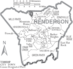
Cities
- Hendersonville (county seat)
- Saluda
Towns
Village
Census-designated places
Unincorporated communities
Townships
- Blue Ridge
- Clear Creek
- Crab Creek
- Edneyville
- Green River
- Hendersonville
- Hoopers Creek
- Mills River
See also
Footnotes
- 1 2 "State & County QuickFacts". United States Census Bureau. Archived from the original on July 11, 2011. Retrieved October 21, 2013.
- ↑ "Find a County". National Association of Counties. Archived from the original on 2011-05-31. Retrieved 2011-06-07.
- ↑ Gannett, Henry (1905). The Origin of Certain Place Names in the United States. Govt. Print. Off. p. 154.
- ↑ Kramp, Penn (Feb 22, 1987). "Tuxedo: It's not formal wear". The Times-News. p. 27. Retrieved 23 May 2015.
- ↑ "2010 Census Gazetteer Files". United States Census Bureau. August 22, 2012. Archived from the original on January 12, 2015. Retrieved January 17, 2015.
- ↑ "Events". North Carolina Apple Festival. Retrieved April 5, 2012.
- ↑ "Population and Housing Unit Estimates". Retrieved June 9, 2017.
- ↑ "U.S. Decennial Census". United States Census Bureau. Archived from the original on May 12, 2015. Retrieved January 17, 2015.
- ↑ "Historical Census Browser". University of Virginia Library. Retrieved January 17, 2015.
- ↑ Forstall, Richard L., ed. (March 27, 1995). "Population of Counties by Decennial Census: 1900 to 1990". United States Census Bureau. Retrieved January 17, 2015.
- ↑ "Census 2000 PHC-T-4. Ranking Tables for Counties: 1990 and 2000" (PDF). United States Census Bureau. April 2, 2001. Retrieved January 17, 2015.
- ↑ Bureau, U.S. Census. "American FactFinder - Results". factfinder.census.gov. Retrieved 2018-03-15.
- ↑ "Religions in Henderson County, NC". www.city-data.com. Retrieved 2018-03-15.
- ↑ "Henderson County Annual Profile of Statistical Information". County of Henderson. Retrieved April 5, 2012.
- ↑ Menendez, Albert J.; The Geography of Presidential Elections in the United States, 1868-2004, pp. 265-271 ISBN 0786422173
- ↑ Leip, David. "Dave Leip's Atlas of U.S. Presidential Elections". uselectionatlas.org. Retrieved 2018-03-15.
Further reading
- Jody Barber and Louise Howe Bailey, Hendersonville and Henderson County: A Pictorial History. Norfolk, VA: Donning Co., 1988.
- James T. Fain, Henderson County — The Past 137 Years: A Chronicle of the History of Hendersonville and Henderson County Featuring Original Photographs Depicting our Area and its People. Hendersonville, NC: Times-News Co., 1976.
External links
- Henderson County Official Website
- Henderson County Visitors Center
- HendersonvilleNews.com - The Times-News Online
- Henderson County Partnership for Economic Development
- Carolina Mountain Land Conservancy
- Henderson County Habitat for Humanity
- Camplify
Places adjacent to Henderson County, North Carolina | ||||||||||
|---|---|---|---|---|---|---|---|---|---|---|
| ||||||||||
Municipalities and communities of Henderson County, North Carolina, United States | ||
|---|---|---|
| Cities | 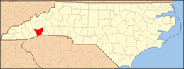 | |
| Towns | ||
| Village | ||
| CDPs | ||
| Unincorporated communities | ||
| Footnotes | ‡This populated place also has portions in an adjacent county or counties | |
